

Hail Swath Map Preview
The Saint Louis, MO hail swath map preview was last reviewed on August 29, 2026 and shows mapped hail estimates up to 2.00". There are 8 public hail reports, 33 public wind reports, and 9 nearby tornado reports listed for the April 18, 2024 event.
View the April 18, 2024 Saint Louis, MO hail event on the free interactive hail map, then check a free Hail Report by ZIP to see a more local hail signal for your area.
Impact Area and Population for the Saint Louis, MO Hail Map
The April 18, 2024 hail swath map for Saint Louis, MO covers approximately 3,310 square miles and includes an estimated 674,398 people inside the mapped footprint. The largest mapped area is in the 0.50-0.75" hail band, covering 1,523 square miles. The highest estimated population exposure is in the 0.50-0.75" hail band with 369,540 people.
| Mapped Hail Band | Impact Area | Population |
|---|---|---|
| < 0.50" | 1,351 sq mi | 246,385 |
| 0.50-0.75" | 1,523 sq mi | 369,540 |
| 0.75-1.00" | 349 sq mi | 54,840 |
| 1.00-1.25" | 48 sq mi | 2,457 |
| 1.25-1.50" | 19 sq mi | 651 |
| 1.50-1.75" | 8 sq mi | 245 |
| 1.75-2.00" | 7 sq mi | 173 |
| 2.00-2.25" | 5 sq mi | 107 |
Get a free Hail Report by ZIP to see a more local hail signal and whether the April 18, 2024 Saint Louis, MO hail event may have reached your area.
Housing Exposure Inside the Saint Louis, MO Hail Swath Map
Inside the April 18, 2024 hail swath map area for Saint Louis, MO, HailGeeks estimates 311,800 single-family homes, 20,053 townhomes, and 153,025 multifamily properties within the mapped storm footprint. Single-family-home exposure is highest in the 0.50-0.75" hail band, with 172,738 single-family homes.
| Mapped Hail Band | Single-Family | Townhomes | Multifamily |
|---|---|---|---|
| < 0.50" | 105,878 | 6,325 | 46,295 |
| 0.50-0.75" | 172,738 | 11,857 | 91,685 |
| 0.75-1.00" | 31,297 | 1,843 | 14,913 |
| 1.00-1.25" | 1,329 | 28 | 108 |
| 1.25-1.50" | 328 | 0 | 20 |
| 1.50-1.75" | 109 | 0 | 2 |
| 1.75-2.00" | 76 | 0 | 1 |
| 2.00-2.25" | 45 | 0 | 1 |
Use this table to review housing exposure by hail band for the April 18, 2024 Saint Louis, MO hail map. To check a specific property more closely, use a free Hail Report by Address.
Counties Inside the Saint Louis, MO Hail Map
Hail from the April 18, 2024 storm was mapped across 30 counties in the Saint Louis, MO region. Lincoln County, MO had the strongest mapped signal, peaking at 2.00" with roughly 2,009 single-family homes inside the swath.
County pages group every mapped hail event in the area. For a closer look, drop to the city or ZIP level below, or run a free Hail Report by Address.
Cities Inside the Saint Louis, MO Hail Map
Zooming in, the swath touched 131 cities near Saint Louis, MO. Silex, MO had the strongest mapped signal at 2.00", with an estimated 14 single-family homes exposed.
City cards show where the April 18, 2024 Saint Louis, MO hail activity was mapped, but your ZIP can show a closer local signal. Get a free Hail Report by ZIP, and if the signal looks meaningful, ask a local pro about a Remote Hail Inspection to see whether an on-site roof or exterior review may be worth scheduling.
ZIP Codes Inside the Saint Louis, MO Hail Swath Map
At the ZIP level, the April 18, 2024 Saint Louis, MO hail map spans 173 ZIP codes. ZIP 63343 shows the strongest local signal, with mapped hail estimates up to 2.00" and an estimated single-family-home exposure of 912.
Check your ZIP in seconds to see whether hail activity from the April 18, 2024 Saint Louis, MO event was mapped near your area.
Public Hail, Wind, and Tornado Reports
Public storm report tables connected to the April 18, 2024 hail map for Saint Louis, MO currently list 8 public hail reports, 33 public wind reports, and 9 tornado reports.
| Date & Time | Hail Size | City | State | Description |
|---|---|---|---|---|
April 18, 2024 4:11 PM CT |
1.00 in | 5 W Silex | MO | No National Weather Service description provided. |
April 18, 2024 4:28 PM CT |
1.00 in | 3 E Silex | MO | time estimate from radar. |
April 18, 2024 4:30 PM CT |
1.75 in | 4 NE Davis | MO | Photo of hail estimated to be at least golf ball size from social media. |
April 18, 2024 4:40 PM CT |
1.00 in | New Hope | MO | Photo of hail estimated to be at least quarter size on social media. |
April 18, 2024 5:21 PM CT |
1.00 in | 1 NNW Woodson Terrace | MO | Corrects previous hail report from 1 NNW Woodson Terrace. |
April 18, 2024 6:04 PM CT |
1.50 in | 2 S Benld | IL | Report from mPING: Ping Pong Ball (1.50 in.). |
April 18, 2024 6:55 PM CT |
1.25 in | Okawville | IL | No National Weather Service description provided. |
April 18, 2024 7:02 PM CT |
1.00 in | 2 S Addieville | IL | No National Weather Service description provided. |
| Date & Time | Wind Speed | City | State | Description |
|---|---|---|---|---|
April 19, 2024 5:51 AM CT | 2 ESE Brooklyn | IL | Large metal section of bleachers blown down at Gateway Motorspark Park. Wind speeds estimated to be near 80 mph. Time estimated from radar. | |
April 18, 2024 5:37 PM CT | Dittmer | MO | Photo of tree limb snapped and fallen on a home from social media. | |
April 18, 2024 5:40 PM CT | 1 E East Carondelet | IL | location approximate... time estimate from radar... multiple trees and powerlines down. | |
April 18, 2024 5:41 PM CT | 2 SW Lakeshire | MO | Report from mPING: 3-inch tree limbs broken; Power poles broken. | |
April 18, 2024 5:43 PM CT | University City | MO | Report from mPING: 1-inch tree limbs broken; Shingles blown off. | |
April 18, 2024 5:44 PM CT | 1 SW Fenton | MO | Flashing ripped off roof. | |
April 18, 2024 5:45 PM CT | 2 SW Lakeshire | MO | tree down... time estimate from radar. | |
April 18, 2024 5:45 PM CT | 2 S Sunset Hills | MO | Several downed treee branches. | |
April 18, 2024 5:48 PM CT | 1 W Mehlville | MO | A few shingles blown off of roofs. | |
April 18, 2024 5:49 PM CT | 2 SW Lakeshire | MO | Medium diameter tree broke at mid point from top. | |
April 18, 2024 5:50 PM CT | 2 SW Lakeshire | MO | Multiple large trees blown over. One of the fallen trees blocked a road... and another fallen tree fell on a neighborhood house. | |
April 18, 2024 5:50 PM CT | 1 WNW Mehlville | MO | Photo of large portion of pine tree fallen on the ground from social media. | |
April 18, 2024 5:50 PM CT | 2 N Arnold | MO | Report from mPING: 1-inch tree limbs broken; Shingles blown off. | |
April 18, 2024 5:50 PM CT | 2 NW Arnold | MO | Report from mPING: 1-inch tree limbs broken; Shingles blown off. | |
April 18, 2024 5:51 PM CT | 1 NW Mehlville | MO | Report from mPING: 3-inch tree limbs broken; Power poles broken. | |
April 18, 2024 5:51 PM CT | 1 N Mehlville | MO | Photo of multiple large tree limbs down at Covington Manor Ln and Lemay Ferry Rd. | |
April 18, 2024 5:51 PM CT | 1 NNE Oakville | MO | 2-3inch live limbs down... 2-3 up-rooted trees... shingles off... bent trees. | |
April 18, 2024 5:51 PM CT | 2 SE Sunset Hills | MO | Report from mPING: 1-inch tree limbs broken; Shingles blown off. | |
April 18, 2024 5:52 PM CT | 2 NE Oakville | MO | Report from mPING: Trees uprooted or snapped; Roof blown off. | |
April 18, 2024 5:54 PM CT | 1 WNW Mehlville | MO | Turn signal light blown down by thunderstorm winds. | |
April 18, 2024 5:57 PM CT | 1 SW Dupo | IL | Report from mPING: 3-inch tree limbs broken; Power poles broken. | |
April 18, 2024 5:57 PM CT | 2 NW Columbia | IL | Report from mPING: 1-inch tree limbs broken; Shingles blown off. | |
April 18, 2024 6:02 PM CT | 1 S Prairietown | IL | Report from mPING: Trees uprooted or snapped; Roof blown off. | |
April 18, 2024 6:05 PM CT | 1 E Troy | IL | Large tree blown over. | |
April 18, 2024 6:06 PM CT | Worden | IL | power poles down. | |
April 18, 2024 6:14 PM CT | Marine | IL | Corrects previous tornado report from Marine. Corrects previous tstm wnd dmg report from Marine. trees down... trees in houses... and powerlines down. | |
April 18, 2024 6:15 PM CT | 2 ESE Centreville | IL | Downed tree and powerlines. | |
April 18, 2024 6:15 PM CT | Marine | IL | trees down... trees in houses... and powerlines down. | |
April 18, 2024 6:18 PM CT | 1 E O'Fallon | IL | Report from mPING: 3-inch tree limbs broken; Power poles broken. | |
April 18, 2024 6:18 PM CT | 2 WNW New Douglas | IL | Photo of a tree snapped in half at Rustic Acres Jellystone Park from social media. | |
April 18, 2024 6:18 PM CT | New Douglas | IL | power poles down. | |
April 18, 2024 6:19 PM CT | 1 NW Fairview Heights | IL | Report from mPING: 3-inch tree limbs broken; Power poles broken. | |
April 18, 2024 6:55 PM CT | 1 ENE Okawville | IL | Tree debris was found off of I-64 at the Okawville exit. Time estimated from radar. |
| Date & Time | Rating | City | State | Description |
|---|---|---|---|---|
April 18, 2024 5:33 PM CT | UNK | 3 NW Byrnes Mill | MO | EF1 damage to buildings at business along Twin Rivers Road. Tornado Debris Signature (TDS) was observed on radar at this time. Survey is continuing. |
April 18, 2024 5:36 PM CT | UNK | 1 W Kemper | IL | Spotter reported a brief tornado touchdown. Storm survey did not find any damage so rated EFU. |
April 18, 2024 5:38 PM CT | UNK | 1 SSW High Ridge | MO | Storm survey ongoing with EF0 tornado damage near High Ridge along Highway PP and along Hunning Road. This is a continuation of the track from Twin Rivers Road (northern Jefferson County). |
April 18, 2024 5:52 PM CT | UNK | 1 S Pontoon Beach | IL | Tree damage with winds up to 80 mph. NWS storm survey continues. |
April 18, 2024 5:52 PM CT | UNK | 3 S Standard City | IL | A brief tornado touched down south of Standard City where it damaged the roofs of 3 farm sheds. The tornado moved southeast across South Standard City Rd where it caused tree damage before lifting. Path length 0.23 miles. Estimated peak wind speed 95 mph. Rating EF1. |
April 18, 2024 5:58 PM CT | UNK | 1 SE Cahokia | IL | The tornado touched down near the western edge of the Prairies of Cahokia Golf Course and moved east for about 1.1 miles where it lifted near the intersection of Carol Rd and Lynn St. Damage consisted of uprooted trees and broken tree limbs. Estimated peak wind was 76 mph. Rating EF0. |
April 18, 2024 6:01 PM CT | UNK | 1 S Prairietown | IL | Corrects previous tstm wnd dmg report from 1 S Prairietown. Report from mPING: Trees uprooted or snapped; Roof blown off. NWS survey team found EF1 damage with max winds to 95 mph. |
April 18, 2024 6:09 PM CT | UNK | 3 SE Kuhn | IL | Tree damage (limbs snapped) and minor roof damage (shingles off) along Lower Marine Road. NWS storm survey continues. |
April 18, 2024 6:14 PM CT | UNK | Marine | IL | Corrects previous tstm wnd dmg report from Marine. trees down... trees in houses... and powerlines down. NWS survey team determined the damage was from a EF0 tornado. Maximum winds of 80 mph. |
This table includes only public storm reports connected to the April 18, 2024 Saint Louis, MO storm event. When available, each report may include the time, size or magnitude, city, state, and a short description.
Related Hail Maps in the Saint Louis, MO Region
We found 6 more hail maps with reports from the same Saint Louis, MO region as the April 18, 2024 event. These related maps cover storm dates from Mar 13, 2024 through Apr 16, 2024, with mapped hail estimates ranging from 0.75" to 3.25". In this set, the strongest related map reached 3.25", and the most recent map shown is from Apr 16, 2024.

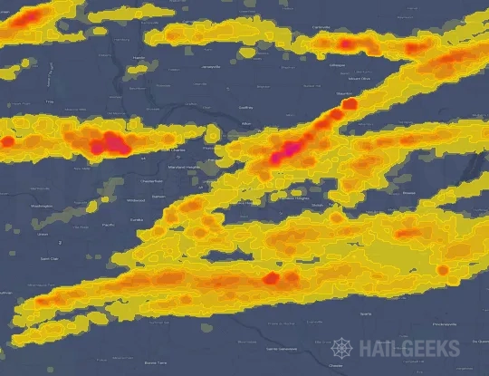
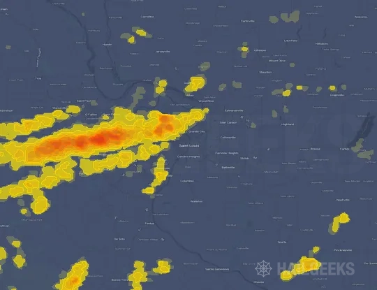


If none of these related Saint Louis, MO hail maps look close enough to your property, check a free Hail Report by Address. It reviews hail history for a specific location — not just the broader Saint Louis, MO region — so you can check whether hail activity may have reached your property.
Local Hail Review Options Near Saint Louis, MO
Not sure whether the April 18, 2024 Saint Louis, MO hail map matters for your property? Start with a free Hail Report by Address to see whether hail activity was mapped for that property. If the property signal looks meaningful, you can choose a local pro serving the Saint Louis, MO region and ask about a Remote Hail Inspection before deciding whether an on-site roof or exterior review is worth scheduling.
Check a specific property to see whether hail activity from the April 18, 2024 Saint Louis, MO event — or another recent hail event — may have been mapped at that address.
Find a roof or exterior pro serving the Saint Louis, MO region who can help you understand what the property hail signal may mean.
A participating local pro reviews property-level hail history remotely — not just the April 18, 2024 event — to help decide whether an on-site inspection may be worth scheduling.
A free Hail Report by Address and a Remote Hail Inspection can help you look beyond the April 18, 2024 hail map visuals alone. They do not confirm property damage and do not replace an on-site inspection for a property in the Saint Louis, MO region, but they can help you make a more informed next decision before anyone climbs on the roof.
Frequently Asked Questions
Common questions about the April 18, 2024 Saint Louis, MO hail event.