

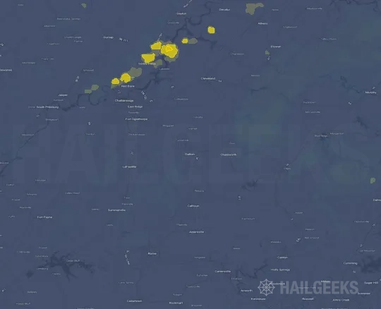
Hail Swath Map Preview
The Dalton, GA hail swath map preview was last reviewed on August 29, 2026 and shows mapped hail estimates up to 1.50". There are 1 public hail reports, 49 public wind reports, and 0 nearby tornado reports listed for the July 30, 2024 event.
View the July 30, 2024 Dalton, GA hail event on the free interactive hail map, then check a free Hail Report by ZIP to see a more local hail signal for your area.
Impact Area and Population for the Dalton, GA Hail Map
The July 30, 2024 hail swath map for Dalton, GA covers approximately 468 square miles and includes an estimated 55,198 people inside the mapped footprint. The largest mapped area is in the < 0.50" hail band, covering 197 square miles. The highest estimated population exposure is in the < 0.50" hail band with 20,538 people.
| Mapped Hail Band | Impact Area | Population |
|---|---|---|
| < 0.50" | 197 sq mi | 20,538 |
| 0.50-0.75" | 178 sq mi | 16,350 |
| 0.75-1.00" | 58 sq mi | 8,996 |
| 1.00-1.25" | 26 sq mi | 6,517 |
| 1.25-1.50" | 5 sq mi | 1,430 |
| 1.50-1.75" | 4 sq mi | 1,367 |
Get a free Hail Report by ZIP to see a more local hail signal and whether the July 30, 2024 Dalton, GA hail event may have reached your area.
Housing Exposure Inside the Dalton, GA Hail Swath Map
Inside the July 30, 2024 hail swath map area for Dalton, GA, HailGeeks estimates 23,166 single-family homes, 1,103 townhomes, and 3,169 multifamily properties within the mapped storm footprint. Single-family-home exposure is highest in the < 0.50" hail band, with 9,054 single-family homes.
| Mapped Hail Band | Single-Family | Townhomes | Multifamily |
|---|---|---|---|
| < 0.50" | 9,054 | 602 | 1,157 |
| 0.50-0.75" | 6,367 | 344 | 1,087 |
| 0.75-1.00" | 4,009 | 72 | 413 |
| 1.00-1.25" | 2,757 | 53 | 468 |
| 1.25-1.50" | 494 | 18 | 12 |
| 1.50-1.75" | 485 | 14 | 32 |
Use this table to review housing exposure by hail band for the July 30, 2024 Dalton, GA hail map. To check a specific property more closely, use a free Hail Report by Address.
Counties Inside the Dalton, GA Hail Map
Hail from the July 30, 2024 storm was mapped across 19 counties in the Dalton, GA region. Whitfield County, GA had the strongest mapped signal, peaking at 1.50" with roughly 9,009 single-family homes inside the swath.
County pages group every mapped hail event in the area. For a closer look, drop to the city or ZIP level below, or run a free Hail Report by Address.
Cities Inside the Dalton, GA Hail Map
Zooming in, the swath touched 10 cities near Dalton, GA. Varnell, GA had the strongest mapped signal at 1.50", with an estimated 1,618 single-family homes exposed.
City cards show where the July 30, 2024 Dalton, GA hail activity was mapped, but your ZIP can show a closer local signal. Get a free Hail Report by ZIP, and if the signal looks meaningful, ask a local pro about a Remote Hail Inspection to see whether an on-site roof or exterior review may be worth scheduling.
ZIP Codes Inside the Dalton, GA Hail Swath Map
At the ZIP level, the July 30, 2024 Dalton, GA hail map spans 24 ZIP codes. ZIP 30721 shows the strongest local signal, with mapped hail estimates up to 1.50" and an estimated single-family-home exposure of 4,918.
Check your ZIP in seconds to see whether hail activity from the July 30, 2024 Dalton, GA event was mapped near your area.
Public Hail, Wind, and Tornado Reports
Public storm report tables connected to the July 30, 2024 hail map for Dalton, GA currently list 1 public hail reports, 49 public wind reports, and 0 tornado reports.
| Date & Time | Hail Size | City | State | Description |
|---|---|---|---|---|
July 30, 2024 6:46 PM CT |
1.00 in | 4 SSE Varnell | GA | Quarter inch hail reported at Woodridge Lane and Bethany Drive. |
| Date & Time | Wind Speed | City | State | Description |
|---|---|---|---|---|
July 30, 2024 3:46 PM CT | 1 ESE Dalton | GA | Tree on home on 600 block of Hannah Court. | |
July 30, 2024 4:30 PM CT | Dayton | TN | Several trees down. | |
July 30, 2024 4:40 PM CT | Altamont | TN | Facebook posts show much of the Altamont City Hall sheet metal roof was blown off. Time estimated based on radar. | |
July 30, 2024 4:50 PM CT | Athens | TN | Multiple trees and power lines down from Athens to the northern portions of the county. | |
July 30, 2024 5:02 PM CT | 1 WNW Cleveland | TN | Tree down. Some home damage. | |
July 30, 2024 5:05 PM CT | 3 E Red Bank | TN | A large tree was felled near Chickamauga Dam. | |
July 30, 2024 5:15 PM CT | Cleveland | TN | Multiple trees and power Lines down in Cleveland and across the county. Reported by HAM radio operator. Time estimated by radar. | |
July 30, 2024 5:20 PM CT | Unaka | NC | Multiple powerlines down across the county. | |
July 30, 2024 5:22 PM CT | 1 NW Cohutta | GA | Tree down at Apison Road and Parrott Road. | |
July 30, 2024 5:23 PM CT | 2 NE Turtletown | TN | Reported by Trained Spotter. Trees down in Farner Tennessee. | |
July 30, 2024 5:25 PM CT | 1 E Mccaysville-Copperh | GA | Trees down near intersection of River Road and Toccoa Ave in McCaysville. | |
July 30, 2024 5:30 PM CT | 5 N Loving | GA | Multiple trees down around the Mineral Bluff area in northern Fannin County. This was along Mount Pleasant Road. | |
July 30, 2024 5:30 PM CT | 3 NNW Mineral Bluff | GA | Trees down along Salem Road near Humphrey Mill Road. | |
July 30, 2024 5:32 PM CT | 3 WNW Blue Ridge | GA | Trees down along Tennis Court Road. | |
July 30, 2024 5:35 PM CT | 4 N Murphy | NC | Multiple trees down in the area. | |
July 30, 2024 5:35 PM CT | 2 W Nottely Dam | GA | A power pole was snapped on Jonica Gap Rd at Loving Rd. | |
July 30, 2024 5:40 PM CT | 3 S Nottely Dam | GA | A tree was downed on Lake Cove Lodge Rd at Dixie Dr. | |
July 30, 2024 5:40 PM CT | 2 E Ivy Log | GA | A tree was downed on Ivylog Drive near Hideaway Hills Road. | |
July 30, 2024 5:41 PM CT | 3 E Eton | GA | Tree on roadway at Old CCC Camp Road and Crandall Ellijay Road. | |
July 30, 2024 5:51 PM CT | 2 SSE Dawnville | GA | Large tree on home at Miller Drive and Morning Dove Way. | |
July 30, 2024 5:55 PM CT | 3 WSW Cherry Log | GA | Trees down along Boardtown Road. | |
July 30, 2024 6:00 PM CT | 1 W Chatsworth | GA | Tree down at HWY 52 Alt and Sitton Road. | |
July 30, 2024 6:00 PM CT | 2 SSE Roundtop | GA | Trees down along Roud Top Road. | |
July 30, 2024 6:15 PM CT | 1 SE Calhoun | GA | Multiple reports of trees down along Linda Lane. | |
July 30, 2024 6:20 PM CT | 3 SE Oostanaula | GA | Trees down along Oak Grove Road SW. | |
July 30, 2024 6:25 PM CT | 3 SW Nimblewill | GA | Trees down along Little Mountain Road. Additional trees down along Wesley Chapel Road. | |
July 30, 2024 6:29 PM CT | 1 E Hinton | GA | Tree down at HWY 53 and Arrowhead Way. | |
July 30, 2024 6:30 PM CT | 3 ESE Center Post | GA | Trees down near intersection of Ridgeway Drive and Chattooga Line Road. | |
July 30, 2024 6:30 PM CT | 2 SE Center Post | GA | Trees down across Long Hollow Road blocking all lanes of traffic. | |
July 30, 2024 6:35 PM CT | Waleska | GA | Tree down on roadway on Grady Street near Old R.M. Moore School. | |
July 30, 2024 6:40 PM CT | 2 SW Kingston | GA | Trees and power lines down near intersection of Hwy 411 and Reynolds Bridge Road. | |
July 30, 2024 6:41 PM CT | Ball Ground | GA | Multiple trees down in the Ball Ground area. | |
July 30, 2024 6:45 PM CT | 1 WSW Summerville | GA | Tree partially down on a home along Roberts Street. Power lines also down in the area. | |
July 30, 2024 6:45 PM CT | 1 ESE Cassville | GA | Tree down on power lines along Rudy York Road NW. | |
July 30, 2024 6:47 PM CT | Ball Ground | GA | Tree down at Gilmer Ferry and Gazaway Lane. | |
July 30, 2024 6:47 PM CT | Reavis Mountain | GA | Tree down at Reavus Mountain Road and Cherokee Gold Trail. | |
July 30, 2024 6:47 PM CT | Canton | GA | Multiple trees down in the Canton area. | |
July 30, 2024 6:47 PM CT | 1 NNE Hollis Lathem Res | GA | Multiple trees down along Kellie Bridge Road between Cowart Road and Love Lady Road. | |
July 30, 2024 6:47 PM CT | 2 ESE Canton | GA | A tree was downed onto a home in the 3000 block of Cherokee Overlook Drive. | |
July 30, 2024 6:50 PM CT | 1 W Little River Landin | GA | A tree was downed onto a structure in the 1400 block of Towne Harbor Passage. | |
July 30, 2024 6:51 PM CT | Dalton | GA | At least 13 trees reported down across Dalton. | |
July 30, 2024 6:51 PM CT | 2 SE Dalton | GA | Tree down at Riverbend Road and Henton Road. | |
July 30, 2024 6:52 PM CT | 2 S Hickory Flat | GA | *** 1 FATAL *** Tree down on vehicle along Vaughn Road... 0.2 miles south of Millstone Way. | |
July 30, 2024 6:52 PM CT | Pinson | GA | Tree down along Gaines Loop Road NE. | |
July 30, 2024 6:52 PM CT | 1 ENE Woodstock | GA | A tree was downed onto a structure in the 100 block of Hideaway Village Rd. | |
July 30, 2024 6:55 PM CT | 1 SW Emerson | GA | Trees and power lines down near intersection of Old Old Alabama Rd SE and Red Top Circle SE. | |
July 30, 2024 6:58 PM CT | 4 SSE Shannon | GA | Tree down at Wiseman Road and McClain Road. | |
July 30, 2024 4:34 PM CT | 60 mph | 6 NNW Dunlap | TN | No National Weather Service description provided. |
July 30, 2024 5:16 PM CT | 62 mph | 4 SE Chattanooga | TN | ASOS at Chattanooga Airport measured a 62 mph gust. |
| Date & Time | Rating | City | State | Description |
|---|---|---|---|---|
| No public tornado reports are available for this event. | ||||
This table includes only public storm reports connected to the July 30, 2024 Dalton, GA storm event. When available, each report may include the time, size or magnitude, city, state, and a short description.
Related Hail Maps in the Dalton, GA Region
We found 6 more hail maps with reports from the same Dalton, GA region as the July 30, 2024 event. These related maps cover storm dates from Jul 5, 2024 through Jul 21, 2024, with mapped hail estimates ranging from 0.75" to 1.25". In this set, the strongest related map reached 1.25", and the most recent map shown is from Jul 21, 2024.


If none of these related Dalton, GA hail maps look close enough to your property, check a free Hail Report by Address. It reviews hail history for a specific location — not just the broader Dalton, GA region — so you can check whether hail activity may have reached your property.
Local Hail Review Options Near Dalton, GA
Not sure whether the July 30, 2024 Dalton, GA hail map matters for your property? Start with a free Hail Report by Address to see whether hail activity was mapped for that property. If the property signal looks meaningful, you can choose a local pro serving the Dalton, GA region and ask about a Remote Hail Inspection before deciding whether an on-site roof or exterior review is worth scheduling.
Check a specific property to see whether hail activity from the July 30, 2024 Dalton, GA event — or another recent hail event — may have been mapped at that address.
Find a roof or exterior pro serving the Dalton, GA region who can help you understand what the property hail signal may mean.
A participating local pro reviews property-level hail history remotely — not just the July 30, 2024 event — to help decide whether an on-site inspection may be worth scheduling.
A free Hail Report by Address and a Remote Hail Inspection can help you look beyond the July 30, 2024 hail map visuals alone. They do not confirm property damage and do not replace an on-site inspection for a property in the Dalton, GA region, but they can help you make a more informed next decision before anyone climbs on the roof.
Frequently Asked Questions
Common questions about the July 30, 2024 Dalton, GA hail event.