

Hail Swath Map Preview
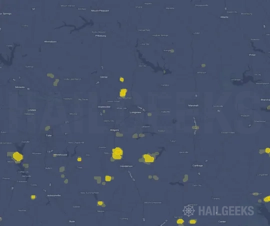
The Longview, TX hail swath map preview was last reviewed on August 29, 2026 and shows mapped hail estimates up to 2.75". There are 2 public hail reports, 15 public wind reports, and 4 nearby tornado reports listed for the March 4, 2025 event.
View the March 4, 2025 Longview, TX hail event on the free interactive hail map, then check a free Hail Report by ZIP to see a more local hail signal for your area.
Impact Area and Population for the Longview, TX Hail Map
The March 4, 2025 hail swath map for Longview, TX covers approximately 434 square miles and includes an estimated 47,398 people inside the mapped footprint. The largest mapped area is in the < 0.50" hail band, covering 219 square miles. The highest estimated population exposure is in the < 0.50" hail band with 35,892 people.
| Mapped Hail Band | Impact Area | Population |
|---|---|---|
| < 0.50" | 219 sq mi | 35,892 |
| 0.50-0.75" | 170 sq mi | 10,384 |
| 0.75-1.00" | 38 sq mi | 914 |
| 2.50-2.75" | 2 sq mi | 61 |
| 2.75-3.00" | 5 sq mi | 147 |
Get a free Hail Report by ZIP to see a more local hail signal and whether the March 4, 2025 Longview, TX hail event may have reached your area.
Housing Exposure Inside the Longview, TX Hail Swath Map
Inside the March 4, 2025 hail swath map area for Longview, TX, HailGeeks estimates 19,297 single-family homes, 602 townhomes, and 4,013 multifamily properties within the mapped storm footprint. Single-family-home exposure is highest in the < 0.50" hail band, with 14,288 single-family homes.
| Mapped Hail Band | Single-Family | Townhomes | Multifamily |
|---|---|---|---|
| < 0.50" | 14,288 | 484 | 3,599 |
| 0.50-0.75" | 4,480 | 118 | 354 |
| 0.75-1.00" | 432 | 0 | 44 |
| 2.50-2.75" | 27 | 0 | 4 |
| 2.75-3.00" | 70 | 0 | 12 |
Use this table to review housing exposure by hail band for the March 4, 2025 Longview, TX hail map. To check a specific property more closely, use a free Hail Report by Address.
Counties Inside the Longview, TX Hail Map
Hail from the March 4, 2025 storm was mapped across 5 counties in the Longview, TX region. Anderson County, TX had the strongest mapped signal, peaking at 2.75" with roughly 1,108 single-family homes inside the swath.
County pages group every mapped hail event in the area. For a closer look, drop to the city or ZIP level below, or run a free Hail Report by Address.
Cities Inside the Longview, TX Hail Map
Zooming in, the swath touched 5 cities near Longview, TX. Tyler, TX had the strongest mapped signal at 0.50", with an estimated 2,664 single-family homes exposed.
City cards show where the March 4, 2025 Longview, TX hail activity was mapped, but your ZIP can show a closer local signal. Get a free Hail Report by ZIP, and if the signal looks meaningful, ask a local pro about a Remote Hail Inspection to see whether an on-site roof or exterior review may be worth scheduling.
ZIP Codes Inside the Longview, TX Hail Swath Map
At the ZIP level, the March 4, 2025 Longview, TX hail map spans 12 ZIP codes. ZIP 75803 shows the strongest local signal, with mapped hail estimates up to 2.75" and an estimated single-family-home exposure of 619.
Check your ZIP in seconds to see whether hail activity from the March 4, 2025 Longview, TX event was mapped near your area.
Public Hail, Wind, and Tornado Reports
Public storm report tables connected to the March 4, 2025 hail map for Longview, TX currently list 2 public hail reports, 15 public wind reports, and 4 tornado reports.
| Date & Time | Hail Size | City | State | Description |
|---|---|---|---|---|
March 4, 2025 6:30 AM CT |
3.00 in | 10 NE Palestine | TX | Images of measured three inch hailstone. Two other hailstones in photo approximately golf ball sized. |
March 4, 2025 7:30 AM CT |
3.00 in | 10 NE Palestine | TX | Images of measured three inch hailstone. Two other hailstones in photo approximately golf ball sized. |
| Date & Time | Wind Speed | City | State | Description |
|---|---|---|---|---|
March 4, 2025 6:32 AM CT | 2 ESE Alba | TX | A metal southwest facing wall of a pole barn was blown down at a residence off of County Road 1600 near County Road 1609. | |
March 4, 2025 7:00 AM CT | 3 N Mount Vernon | TX | Report from mPING: 1-inch tree limbs broken; Shingles blown off. | |
March 4, 2025 7:00 AM CT | 1 N Mount Vernon | TX | Report from mPING: 1-inch tree limbs broken; Shingles blown off. | |
March 4, 2025 7:23 AM CT | 5 W Bullard | TX | Storm spotter report of trees down near 344 and 346 (Teaselville... TX). | |
March 4, 2025 7:30 AM CT | 2 SSW Tyler | TX | Spotter reported power line down on top of a car near intersection of Kinsey Dr and Loop 323 (Tyler... TX). | |
March 4, 2025 7:38 AM CT | 2 NNE Rocky Mound | TX | Reports of overturned camper trailers at BigAl Barefoot Bay north of Rochy Mound... TX. Unknown number of injuries reported. | |
March 4, 2025 7:38 AM CT | 3 S Mount Pleasant | TX | Report from mPING: 3-inch tree limbs broken; Power poles broken. | |
March 4, 2025 7:41 AM CT | 5 S Pittsburg | TX | Report from mPING: 1-inch tree limbs broken; Shingles blown off. | |
March 4, 2025 7:44 AM CT | 5 W Daingerfield | TX | Tree down on a vehicle in Cason. | |
March 4, 2025 7:55 AM CT | 2 SE Lone Star | TX | Report from mPING: 3-inch tree limbs broken; Power poles broken. | |
March 4, 2025 8:13 AM CT | New London | TX | Report of trees down near the intersection of SH 42 and FM 850. Including a tree fallen on FM 850 blocking the road. | |
March 4, 2025 8:20 AM CT | 5 S New London | TX | 911 call of multiple trees down along Block County Road 4105. | |
March 4, 2025 8:20 AM CT | 1 W Overton | TX | Report of trees and powerlines down over N Holiday Blvd in Overton... TX. | |
March 4, 2025 8:23 AM CT | 1 S Gilmer | TX | Report from mPING: 1-inch tree limbs broken; Shingles blown off. | |
March 4, 2025 7:35 AM CT | 58 mph | 4 S Mount Pleasant | TX | Measured at the Mount Pleasant Regional Airport. |
| Date & Time | Rating | City | State | Description |
|---|---|---|---|---|
March 4, 2025 7:15 AM CT | UNK | 3 NNE Winnsboro | TX | *** 3 INJ *** An EF1 Tornado with winds as high as 104 mph first touched down across southern Franklin County Texas... travelling east northeast across the southern shore of Lake Bob Sandlin bordering southern Titus County and northern Camp County before lifting near Hwy 271 due east of the Lake Bob Sandlin Dam. This tornado uprooted and snapped several trees along its path. Some roof damage was observed to several structures along with partial roof removal of others. Three injuries occurred when RV campers were overturned at a campground. Widest pathwidth of this tornado was 858 yards wide. |
March 4, 2025 7:44 AM CT | UNK | 6 SW Omaha | TX | A NWS Storm Survey concluded that damage across Morris County was consistent with that of an EF-1 Tornado with maximum wind gusts near 88 mph. The tornado first touched down near FM 144... north of Hwy 49 with the storm traveling east northeast... uprooting and/or snapping several trees along its path. The tornado eventually crossed Hwy. 259 just north of Rocky Branch and lifted near Daniels Chapel Road near the Morris County... Cass County border. |
March 4, 2025 8:46 AM CT | UNK | Scottsville | TX | This brief EF-1 tornado started in the community of Scottsville... east of the city of Marshall. Damage associated with this tornado was almost exclusively limited to trees. The tornado had a path length of approximately 1 mile... peak width of 100 yards... and maximum estimated wind speed of 90 mph. |
March 4, 2025 9:00 AM CT | UNK | 8 W Blanchard | LA | This EF1 tornado began just east of the Texas/Louisiana State Line in Caddo Parish and generally moved east along Blanchard Furrh Road. Most of the damage consisted of snapped and uprooted softwood trees and a couple of snapped hardwood trees. A metal truss tower and a pump station was bent in half to the ground. The tower appeared to have been twisted from the north and then bent towards the east. The tornado lifted just before the intersection of Blanchard Furrh Road and Springwood Lane. Path length was 3.91 miles. Max width was 114 yards. Peak est. winds were 93 mph. |
This table includes only public storm reports connected to the March 4, 2025 Longview, TX storm event. When available, each report may include the time, size or magnitude, city, state, and a short description.
Related Hail Maps in the Longview, TX Region
We found 6 more hail maps with reports from the same Longview, TX region as the March 4, 2025 event. These related maps cover storm dates from Jul 22, 2024 through Dec 28, 2024, with mapped hail estimates ranging from 0.75" to 1.50". In this set, the strongest related map reached 1.50", and the most recent map shown is from Dec 28, 2024.



If none of these related Longview, TX hail maps look close enough to your property, check a free Hail Report by Address. It reviews hail history for a specific location — not just the broader Longview, TX region — so you can check whether hail activity may have reached your property.
Local Hail Review Options Near Longview, TX
Not sure whether the March 4, 2025 Longview, TX hail map matters for your property? Start with a free Hail Report by Address to see whether hail activity was mapped for that property. If the property signal looks meaningful, you can choose a local pro serving the Longview, TX region and ask about a Remote Hail Inspection before deciding whether an on-site roof or exterior review is worth scheduling.
Check a specific property to see whether hail activity from the March 4, 2025 Longview, TX event — or another recent hail event — may have been mapped at that address.
Find a roof or exterior pro serving the Longview, TX region who can help you understand what the property hail signal may mean.
A participating local pro reviews property-level hail history remotely — not just the March 4, 2025 event — to help decide whether an on-site inspection may be worth scheduling.
A free Hail Report by Address and a Remote Hail Inspection can help you look beyond the March 4, 2025 hail map visuals alone. They do not confirm property damage and do not replace an on-site inspection for a property in the Longview, TX region, but they can help you make a more informed next decision before anyone climbs on the roof.
Frequently Asked Questions
Common questions about the March 4, 2025 Longview, TX hail event.