
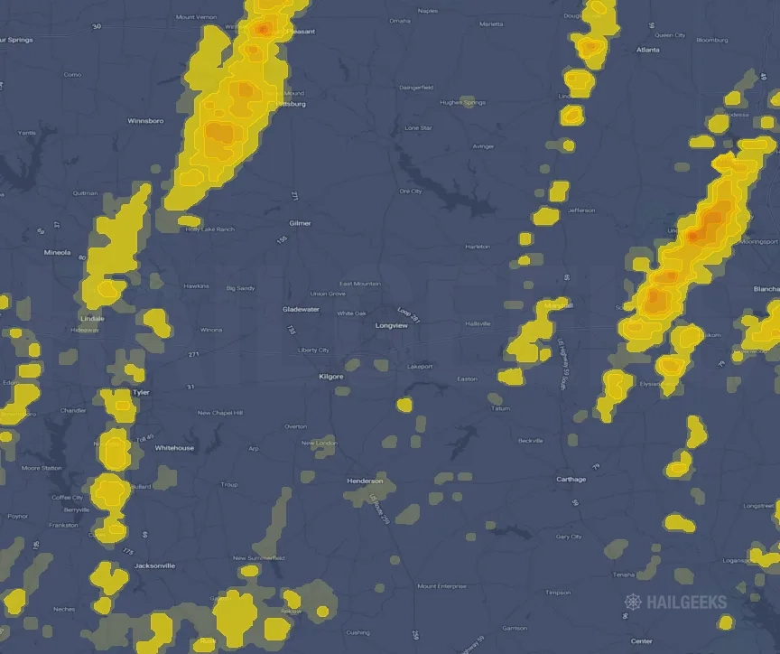
Hail Swath Map Preview
The Longview, TX hail swath map preview was last reviewed on August 29, 2026 and shows mapped hail estimates up to 1.75". There are 5 public hail reports, 8 public wind reports, and 4 nearby tornado reports listed for the May 6, 2025 event.
View the May 6, 2025 Longview, TX hail event on the free interactive hail map, then check a free Hail Report by ZIP to see a more local hail signal for your area.
Impact Area and Population for the Longview, TX Hail Map
The May 6, 2025 hail swath map for Longview, TX covers approximately 1,732 square miles and includes an estimated 106,580 people inside the mapped footprint. The largest mapped area is in the < 0.50" hail band, covering 761 square miles. The highest estimated population exposure is in the < 0.50" hail band with 45,144 people.
| Mapped Hail Band | Impact Area | Population |
|---|---|---|
| < 0.50" | 761 sq mi | 45,144 |
| 0.50-0.75" | 606 sq mi | 41,177 |
| 0.75-1.00" | 207 sq mi | 15,341 |
| 1.00-1.25" | 100 sq mi | 3,664 |
| 1.25-1.50" | 44 sq mi | 958 |
| 1.50-1.75" | 12 sq mi | 216 |
| 1.75-2.00" | 3 sq mi | 80 |
Get a free Hail Report by ZIP to see a more local hail signal and whether the May 6, 2025 Longview, TX hail event may have reached your area.
Housing Exposure Inside the Longview, TX Hail Swath Map
Inside the May 6, 2025 hail swath map area for Longview, TX, HailGeeks estimates 50,071 single-family homes, 1,005 townhomes, and 11,949 multifamily properties within the mapped storm footprint. Single-family-home exposure is highest in the < 0.50" hail band, with 21,249 single-family homes.
| Mapped Hail Band | Single-Family | Townhomes | Multifamily |
|---|---|---|---|
| < 0.50" | 21,249 | 543 | 4,831 |
| 0.50-0.75" | 19,429 | 386 | 5,588 |
| 0.75-1.00" | 7,187 | 51 | 1,039 |
| 1.00-1.25" | 1,636 | 18 | 379 |
| 1.25-1.50" | 433 | 6 | 89 |
| 1.50-1.75" | 97 | 1 | 14 |
| 1.75-2.00" | 40 | 0 | 9 |
Use this table to review housing exposure by hail band for the May 6, 2025 Longview, TX hail map. To check a specific property more closely, use a free Hail Report by Address.
Counties Inside the Longview, TX Hail Map
Hail from the May 6, 2025 storm was mapped across 24 counties in the Longview, TX region. Harrison County, TX had the strongest mapped signal, peaking at 1.75" with roughly 5,075 single-family homes inside the swath.
County pages group every mapped hail event in the area. For a closer look, drop to the city or ZIP level below, or run a free Hail Report by Address.
Cities Inside the Longview, TX Hail Map
Zooming in, the swath touched 25 cities near Longview, TX. Mount Pleasant, TX had the strongest mapped signal at 1.50", with an estimated 2,762 single-family homes exposed.
City cards show where the May 6, 2025 Longview, TX hail activity was mapped, but your ZIP can show a closer local signal. Get a free Hail Report by ZIP, and if the signal looks meaningful, ask a local pro about a Remote Hail Inspection to see whether an on-site roof or exterior review may be worth scheduling.
ZIP Codes Inside the Longview, TX Hail Swath Map
At the ZIP level, the May 6, 2025 Longview, TX hail map spans 63 ZIP codes. ZIP 75455 shows the strongest local signal, with mapped hail estimates up to 1.75" and an estimated single-family-home exposure of 3,707.
Check your ZIP in seconds to see whether hail activity from the May 6, 2025 Longview, TX event was mapped near your area.
Public Hail, Wind, and Tornado Reports
Public storm report tables connected to the May 6, 2025 hail map for Longview, TX currently list 5 public hail reports, 8 public wind reports, and 4 tornado reports.
| Date & Time | Hail Size | City | State | Description |
|---|---|---|---|---|
May 6, 2025 11:38 AM CT |
1.00 in | 1 W Mount Pleasant | TX | DELAYED REPORT (MAY 6... 2025)...A report of hail of at least quarter size... which damaged skylights at a home in Mount Pleasant. |
May 6, 2025 12:45 PM CT |
1.00 in | 4 SE Noonday | TX | Report of quarter sized hail in Flint... TX. |
May 6, 2025 12:52 PM CT |
1.00 in | 3 ESE Noonday | TX | Report of quarter sized hail in Gresham... TX. |
May 6, 2025 12:59 PM CT |
1.25 in | Vivian | LA | Report from mPING: Half Dollar (1.25 in.) in Vivian. |
May 6, 2025 3:23 PM CT |
1.00 in | Waskom | TX | Social media report of quarter sized hail in Waskom. |
| Date & Time | Wind Speed | City | State | Description |
|---|---|---|---|---|
May 6, 2025 1:01 PM CT | 4 SE Alba | TX | Social media report of a tree down in Queen... TX. | |
May 6, 2025 1:28 PM CT | Frankston | TX | Emergency manager reports trees on homes and powerlines down in Frankston. Time estimated by radar. | |
May 6, 2025 1:44 PM CT | 1 E Bullard | TX | Report of multiple trees down on FM 344. | |
May 6, 2025 1:48 PM CT | 1 E Bullard | TX | Corrects previous flash flood report from 1 E Bullard. Report of multiple trees down on a house in the area of Pecan Valley Drive. | |
May 6, 2025 2:38 PM CT | 3 SE Henderson | TX | Report of a tree down on CR 308 near the intersection with FM 840. | |
May 6, 2025 2:40 PM CT | 7 NW Mount Enterprise | TX | Report of a tree down on FM 1798 west of US 259. | |
May 6, 2025 2:40 PM CT | 5 NNE Mount Enterprise | TX | Report of a few trees down on Texas 315 north of FM 95. | |
May 6, 2025 3:23 PM CT | 3 W Keachi | LA | Report of tree down on SR 172 near Blueberry Trail. |
| Date & Time | Rating | City | State | Description |
|---|---|---|---|---|
May 6, 2025 1:26 PM CT | UNK | 2 W Frankston | TX | *** 1 INJ *** An EF-0 tornado started west of the town of Frankston... close to Hwy 175 and Anderson CR 303. Initially the tornado damaged trees at a few homes along Hwy 175. As the tornado moved into town... it continued to cause tree damage... breaking large limbs from trunks and uprooting trees. Some of the limbs and trees fell on homes causing damage to roofs. One tree fell through the end of a home causing a non-life threatening injury. In the town of Frankston... the tornado was rated EF-0 with maximum winds of 85 mph. Many of the uprooted trees occurred in already saturated soils... and this was factored into the final wind speed determination. The tornado continued east of town and was tracked by scattered tree damage along CRs 3051 and 309. The tornado likely dissipated before reaching Lake Palestine. |
May 6, 2025 1:41 PM CT | UNK | 2 WNW Bullard | TX | NWS Storm Survey across southern Smith County... Texas determined that damage was consistent with that of an EF-1 Tornado with peak winds near 93 mph. The tornado uprooted and/or snapped several trees along its near eastward path with the strongest part of the storm near North Houston Street and west of US Hwy. 69 and near a neighborhood just north of Lynch Drive near Bullard... Texas. Several structures along the path of this storm suffered roof damage as well. |
May 6, 2025 2:26 PM CT | UNK | 9 S Greenwood | LA | An EF-1 tornado with estimated maximum winds near 105 mph touched down in Southwest Caddo Parish north of Springridge Texas Line Road and west of Providence Road... and tracked northeast for nearly 13 miles into Southwest Shreveport. Damage consisted primarily of numerous snapped and uprooted trees... with several homes suffering damage from fallen trees on Adams and Sebastian Roads in Southwest Caddo Parish... as well on Lytham Drive and North Heatherstone Drive in the Newcastle subdivision in Southwest Shreveport. The tornado lifted along Mackey Lane shortly before reaching Summer Grove Baptist Church. The tornado maximum path width was 810 yards. |
May 6, 2025 3:33 PM CT | UNK | 6 SE Greenwood | LA | Trees were snapped along Woolworth Road south of Walnut Hill Elementary/Middle School near the entrance to the Caddo Parish landfill. A radar indicated TDS was depicted near this location. |
This table includes only public storm reports connected to the May 6, 2025 Longview, TX storm event. When available, each report may include the time, size or magnitude, city, state, and a short description.
Related Hail Maps in the Longview, TX Region
We found 6 more hail maps with reports from the same Longview, TX region as the May 6, 2025 event. These related maps cover storm dates from Apr 3, 2025 through May 2, 2025, with mapped hail estimates ranging from 0.75" to 2.00". In this set, the strongest related map reached 2.00", and the most recent map shown is from May 2, 2025.


If none of these related Longview, TX hail maps look close enough to your property, check a free Hail Report by Address. It reviews hail history for a specific location — not just the broader Longview, TX region — so you can check whether hail activity may have reached your property.
Local Hail Review Options Near Longview, TX
Not sure whether the May 6, 2025 Longview, TX hail map matters for your property? Start with a free Hail Report by Address to see whether hail activity was mapped for that property. If the property signal looks meaningful, you can choose a local pro serving the Longview, TX region and ask about a Remote Hail Inspection before deciding whether an on-site roof or exterior review is worth scheduling.
Check a specific property to see whether hail activity from the May 6, 2025 Longview, TX event — or another recent hail event — may have been mapped at that address.
Find a roof or exterior pro serving the Longview, TX region who can help you understand what the property hail signal may mean.
A participating local pro reviews property-level hail history remotely — not just the May 6, 2025 event — to help decide whether an on-site inspection may be worth scheduling.
A free Hail Report by Address and a Remote Hail Inspection can help you look beyond the May 6, 2025 hail map visuals alone. They do not confirm property damage and do not replace an on-site inspection for a property in the Longview, TX region, but they can help you make a more informed next decision before anyone climbs on the roof.
Frequently Asked Questions
Common questions about the May 6, 2025 Longview, TX hail event.