

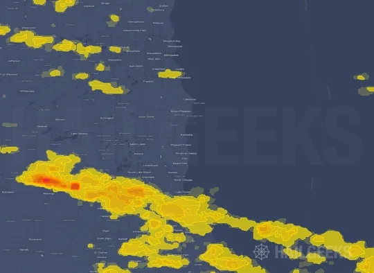
Hail Swath Map Preview
The Kenosha, WI hail swath map preview was last reviewed on August 29, 2026 and shows mapped hail estimates up to 2.25". There are 53 public hail reports, 20 public wind reports, and 1 nearby tornado reports listed for the May 15, 2025 event.
View the May 15, 2025 Kenosha, WI hail event on the free interactive hail map, then check a free Hail Report by ZIP to see a more local hail signal for your area.
Impact Area and Population for the Kenosha, WI Hail Map
The May 15, 2025 hail swath map for Kenosha, WI covers approximately 4,704 square miles and includes an estimated 2,467,360 people inside the mapped footprint. The largest mapped area is in the 0.50-0.75" hail band, covering 1,951 square miles. The highest estimated population exposure is in the 0.50-0.75" hail band with 984,345 people.
| Mapped Hail Band | Impact Area | Population |
|---|---|---|
| < 0.50" | 1,143 sq mi | 472,910 |
| 0.50-0.75" | 1,951 sq mi | 984,345 |
| 0.75-1.00" | 858 sq mi | 456,850 |
| 1.00-1.25" | 414 sq mi | 268,421 |
| 1.25-1.50" | 181 sq mi | 145,748 |
| 1.50-1.75" | 70 sq mi | 106,478 |
| 1.75-2.00" | 50 sq mi | 27,773 |
| 2.00-2.25" | 17 sq mi | 1,843 |
| 2.25-2.50" | 20 sq mi | 2,992 |
Get a free Hail Report by ZIP to see a more local hail signal and whether the May 15, 2025 Kenosha, WI hail event may have reached your area.
Housing Exposure Inside the Kenosha, WI Hail Swath Map
Inside the May 15, 2025 hail swath map area for Kenosha, WI, HailGeeks estimates 631,000 single-family homes, 64,352 townhomes, and 902,045 multifamily properties within the mapped storm footprint. Single-family-home exposure is highest in the 0.50-0.75" hail band, with 267,858 single-family homes.
| Mapped Hail Band | Single-Family | Townhomes | Multifamily |
|---|---|---|---|
| < 0.50" | 125,271 | 14,008 | 166,140 |
| 0.50-0.75" | 267,858 | 25,591 | 353,740 |
| 0.75-1.00" | 120,091 | 12,969 | 153,202 |
| 1.00-1.25" | 63,449 | 5,905 | 100,841 |
| 1.25-1.50" | 23,817 | 2,866 | 73,278 |
| 1.50-1.75" | 18,630 | 1,904 | 48,800 |
| 1.75-2.00" | 9,881 | 1,026 | 5,585 |
| 2.00-2.25" | 815 | 44 | 154 |
| 2.25-2.50" | 1,188 | 39 | 305 |
Use this table to review housing exposure by hail band for the May 15, 2025 Kenosha, WI hail map. To check a specific property more closely, use a free Hail Report by Address.
Counties Inside the Kenosha, WI Hail Map
Hail from the May 15, 2025 storm was mapped across 17 counties in the Kenosha, WI region. Waukesha County, WI had the strongest mapped signal, peaking at 2.25" with roughly 73,857 single-family homes inside the swath.
County pages group every mapped hail event in the area. For a closer look, drop to the city or ZIP level below, or run a free Hail Report by Address.
Cities Inside the Kenosha, WI Hail Map
Zooming in, the swath touched 139 cities near Kenosha, WI. Oconomowoc, WI had the strongest mapped signal at 2.00", with an estimated 5,041 single-family homes exposed.
City cards show where the May 15, 2025 Kenosha, WI hail activity was mapped, but your ZIP can show a closer local signal. Get a free Hail Report by ZIP, and if the signal looks meaningful, ask a local pro about a Remote Hail Inspection to see whether an on-site roof or exterior review may be worth scheduling.
ZIP Codes Inside the Kenosha, WI Hail Swath Map
At the ZIP level, the May 15, 2025 Kenosha, WI hail map spans 179 ZIP codes. ZIP 53066 shows the strongest local signal, with mapped hail estimates up to 2.25" and an estimated single-family-home exposure of 11,857.
Check your ZIP in seconds to see whether hail activity from the May 15, 2025 Kenosha, WI event was mapped near your area.
Public Hail, Wind, and Tornado Reports
Public storm report tables connected to the May 15, 2025 hail map for Kenosha, WI currently list 53 public hail reports, 20 public wind reports, and 1 tornado reports.
| Date & Time | Hail Size | City | State | Description |
|---|---|---|---|---|
May 15, 2025 5:02 PM CT |
1.00 in | 3 SE Palmyra | WI | No National Weather Service description provided. |
May 15, 2025 5:04 PM CT |
1.50 in | Eagle | WI | Pictures of hail to the size of ping pong balls. |
May 15, 2025 5:18 PM CT |
1.50 in | Dousman | WI | Relayed via X with photo. |
May 15, 2025 5:25 PM CT |
1.00 in | 1 W Dousman | WI | No National Weather Service description provided. |
May 15, 2025 5:27 PM CT |
1.00 in | 1 N Wales | WI | Report from mPING: Quarter (1.00 in.). |
May 15, 2025 5:31 PM CT |
1.00 in | 1 NW Nashotah | WI | No National Weather Service description provided. |
May 15, 2025 5:40 PM CT |
1.00 in | 3 S Richfield | WI | No National Weather Service description provided. |
May 15, 2025 5:52 PM CT |
1.00 in | 3 SSE Hubertus | WI | No National Weather Service description provided. |
May 15, 2025 6:00 PM CT |
1.00 in | 1 SW East Troy | WI | Shredded leaves off of trees... did not accumulate much. |
May 15, 2025 6:00 PM CT |
1.50 in | 4 S East Troy | WI | No National Weather Service description provided. |
May 15, 2025 6:03 PM CT |
1.25 in | East Troy | WI | Report from mPING: Half Dollar (1.25 in.). |
May 15, 2025 6:05 PM CT |
1.25 in | Mukwonago | WI | No National Weather Service description provided. |
May 15, 2025 6:06 PM CT |
1.00 in | East Troy | WI | No National Weather Service description provided. |
May 15, 2025 6:08 PM CT |
2.00 in | East Troy | WI | No National Weather Service description provided. |
May 15, 2025 6:08 PM CT |
1.00 in | 1 SE Mukwonago | WI | Report from mPING: Quarter (1.00 in.). |
May 15, 2025 6:13 PM CT |
2.50 in | 4 W Waterford | WI | Tennis-Baseball sized hail causing significant damage to vehicles in far western Waterford near Walworth county border. |
May 15, 2025 6:14 PM CT |
1.75 in | 3 NE Ixonia | WI | Reported by Jefferson County Sheriff near Co Hwy P. |
May 15, 2025 6:14 PM CT |
2.50 in | 1 SE Ixonia | WI | Report from mPING: Tennis Ball (2.50 in.). |
May 15, 2025 6:15 PM CT |
1.00 in | 1 SW Lac La Belle | WI | Report from mPING: Quarter (1.00 in.). |
May 15, 2025 6:15 PM CT |
2.00 in | 5 N Lac La Belle | WI | Hail ranging from over 0.5 inch diameter to larger than 2 inch diameter at times... lasted approximately 20 minutes. Wind was generally from the west and south... with strong wind gusts. Damage to vinyl windows. Complete study not completed yet. |
May 15, 2025 6:21 PM CT |
1.00 in | 2 W Waterford | WI | Report from mPING: Quarter (1.00 in.). |
May 15, 2025 6:23 PM CT |
1.00 in | 2 E Hartford | WI | Report from mPING: Quarter (1.00 in.). |
May 15, 2025 6:24 PM CT |
1.25 in | 2 SE Hartford | WI | No National Weather Service description provided. |
May 15, 2025 6:26 PM CT |
2.00 in | 5 W Erin | WI | Report from mPING: Hen Egg (2.00 in.). |
May 15, 2025 6:31 PM CT |
1.00 in | 1 W Belvidere | IL | Public report of quarter size hail in Belvidere. |
May 15, 2025 6:36 PM CT |
1.00 in | 1 N Muskego | WI | No National Weather Service description provided. |
May 15, 2025 6:38 PM CT |
1.00 in | 1 W Muskego | WI | Report from mPING: Quarter (1.00 in.). |
May 15, 2025 6:40 PM CT |
1.50 in | 1 W Hales Corners | WI | Report from mPING: Ping Pong Ball (1.50 in.). |
May 15, 2025 6:40 PM CT |
1.00 in | 1 WNW Park City | IL | Trained spotter reported quarter size hail on the south side of Gurnee. Time estimated by radar. |
May 15, 2025 6:41 PM CT |
1.00 in | 2 SW Hales Corners | WI | Report from mPING: Quarter (1.00 in.). |
May 15, 2025 6:41 PM CT |
1.75 in | 1 W Waukegan | IL | No National Weather Service description provided. |
May 15, 2025 6:42 PM CT |
1.00 in | 1 NW Wind Lake | WI | Report from mPING: Quarter (1.00 in.). |
May 15, 2025 6:42 PM CT |
2.00 in | Big Bend | WI | Largest measured. |
May 15, 2025 6:42 PM CT |
2.00 in | Gurnee | IL | Trained spotter reported 2 inch hail on the west side of Gurnee. |
May 15, 2025 6:44 PM CT |
1.00 in | 1 NE Waukegan | IL | Public report of quarter size hail in northern Waukegan. |
May 15, 2025 6:45 PM CT |
1.00 in | 1 SE West Allis | WI | Report from mPING: Quarter (1.00 in.). |
May 15, 2025 6:47 PM CT |
1.75 in | 2 NE Pleasant Prairie | WI | No National Weather Service description provided. |
May 15, 2025 6:50 PM CT |
1.00 in | Kenosha | WI | No National Weather Service description provided. |
May 15, 2025 6:50 PM CT |
1.25 in | 1 N Pleasant Prairie | WI | Half dollar size hail on the south side of town. |
May 15, 2025 6:50 PM CT |
1.00 in | 2 WNW Zion | IL | Public report of quarter size hail on the west side of Zion. Time estimated by radar. |
May 15, 2025 6:51 PM CT |
1.00 in | 1 NW Kenosha | WI | Report from mPING: Quarter (1.00 in.). |
May 15, 2025 6:53 PM CT |
2.00 in | 3 NNW Kenosha | WI | Picture of 2 inch hail. |
May 15, 2025 6:54 PM CT |
1.00 in | 1 S Greendale | WI | Report from mPING: Quarter (1.00 in.). |
May 15, 2025 6:54 PM CT |
2.00 in | Winthrop Harbor | IL | Multiple public reports of hail up to 2 inches in diameter in Winthrop Harbor. |
May 15, 2025 6:55 PM CT |
1.75 in | Winthrop Harbor | IL | Public report of golf ball size hail near Winthrop Harbor. Relayed via mping. |
May 15, 2025 6:58 PM CT |
1.25 in | 1 N Pleasant Prairie | WI | Report from mPING: Half Dollar (1.25 in.). |
May 15, 2025 7:00 PM CT |
1.25 in | 2 E Elmwood Park | WI | Report from mPING: Half Dollar (1.25 in.). |
May 15, 2025 7:00 PM CT |
1.25 in | 1 S Racine | WI | Downtown Racine. |
May 15, 2025 7:01 PM CT |
1.00 in | 1 E Oak Creek | WI | Report from mPING: Quarter (1.00 in.). |
May 15, 2025 7:01 PM CT |
1.00 in | 3 SE Oak Creek | WI | Report from mPING: Quarter (1.00 in.). |
May 15, 2025 7:01 PM CT |
1.00 in | 1 S South Milwaukee | WI | No National Weather Service description provided. |
May 15, 2025 7:05 PM CT |
1.75 in | 3 SE Oak Creek | WI | Report from mPING: Golf Ball (1.75 in.). |
May 15, 2025 7:20 PM CT |
1.00 in | 1 NW Wind Point | WI | Report from mPING: Quarter (1.00 in.). |
| Date & Time | Wind Speed | City | State | Description |
|---|---|---|---|---|
May 15, 2025 5:31 PM CT | 4 SW Union Grove | WI | Public report of large tree branches down and fencing blown down in the Brighton Dale Golf Course area. Time estimated by radar. | |
May 15, 2025 5:33 PM CT | Lowell | WI | Multiple uprooted trees. Time estimated from radar. | |
May 15, 2025 6:23 PM CT | 1 N Lakemoor | IL | Public report of tree damage between McHenry and Volo. Time estimated by radar. | |
May 15, 2025 6:25 PM CT | Vernon Hills | IL | Public report of small branches broken in Vernon Hills. Time estimated by radar. | |
May 15, 2025 6:31 PM CT | Lake Catherine | IL | Pictures received of a large tree down on a home causing damage to the siding on the back of the home in addition to the gutters and part of the roof. Time estimated from radar. | |
May 15, 2025 6:36 PM CT | 1 W Dekalb | IL | Several photos relayed via social media of tree damage in and around DeKalb. One photo showed a 1 foot in diameter tree snapped midway up. Live webcams at the time the storm moved through showed considerable blowing dust as well as several gustnadoes. Time estimated by radar. | |
May 15, 2025 6:37 PM CT | 1 S Antioch | IL | Corrects previous storm surge report from 1 S Antioch. Trained spotter reports estimated 2.5 foot diameter tree broken and has fallen onto house. Time estimated by radar. | |
May 15, 2025 6:41 PM CT | 1 WSW Kingston | IL | Trained spotter reports 16 inch diameter tree broken west of Kingston. Time estimated by radar. | |
May 15, 2025 6:54 PM CT | Wauwatosa | WI | Multiple calls for wires down and some tree damage. No significant damage. | |
May 15, 2025 7:00 PM CT | Wind Point | WI | Trained storm spotter reported multiple trees down and broken branches up to 12 inches in diameter. Time estimated by radar. | |
May 15, 2025 7:00 PM CT | 2 S Racine | WI | Power lines down... uprooted and snapped trees. Hail damage to siding. | |
May 15, 2025 7:00 PM CT | 3 S Union Grove | WI | 2 power poles down in Paris. Time estimated from radar. Reports of individual trees down scattered across Kenosha county. | |
May 15, 2025 7:00 PM CT | 4 ESE Bohners Lake | WI | Several large trees damaged and another tree down on wires in the town of Wheatland. Shed... barn and playset damaged one mile north. Time estimated from radar. | |
May 15, 2025 6:40 PM CT | 59 mph | 4 N Sycamore | IL | Private weather station reported 59 mph gust north of Sycamore. |
May 15, 2025 6:40 PM CT | 67 mph | 2 ENE Genoa | IL | Trained spotter reports measured 67 mph gust east of Genoa. |
May 15, 2025 6:45 PM CT | 65 mph | 5 NW Marengo | IL | IL-DOT weather station north of Marengo reported 65 mph gust. |
May 15, 2025 6:57 PM CT | 58 mph | Wonder Lake | IL | Private weather station reported 58 mph gust near Wonder Lake. |
May 15, 2025 7:03 PM CT | 60 mph | 2 W North Bay | WI | Batten International Airport in Racine. |
May 15, 2025 7:05 PM CT | 61 mph | 2 SW Saint Francis | WI | Last ASOS observation before power went out for contract observer at General Mitchell International Airport. |
May 15, 2025 7:20 PM CT | 61 mph | 3 NE Navy Pier | IL | Harrison Dever Crib reported 61 mph gust. |
| Date & Time | Rating | City | State | Description |
|---|---|---|---|---|
May 15, 2025 5:32 PM CT | UNK | 2 NNW Reeseville | WI | A NWS storm survey found EF-1 rated damage from a tornado that began west of Lowell. This tornado was on the ground for approximately 6.7 miles... ending just south of Oak Grove. Peak wind speeds were estimated to be 90 MPH. |
This table includes only public storm reports connected to the May 15, 2025 Kenosha, WI storm event. When available, each report may include the time, size or magnitude, city, state, and a short description.
Related Hail Maps in the Kenosha, WI Region
We found 6 more hail maps with reports from the same Kenosha, WI region as the May 15, 2025 event. These related maps cover storm dates from Aug 5, 2024 through Apr 18, 2025, with mapped hail estimates ranging from 0.75" to 2.75". In this set, the strongest related map reached 2.75", and the most recent map shown is from Apr 18, 2025.




If none of these related Kenosha, WI hail maps look close enough to your property, check a free Hail Report by Address. It reviews hail history for a specific location — not just the broader Kenosha, WI region — so you can check whether hail activity may have reached your property.
Local Hail Review Options Near Kenosha, WI
Not sure whether the May 15, 2025 Kenosha, WI hail map matters for your property? Start with a free Hail Report by Address to see whether hail activity was mapped for that property. If the property signal looks meaningful, you can choose a local pro serving the Kenosha, WI region and ask about a Remote Hail Inspection before deciding whether an on-site roof or exterior review is worth scheduling.
Check a specific property to see whether hail activity from the May 15, 2025 Kenosha, WI event — or another recent hail event — may have been mapped at that address.
Find a roof or exterior pro serving the Kenosha, WI region who can help you understand what the property hail signal may mean.
A participating local pro reviews property-level hail history remotely — not just the May 15, 2025 event — to help decide whether an on-site inspection may be worth scheduling.
A free Hail Report by Address and a Remote Hail Inspection can help you look beyond the May 15, 2025 hail map visuals alone. They do not confirm property damage and do not replace an on-site inspection for a property in the Kenosha, WI region, but they can help you make a more informed next decision before anyone climbs on the roof.
Frequently Asked Questions
Common questions about the May 15, 2025 Kenosha, WI hail event.