
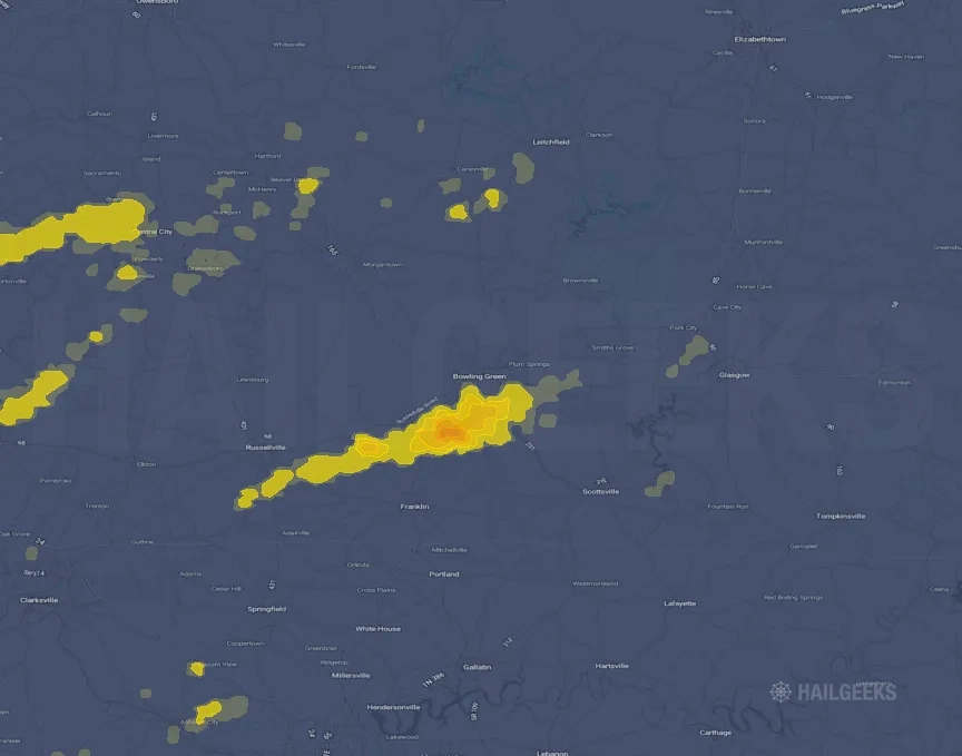
Hail Swath Map Preview
The Bowling Green, KY hail swath map preview was last reviewed on August 29, 2026 and shows mapped hail estimates up to 1.50". There are 1 public hail reports, 23 public wind reports, and 5 nearby tornado reports listed for the May 20, 2025 event.
View the May 20, 2025 Bowling Green, KY hail event on the free interactive hail map, then check a free Hail Report by ZIP to see a more local hail signal for your area.
Impact Area and Population for the Bowling Green, KY Hail Map
The May 20, 2025 hail swath map for Bowling Green, KY covers approximately 453 square miles and includes an estimated 65,129 people inside the mapped footprint. The largest mapped area is in the < 0.50" hail band, covering 246 square miles. The highest estimated population exposure is in the < 0.50" hail band with 24,972 people.
| Mapped Hail Band | Impact Area | Population |
|---|---|---|
| < 0.50" | 246 sq mi | 24,972 |
| 0.50-0.75" | 147 sq mi | 19,549 |
| 0.75-1.00" | 29 sq mi | 10,819 |
| 1.00-1.25" | 22 sq mi | 9,379 |
| 1.25-1.50" | 7 sq mi | 268 |
| 1.50-1.75" | 3 sq mi | 142 |
Get a free Hail Report by ZIP to see a more local hail signal and whether the May 20, 2025 Bowling Green, KY hail event may have reached your area.
Housing Exposure Inside the Bowling Green, KY Hail Swath Map
Inside the May 20, 2025 hail swath map area for Bowling Green, KY, HailGeeks estimates 26,061 single-family homes, 753 townhomes, and 9,104 multifamily properties within the mapped storm footprint. Single-family-home exposure is highest in the < 0.50" hail band, with 10,208 single-family homes.
| Mapped Hail Band | Single-Family | Townhomes | Multifamily |
|---|---|---|---|
| < 0.50" | 10,208 | 183 | 2,578 |
| 0.50-0.75" | 7,267 | 243 | 4,216 |
| 0.75-1.00" | 4,492 | 176 | 1,565 |
| 1.00-1.25" | 3,879 | 145 | 736 |
| 1.25-1.50" | 140 | 4 | 6 |
| 1.50-1.75" | 75 | 2 | 3 |
Use this table to review housing exposure by hail band for the May 20, 2025 Bowling Green, KY hail map. To check a specific property more closely, use a free Hail Report by Address.
Counties Inside the Bowling Green, KY Hail Map
Hail from the May 20, 2025 storm was mapped across 15 counties in the Bowling Green, KY region. Warren County, KY had the strongest mapped signal, peaking at 1.50" with roughly 16,094 single-family homes inside the swath.
County pages group every mapped hail event in the area. For a closer look, drop to the city or ZIP level below, or run a free Hail Report by Address.
Cities Inside the Bowling Green, KY Hail Map
Zooming in, the swath touched 8 cities near Bowling Green, KY. Bowling Green, KY had the strongest mapped signal at 1.00", with an estimated 9,018 single-family homes exposed.
City cards show where the May 20, 2025 Bowling Green, KY hail activity was mapped, but your ZIP can show a closer local signal. Get a free Hail Report by ZIP, and if the signal looks meaningful, ask a local pro about a Remote Hail Inspection to see whether an on-site roof or exterior review may be worth scheduling.
ZIP Codes Inside the Bowling Green, KY Hail Swath Map
At the ZIP level, the May 20, 2025 Bowling Green, KY hail map spans 21 ZIP codes. ZIP 42104 shows the strongest local signal, with mapped hail estimates up to 1.50" and an estimated single-family-home exposure of 10,307.
Check your ZIP in seconds to see whether hail activity from the May 20, 2025 Bowling Green, KY event was mapped near your area.
Public Hail, Wind, and Tornado Reports
Public storm report tables connected to the May 20, 2025 hail map for Bowling Green, KY currently list 1 public hail reports, 23 public wind reports, and 5 tornado reports.
| Date & Time | Hail Size | City | State | Description |
|---|---|---|---|---|
May 20, 2025 5:41 PM CT |
1.00 in | 3 SW Coopertown | TN | Report from mPING: Quarter (1.00 in.). |
| Date & Time | Wind Speed | City | State | Description |
|---|---|---|---|---|
May 20, 2025 4:59 PM CT | 5 N Adairville | KY | Trees down north of Adairville. | |
May 20, 2025 5:00 PM CT | 6 WSW Corinth | KY | Delayed report. A roof blown off a barn... power poles down... and a few trees down in Oakville community. | |
May 20, 2025 5:02 PM CT | 6 WNW Greenville | KY | Several trees down in Graham. | |
May 20, 2025 5:15 PM CT | Adams | TN | 643 customers without power in Adams. | |
May 20, 2025 5:33 PM CT | 3 WSW Plano | KY | Tree down blocking Matlock Rd near Rich Pond Rd. | |
May 20, 2025 5:43 PM CT | 3 NNE South Hill | KY | Tree and a powerline down in the road. Provo Road. Time estimated from radar. | |
May 20, 2025 5:45 PM CT | 3 NE Aberdeen | KY | Tree all the way across the road on McKendree Chapel Rd. Time estimated from radar. | |
May 20, 2025 5:49 PM CT | Caneyville | KY | Tree down in Caneyville. Time estimated from radar. | |
May 20, 2025 5:50 PM CT | 8 SW Ridgetop | TN | Tree down on home in the Joelton area. Time estimated by radar. | |
May 20, 2025 5:51 PM CT | 1 SSE Peonia | KY | Tree down at the intersection of Decker Road and Peonia Road. | |
May 20, 2025 5:52 PM CT | 4 NNE Aberdeen | KY | Tree in road at 4011 Caneyville Road. Time estimated from radar. | |
May 20, 2025 5:54 PM CT | 5 WSW Sugar Grove | KY | Tree down in the roadway at 415 Caney Fork Road. Time Estimated from radar. | |
May 20, 2025 5:55 PM CT | 2 SSE Bon Ayr | KY | Metal building in road way. Time estimated from radar. | |
May 20, 2025 5:55 PM CT | Cross Plains | TN | Large tree down at Highway 25 east at Cedar Grove in Cross Plains blocking the road. Time estimated from radar. | |
May 20, 2025 5:56 PM CT | 2 SW Woodbury | KY | TREE DOWN ACROSS LANE ON 23 MILE MARKER SOUTHBOUND. | |
May 20, 2025 5:56 PM CT | 1 ESE Goodlettsville | TN | Tree down on Ellen Drive in Goodlettsville. Time estimated from radar. | |
May 20, 2025 6:06 PM CT | 2 WSW Roundhill | KY | Tree down across the road in the 1600 block of Threlkel Rd. Time estimated from radar. | |
May 20, 2025 6:14 PM CT | 1 WNW Lecta | KY | TREE BLOCKING HALF THE ROAD. | |
May 20, 2025 6:15 PM CT | 2 SW Hiseville | KY | Tree down blocking the road at 641 Crawford Road. Time estimated from radar. | |
May 20, 2025 6:17 PM CT | 2 SSW Meredith | KY | Tree down. Time estimated from radar. | |
May 20, 2025 6:38 PM CT | 2 SSE Tracy | KY | Tree down blocking whole road in the 9000 block of Austin Tracy Rd. Time estimated from radar. | |
May 20, 2025 6:40 PM CT | 3 NE Tracy | KY | Tree down blocking the roadway near Roseville Road and Cooktown Road. Time estimated from radar. | |
May 20, 2025 6:50 PM CT | Upton | KY | Tree down in Upton on the Larue County side. |
| Date & Time | Rating | City | State | Description |
|---|---|---|---|---|
May 20, 2025 9:55 PM CT | UNK | 2 NNW Russellville | KY | NWS storm survey team determined an EF1 tornado with 100 mph winds impacted Logan County on May 16... 2025. The tornado was on the ground for 2.62 miles... reaching a max width of 75 yards. Please see the associated PNS for more details about this tornado. |
May 20, 2025 5:08 PM CT | UNK | 5 NNW Clarksville | TN | A NWS storm survey team determined that an EF-0 tornado occurred in north Clarksville. This tornado touched down along 101st Airborne Division Rd causing minor tree damage. The tornado moved northeast causing minor tree damage in neighborhoods north of Purple Heart Pkwy. Several trees were uprooted... and tree tops were snapped near Britton Springs Rd and Norris Drive. The tornado continued northeast after crossing Highway 41A continuing to snap large tree branches. The tornado lifted north of West Creek Middle School and south of Tiny Town Rd. |
May 20, 2025 5:21 PM CT | UNK | 4 NNW Clarksville | TN | Ongoing tornado... also confirmed by radar. |
May 20, 2025 5:25 PM CT | UNK | 5 N Fredonia | TN | A NWS storm survey team found a EF-0 tornado that occurred in south Clarksville. This tornado touched down along E Old Ashland City Rd causing a few trees to lean or fall down. The tornado moved northeast uprooting and snapping trees and causing minor house damage along streets north of Madison St. The tornado lifted prior to reaching Trough Springs Rd and I-24. |
May 20, 2025 5:28 PM CT | UNK | 5 N Fredonia | TN | Just west of I-24 near SR-76 and HWY-41A. Debris signature on radar. |
This table includes only public storm reports connected to the May 20, 2025 Bowling Green, KY storm event. When available, each report may include the time, size or magnitude, city, state, and a short description.
Related Hail Maps in the Bowling Green, KY Region
We found 6 more hail maps with reports from the same Bowling Green, KY region as the May 20, 2025 event. These related maps cover storm dates from May 2, 2025 through May 19, 2025, with mapped hail estimates ranging from 0.75" to 2.50". In this set, the strongest related map reached 2.50", and the most recent map shown is from May 19, 2025.


If none of these related Bowling Green, KY hail maps look close enough to your property, check a free Hail Report by Address. It reviews hail history for a specific location — not just the broader Bowling Green, KY region — so you can check whether hail activity may have reached your property.
Local Hail Review Options Near Bowling Green, KY
Not sure whether the May 20, 2025 Bowling Green, KY hail map matters for your property? Start with a free Hail Report by Address to see whether hail activity was mapped for that property. If the property signal looks meaningful, you can choose a local pro serving the Bowling Green, KY region and ask about a Remote Hail Inspection before deciding whether an on-site roof or exterior review is worth scheduling.
Check a specific property to see whether hail activity from the May 20, 2025 Bowling Green, KY event — or another recent hail event — may have been mapped at that address.
Find a roof or exterior pro serving the Bowling Green, KY region who can help you understand what the property hail signal may mean.
A participating local pro reviews property-level hail history remotely — not just the May 20, 2025 event — to help decide whether an on-site inspection may be worth scheduling.
A free Hail Report by Address and a Remote Hail Inspection can help you look beyond the May 20, 2025 hail map visuals alone. They do not confirm property damage and do not replace an on-site inspection for a property in the Bowling Green, KY region, but they can help you make a more informed next decision before anyone climbs on the roof.
Frequently Asked Questions
Common questions about the May 20, 2025 Bowling Green, KY hail event.