

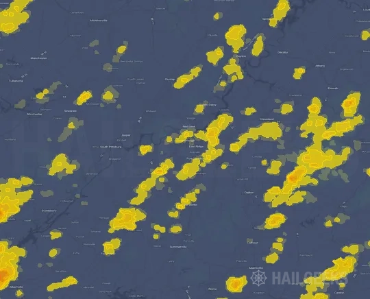
Hail Swath Map Preview
The Chattanooga, TN hail swath map preview was last reviewed on August 29, 2026 and shows mapped hail estimates up to 0.75". There are 0 public hail reports, 27 public wind reports, and 5 nearby tornado reports listed for the May 25, 2025 event.
View the May 25, 2025 Chattanooga, TN hail event on the free interactive hail map, then check a free Hail Report by ZIP to see a more local hail signal for your area.
Impact Area and Population for the Chattanooga, TN Hail Map
The May 25, 2025 hail swath map for Chattanooga, TN covers approximately 367 square miles and includes an estimated 28,173 people inside the mapped footprint. The largest mapped area is in the < 0.50" hail band, covering 202 square miles. The highest estimated population exposure is in the < 0.50" hail band with 14,045 people.
| Mapped Hail Band | Impact Area | Population |
|---|---|---|
| < 0.50" | 202 sq mi | 14,045 |
| 0.50-0.75" | 141 sq mi | 11,766 |
| 0.75-1.00" | 24 sq mi | 2,362 |
Get a free Hail Report by ZIP to see a more local hail signal and whether the May 25, 2025 Chattanooga, TN hail event may have reached your area.
Housing Exposure Inside the Chattanooga, TN Hail Swath Map
Inside the May 25, 2025 hail swath map area for Chattanooga, TN, HailGeeks estimates 13,274 single-family homes, 256 townhomes, and 1,352 multifamily properties within the mapped storm footprint. Single-family-home exposure is highest in the < 0.50" hail band, with 7,164 single-family homes.
| Mapped Hail Band | Single-Family | Townhomes | Multifamily |
|---|---|---|---|
| < 0.50" | 7,164 | 106 | 753 |
| 0.50-0.75" | 5,126 | 103 | 503 |
| 0.75-1.00" | 984 | 47 | 96 |
Use this table to review housing exposure by hail band for the May 25, 2025 Chattanooga, TN hail map. To check a specific property more closely, use a free Hail Report by Address.
Counties Inside the Chattanooga, TN Hail Map
Hail from the May 25, 2025 storm was mapped across 12 counties in the Chattanooga, TN region. Bartow County, GA had the strongest mapped signal, peaking at 0.75" with roughly 5,169 single-family homes inside the swath.
County pages group every mapped hail event in the area. For a closer look, drop to the city or ZIP level below, or run a free Hail Report by Address.
Cities Inside the Chattanooga, TN Hail Map
Zooming in, the swath touched 6 cities near Chattanooga, TN. Adairsville, GA had the strongest mapped signal at 0.50", with an estimated 1,535 single-family homes exposed.
City cards show where the May 25, 2025 Chattanooga, TN hail activity was mapped, but your ZIP can show a closer local signal. Get a free Hail Report by ZIP, and if the signal looks meaningful, ask a local pro about a Remote Hail Inspection to see whether an on-site roof or exterior review may be worth scheduling.
ZIP Codes Inside the Chattanooga, TN Hail Swath Map
At the ZIP level, the May 25, 2025 Chattanooga, TN hail map spans 16 ZIP codes. ZIP 30103 shows the strongest local signal, with mapped hail estimates up to 0.75" and an estimated single-family-home exposure of 2,686.
Check your ZIP in seconds to see whether hail activity from the May 25, 2025 Chattanooga, TN event was mapped near your area.
Public Hail, Wind, and Tornado Reports
Public storm report tables connected to the May 25, 2025 hail map for Chattanooga, TN currently list 0 public hail reports, 27 public wind reports, and 5 tornado reports.
| Date & Time | Hail Size | City | State | Description |
|---|---|---|---|---|
| No public hail reports are available for this event. | ||||
| Date & Time | Wind Speed | City | State | Description |
|---|---|---|---|---|
May 25, 2025 4:10 PM CT | 3 N Manchester | TN | Tree down on Woodbury Highway in Manchester. | |
May 25, 2025 4:13 PM CT | 5 E Estill Springs | TN | HAM operator reported a tree down on a house at 2394 Penile Hill Rd in Franklin County TN. | |
May 25, 2025 4:14 PM CT | 3 WSW Estill Springs | TN | EMA reported tree down on powerlines along Little Hurricane Creek Rd in Winchester TN. | |
May 25, 2025 4:26 PM CT | 4 NW Scottsboro | AL | EMA reported a tree down at the intersection of HWY 79 and HWY 35 in Jackson County. | |
May 25, 2025 4:45 PM CT | 4 SW Bridgeport | AL | EMA reported a tree down across the road at 45549 AL HWY 277 in Bridgeport AL. | |
May 25, 2025 4:54 PM CT | 3 E Scottsboro | AL | EMA reported a tree down across the road at 7000 HWY 35 in Scottsboro AL. | |
May 25, 2025 4:55 PM CT | Jasper | TN | Reports of power outages and presumed trees down. | |
May 25, 2025 4:55 PM CT | Jasper | TN | Reports of widespread trees down across the county. | |
May 25, 2025 5:10 PM CT | 2 WNW Morganville | GA | Multiple trees down along 700 block of Dugan Loop in Dade County. | |
May 25, 2025 5:12 PM CT | Morganville | GA | Tree down near intersection of Morganville Ridge Rd and Hwy 11. | |
May 25, 2025 5:22 PM CT | Fort Oglethorpe | GA | Tree down at intersection of Lafayette road and Harker Rd in Fort Oglethorpe. | |
May 25, 2025 5:30 PM CT | 3 WSW Chattanooga | TN | Report of a tree down in Hamilton County. Location unknown. Time approximated by radar. | |
May 25, 2025 5:37 PM CT | 2 NE Lafayette | GA | Tree down on Ringgold road near. | |
May 25, 2025 5:38 PM CT | 1 S Fort Oglethorpe | GA | Tree in roadway near intersection of Glen Kelly Rd and Lafayette Rd just south of Fort Oglethorpe. | |
May 25, 2025 5:40 PM CT | 3 ENE Trion | GA | Multiple Trees down along and near intersection of Mountain View Rd and Spring Creek Rd in Trion. | |
May 25, 2025 5:40 PM CT | 2 W Trion | GA | Tree down near intersection of Trion Teloga Rd and Bankey Ln (Bankey Farm Rd). | |
May 25, 2025 5:40 PM CT | Trion | GA | Numerous reports of tree damage in and around city of Trion. Sunrise Circle and Sunset lane... tree down with powerlines. Davis Rd with multiple trees and powerlines down. 100 block of Myers Ave with tree down. 700 block of Tate Rd with tree on powerlines. 100 block of Cook St tree on road. | |
May 25, 2025 5:40 PM CT | 1 WSW Summerville | GA | Tree blocking roadway near intersection of Roberts St and James St. | |
May 25, 2025 5:45 PM CT | 1 N Summerville | GA | Tree blocking road along 100 block of Apple Blossom Lane. | |
May 25, 2025 5:48 PM CT | 2 NNW Mill Creek | GA | Emergency manager has several reports of tree across roadway near Quarles Rd and Mill Creek Rd SW. | |
May 25, 2025 5:48 PM CT | Subligna | GA | Several trees down along 7600 block of Gore Subligna Rd with car trapped underneath. No injuries. | |
May 25, 2025 5:55 PM CT | 2 NNE Tilton | GA | Tree in roadway along 2700 block of south riverbend road. | |
May 25, 2025 5:55 PM CT | 3 NNW Tilton | GA | Powerlines down along 3000 block of Five Springs Rd. | |
May 25, 2025 6:08 PM CT | 3 NNE Nickelsville | GA | Large tree down blocking roadway at Hwy 255S and Couch Rd. | |
May 25, 2025 6:22 PM CT | 4 NNE Adairsville | GA | Trees down blocking I-75 N two miles south of Buc-ees. | |
May 25, 2025 6:28 PM CT | 5 S Calhoun | GA | Several large trees uprooted... trampoline flipped over. | |
May 25, 2025 6:50 PM CT | 4 WNW White | GA | Trees down at Spring Place Road and Crowe Springs Rd. |
| Date & Time | Rating | City | State | Description |
|---|---|---|---|---|
May 25, 2025 4:01 PM CT | UNK | 6 W Estill Springs | TN | A tornado touched down just east of the Bluegill Grill and Marina... producing sporadic tree damage between Holiday Drive and Awalt Road. The fallen trees missed the Bigfoot statue at the Bigfoot RV and Boat Storage facility located at the end of Awalt Road. At this location... the tornado was approximately 100 yards wide... snapping and uprooting several hardwood trees. Windspeeds at this location were 93 mph... consistent with an EF1 tornado. From here... the tornado continued skipping to the East/Southeast... producing sporadic tree damage along the path on Rock Creek Road and again just after crossing 41A. Several hardwood and softwood trees were snapped and uprooted on Taylor Road. Sporadic tree damage continued north and east of Estill Springs... with several areas of large branches downed along the path. The tornado lifted east of Hwy 41A. |
May 25, 2025 4:34 PM CT | UNK | 8 WNW Stevenson | AL | A survey team from the NWS in Huntsville... AL and Jackson County EMA... has determined that an EF-0 tornado caused damage in northeastern Jackson County. The tornado had maximum estimate winds of 85 mph. The initial damage was observed in the Cave Springs area near County Road 54... where large tree branches were downed as the tornado tracked east-southeast. Additional indicators of tree damage were found near the intersection of County Road 53 and County Road 147. The tornado then progressed along Highway 117 into Stevenson... where trees were observed to be uprooted or had large branches broken. As the primary damage indicators were related to trees... and considering the above-average rainfall experienced in May... the estimated wind speeds were slightly reduced to account for highly saturated ground conditions. |
May 25, 2025 5:40 PM CT | UNK | 3 ENE Trion | GA | Start of an EF-0 tornado that tracked over Taylors Ridge and ended along Gore Sublgna Road in northern Chattooga County. |
May 25, 2025 6:08 PM CT | UNK | 2 SW Oostanaula | GA | Start of an EF-1 tornado that tracked southeast across southern Gordon County. Structural damage occurred to chicken houses and barns... along with multiple trees snapped or uprooted along its path. |
May 25, 2025 6:13 PM CT | UNK | 1 NW Redbud | GA | Start of a very brief EF-0 tornado that only traveled around 1/4 mile but destroyed a barn and snapped multiple trees along its short path in northern Gordon County. |
This table includes only public storm reports connected to the May 25, 2025 Chattanooga, TN storm event. When available, each report may include the time, size or magnitude, city, state, and a short description.
Related Hail Maps in the Chattanooga, TN Region
We found 6 more hail maps with reports from the same Chattanooga, TN region as the May 25, 2025 event. These related maps cover storm dates from Apr 25, 2025 through May 20, 2025, with mapped hail estimates ranging from 0.75" to 1.50". In this set, the strongest related map reached 1.50", and the most recent map shown is from May 20, 2025.



If none of these related Chattanooga, TN hail maps look close enough to your property, check a free Hail Report by Address. It reviews hail history for a specific location — not just the broader Chattanooga, TN region — so you can check whether hail activity may have reached your property.
Local Hail Review Options Near Chattanooga, TN
Not sure whether the May 25, 2025 Chattanooga, TN hail map matters for your property? Start with a free Hail Report by Address to see whether hail activity was mapped for that property. If the property signal looks meaningful, you can choose a local pro serving the Chattanooga, TN region and ask about a Remote Hail Inspection before deciding whether an on-site roof or exterior review is worth scheduling.
Check a specific property to see whether hail activity from the May 25, 2025 Chattanooga, TN event — or another recent hail event — may have been mapped at that address.
Find a roof or exterior pro serving the Chattanooga, TN region who can help you understand what the property hail signal may mean.
A participating local pro reviews property-level hail history remotely — not just the May 25, 2025 event — to help decide whether an on-site inspection may be worth scheduling.
A free Hail Report by Address and a Remote Hail Inspection can help you look beyond the May 25, 2025 hail map visuals alone. They do not confirm property damage and do not replace an on-site inspection for a property in the Chattanooga, TN region, but they can help you make a more informed next decision before anyone climbs on the roof.
Frequently Asked Questions
Common questions about the May 25, 2025 Chattanooga, TN hail event.