

Hail Swath Map Preview
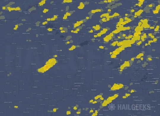
The Janesville, WI hail swath map preview was last reviewed on August 30, 2026 and shows mapped hail estimates up to 2.75". There are 20 public hail reports, 33 public wind reports, and 0 nearby tornado reports listed for the August 16, 2025 event.
View the August 16, 2025 Janesville, WI hail event on the free interactive hail map, then check a free Hail Report by ZIP to see a more local hail signal for your area.
Impact Area and Population for the Janesville, WI Hail Map
The August 16, 2025 hail swath map for Janesville, WI covers approximately 3,519 square miles and includes an estimated 832,224 people inside the mapped footprint. The largest mapped area is in the 0.50-0.75" hail band, covering 1,187 square miles. The highest estimated population exposure is in the 0.50-0.75" hail band with 253,920 people.
| Mapped Hail Band | Impact Area | Population |
|---|---|---|
| < 0.50" | 907 sq mi | 249,269 |
| 0.50-0.75" | 1,187 sq mi | 253,920 |
| 0.75-1.00" | 586 sq mi | 111,970 |
| 1.00-1.25" | 375 sq mi | 73,921 |
| 1.25-1.50" | 200 sq mi | 45,384 |
| 1.50-1.75" | 140 sq mi | 36,489 |
| 1.75-2.00" | 53 sq mi | 21,883 |
| 2.00-2.25" | 32 sq mi | 18,780 |
| 2.25-2.50" | 17 sq mi | 12,023 |
| 2.50-2.75" | 11 sq mi | 7,219 |
| 2.75-3.00" | 10 sq mi | 1,366 |
Get a free Hail Report by ZIP to see a more local hail signal and whether the August 16, 2025 Janesville, WI hail event may have reached your area.
Housing Exposure Inside the Janesville, WI Hail Swath Map
Inside the August 16, 2025 hail swath map area for Janesville, WI, HailGeeks estimates 319,732 single-family homes, 37,586 townhomes, and 98,415 multifamily properties within the mapped storm footprint. Single-family-home exposure is highest in the 0.50-0.75" hail band, with 100,150 single-family homes.
| Mapped Hail Band | Single-Family | Townhomes | Multifamily |
|---|---|---|---|
| < 0.50" | 93,273 | 12,439 | 30,870 |
| 0.50-0.75" | 100,150 | 10,841 | 28,451 |
| 0.75-1.00" | 43,724 | 4,266 | 11,662 |
| 1.00-1.25" | 25,388 | 3,479 | 11,925 |
| 1.25-1.50" | 17,632 | 2,270 | 5,482 |
| 1.50-1.75" | 14,472 | 1,873 | 4,306 |
| 1.75-2.00" | 9,212 | 756 | 2,729 |
| 2.00-2.25" | 7,533 | 718 | 1,436 |
| 2.25-2.50" | 4,901 | 495 | 762 |
| 2.50-2.75" | 2,856 | 405 | 749 |
| 2.75-3.00" | 591 | 44 | 43 |
Use this table to review housing exposure by hail band for the August 16, 2025 Janesville, WI hail map. To check a specific property more closely, use a free Hail Report by Address.
Counties Inside the Janesville, WI Hail Map
Hail from the August 16, 2025 storm was mapped across 27 counties in the Janesville, WI region. Rock County, WI had the strongest mapped signal, peaking at 2.75" with roughly 42,551 single-family homes inside the swath.
County pages group every mapped hail event in the area. For a closer look, drop to the city or ZIP level below, or run a free Hail Report by Address.
Cities Inside the Janesville, WI Hail Map
Zooming in, the swath touched 138 cities near Janesville, WI. Janesville, WI had the strongest mapped signal at 2.50", with an estimated 18,593 single-family homes exposed.
City cards show where the August 16, 2025 Janesville, WI hail activity was mapped, but your ZIP can show a closer local signal. Get a free Hail Report by ZIP, and if the signal looks meaningful, ask a local pro about a Remote Hail Inspection to see whether an on-site roof or exterior review may be worth scheduling.
ZIP Codes Inside the Janesville, WI Hail Swath Map
At the ZIP level, the August 16, 2025 Janesville, WI hail map spans 160 ZIP codes. ZIP 53545 shows the strongest local signal, with mapped hail estimates up to 2.75" and an estimated single-family-home exposure of 7,309.
Check your ZIP in seconds to see whether hail activity from the August 16, 2025 Janesville, WI event was mapped near your area.
Public Hail, Wind, and Tornado Reports
Public storm report tables connected to the August 16, 2025 hail map for Janesville, WI currently list 20 public hail reports, 33 public wind reports, and 0 tornado reports.
| Date & Time | Hail Size | City | State | Description |
|---|---|---|---|---|
August 16, 2025 1:12 PM CT |
1.00 in | 4 NE Cross Plains | WI | Report from mPING: Quarter (1.00 in.). |
August 16, 2025 1:51 PM CT |
1.00 in | 1 S Oregon | WI | Report from mPING: Quarter (1.00 in.). |
August 16, 2025 2:20 PM CT |
1.50 in | 2 W Janesville | WI | Social media report from local storm chaser of the size of ping pong balls on the west side of Janesville. Time estimated from radar. |
August 16, 2025 2:20 PM CT |
1.00 in | 2 NW Janesville | WI | Report from mPING: Quarter (1.00 in.). |
August 16, 2025 2:21 PM CT |
1.00 in | 3 SW Janesville | WI | Report from mPING: Quarter (1.00 in.). |
August 16, 2025 2:22 PM CT |
1.00 in | 1 NNW Janesville | WI | Public Facebook report via video of many hailstones shredding leaves off a backyard tree; size estimated. Time estimated by radar. |
August 16, 2025 2:25 PM CT |
1.00 in | 3 NE Janesville | WI | Report from mPING: Quarter (1.00 in.). |
August 16, 2025 2:40 PM CT |
1.50 in | 1 N Clinton | WI | Image of ping-pong ball sized hail from a social media report... with a quarter for scale. |
August 16, 2025 2:40 PM CT |
1.00 in | Clinton | WI | Report from mPING: Quarter (1.00 in.). |
August 16, 2025 3:51 PM CT |
1.00 in | Woodstock | IL | Relayed via mping. |
August 16, 2025 3:51 PM CT |
1.00 in | 2 SE Belvidere | IL | Relayed via mping. |
August 16, 2025 3:54 PM CT |
1.00 in | 1 NW Belvidere | IL | Report from mPING: Quarter (1.00 in.). |
August 16, 2025 4:04 PM CT |
1.50 in | 1 SW Port Barrington | IL | Relayed via mping. |
August 16, 2025 4:05 PM CT |
1.25 in | Cary | IL | Relayed via mping. |
August 16, 2025 4:25 PM CT |
1.25 in | 1 E Palatine | IL | No National Weather Service description provided. |
August 16, 2025 4:28 PM CT |
1.00 in | Rolling Meadows | IL | Harper College. Multiple large branches also broken. |
August 16, 2025 4:33 PM CT |
1.00 in | Arlington Heights | IL | 1333 Chicago Ave. |
August 16, 2025 7:19 PM CT |
1.00 in | Winslow | IL | No National Weather Service description provided. |
August 16, 2025 7:24 PM CT |
2.00 in | 2 NW Winslow | WI | Report from mPING: Hen Egg (2.00 in.). |
August 16, 2025 7:33 PM CT |
3.00 in | 1 N Winslow | IL | Report from mPING. This report was corroborated with photographic evidence of a jagged hailstone around 3 to 3.5 inches in diameter. |
| Date & Time | Wind Speed | City | State | Description |
|---|---|---|---|---|
August 16, 2025 2:20 PM CT | Janesville | WI | Dispatch reports tree damage across Janesville. | |
August 16, 2025 3:40 PM CT | 1 N Woodstock | IL | Tree on a house along Clay Street in Woodstock. Time estimated by radar. | |
August 16, 2025 3:40 PM CT | Belvidere | IL | Seven trees down at the corner of Whitney Blvd and 2nd Street... the largest 4 feet in diameter. Power lines also down. | |
August 16, 2025 3:40 PM CT | Belvidere | IL | 3-4 foot diameter trees snapped on North Appleton Rd between Douglas and Maryland. Time estimated by radar. | |
August 16, 2025 3:42 PM CT | 1 SE Belvidere | IL | Boone County EM reports numerous trees down along the southeast side of town. Time estimated by radar. | |
August 16, 2025 3:45 PM CT | Woodstock | IL | Woodstock Police Department reports multiple power lines downed in Woodstock. Relayed by McHenry County EMA. Time estimated by radar. | |
August 16, 2025 3:47 PM CT | 1 N Belvidere | IL | 6-12 inch diameter branches broken near Jackson and Gardner in Belvidere. | |
August 16, 2025 3:47 PM CT | 2 NW Trout Valley | IL | Numerous trees down... some into powerlines and on cars. Time estimated by radar. | |
August 16, 2025 3:50 PM CT | 1 N Belvidere | IL | Updated report. Two two-foot diameter trees downed near Jackson and Gardner in Belvidere. Time estimated by radar. | |
August 16, 2025 3:51 PM CT | 1 ESE Algonquin | IL | Tree down on 3 cars on Webster street near rt 62 and 31. Time estimated by radar. | |
August 16, 2025 3:51 PM CT | 1 NNE Algonquin | IL | Photo shared to social media shows large branched broken from tops of trees near Main Street and Cary Road in Algonquin. Time estimated by radar. | |
August 16, 2025 3:58 PM CT | 2 S Algonquin | IL | Tree down on Woodcrest Lane. Time Estimated. | |
August 16, 2025 4:00 PM CT | Fox River Grove | IL | Photos showed numerous trees and tree limbs blown down from Lions Park through the Foxmoor Subdivision. Some trees were uprooted. | |
August 16, 2025 4:00 PM CT | 1 E Wayne | IL | Many large trees uprooted... large branches broken... and parts of corn fields flattened near Oak Lawn Farm (roughly Fabian and Kirk Roads). | |
August 16, 2025 4:02 PM CT | 1 N Fox River Grove | IL | Numerous photos shared to social media of large branches broken in and near Cary. At least one tree uprooted. Time estimated by radar. | |
August 16, 2025 4:02 PM CT | 2 NNE Carpentersville | IL | Two large trees were blown down onto County Line Road near the Cook-Kane County border. | |
August 16, 2025 4:02 PM CT | 1 NE Carpentersville | IL | Public report of multiple branches broken from tree near Carpentersville. | |
August 16, 2025 4:04 PM CT | 1 S Sleepy Hollow | IL | Tree blown down into the road near Sleepy Hollow Road and Boncosky Road. Time Estimated. | |
August 16, 2025 4:05 PM CT | 2 NE Barrington Hills | IL | Downed trees... branches... and power lines. Hail of unknown size as well. Time estimated from radar. | |
August 16, 2025 4:06 PM CT | 2 ESE Fox River Grove | IL | Photo shared via social media shows several inch diameter branch broken near Northwest Highway and Kelsey Road. Time estimated by radar. | |
August 16, 2025 4:08 PM CT | 1 N Barrington Hills | IL | Village of Barrington reported via social media that multiple tree branches broken in the area. Public report of large tree branch blocking Oak Knoll Road west of Barrington. Time estimated by radar. | |
August 16, 2025 4:10 PM CT | 2 E Elgin | IL | 1 inch diameter branches broken near Elgin due to thunderstorm outflow. | |
August 16, 2025 4:12 PM CT | 4 NE Lily Lake | IL | Tree down blocking Lenz Road near Muirhead Road. Time Estimated. | |
August 16, 2025 4:21 PM CT | 1 NW Dekalb | IL | Photos depict an uprooted softwood tree and 8 to 12 inch diameter tree limb snapped in the vicinity of Greenbrier Court. Time estimated by radar. | |
August 16, 2025 4:22 PM CT | Bartlett | IL | 1 ft diameter tree snapped at Spaulding and Stroger. | |
August 16, 2025 4:23 PM CT | Hoffman Estates | IL | Several tree limbs 8 to 12 inches in diameter were blown down near Mundhank Road and South Freeman Road. | |
August 16, 2025 4:25 PM CT | 2 SE Palatine | IL | Multiple photos shared to social media show numerous branches broken southeast of Palatine. Most branches at least multiple inches in diameter. At least one tree trunk split and another tree uprooted. Time estimated by radar. | |
August 16, 2025 4:26 PM CT | 2 NE Dekalb | IL | Photo shared to social media shows large tree branch broken between Dekalb and sycamore. Time estimated by radar. | |
August 16, 2025 4:30 PM CT | Rolling Meadows | IL | Photos showed numerous tree limbs blown down on Cardinal Drive. | |
August 16, 2025 4:30 PM CT | Schaumburg | IL | Photos and videos shared to social media show few inch diameter branches downed. Rotted tree uprooted or snapped in vicinity. Time estimated by radar. | |
August 16, 2025 5:22 PM CT | 1 SW Arlington Heights | IL | Public report of a large tree branch downed in Arlington Heights. | |
August 16, 2025 4:10 PM CT | 65 mph | 4 SW Pingree Grove | IL | near RT 47 and Plato. |
August 16, 2025 4:26 PM CT | 73 mph | 3 NNW Dekalb | IL | No National Weather Service description provided. |
| Date & Time | Rating | City | State | Description |
|---|---|---|---|---|
| No public tornado reports are available for this event. | ||||
This table includes only public storm reports connected to the August 16, 2025 Janesville, WI storm event. When available, each report may include the time, size or magnitude, city, state, and a short description.
Related Hail Maps in the Janesville, WI Region
We found 6 more hail maps with reports from the same Janesville, WI region as the August 16, 2025 event. These related maps cover storm dates from Jul 11, 2025 through Aug 12, 2025, with mapped hail estimates ranging from 0.75" to 1.25". In this set, the strongest related map reached 1.25", and the most recent map shown is from Aug 12, 2025.




If none of these related Janesville, WI hail maps look close enough to your property, check a free Hail Report by Address. It reviews hail history for a specific location — not just the broader Janesville, WI region — so you can check whether hail activity may have reached your property.
Local Hail Review Options Near Janesville, WI
Not sure whether the August 16, 2025 Janesville, WI hail map matters for your property? Start with a free Hail Report by Address to see whether hail activity was mapped for that property. If the property signal looks meaningful, you can choose a local pro serving the Janesville, WI region and ask about a Remote Hail Inspection before deciding whether an on-site roof or exterior review is worth scheduling.
Check a specific property to see whether hail activity from the August 16, 2025 Janesville, WI event — or another recent hail event — may have been mapped at that address.
Find a roof or exterior pro serving the Janesville, WI region who can help you understand what the property hail signal may mean.
A participating local pro reviews property-level hail history remotely — not just the August 16, 2025 event — to help decide whether an on-site inspection may be worth scheduling.
A free Hail Report by Address and a Remote Hail Inspection can help you look beyond the August 16, 2025 hail map visuals alone. They do not confirm property damage and do not replace an on-site inspection for a property in the Janesville, WI region, but they can help you make a more informed next decision before anyone climbs on the roof.
Frequently Asked Questions
Common questions about the August 16, 2025 Janesville, WI hail event.