

Hail Swath Map Preview
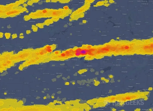
The Madison, WI hail swath map preview was last reviewed on August 30, 2026 and shows mapped hail estimates up to 2.50". There are 46 public hail reports, 10 public wind reports, and 14 nearby tornado reports listed for the April 17, 2026 event.
View the April 17, 2026 Madison, WI hail event on the free interactive hail map, then check a free Hail Report by ZIP to see a more local hail signal for your area.
Impact Area and Population for the Madison, WI Hail Map
The April 17, 2026 hail swath map for Madison, WI covers approximately 3,102 square miles and includes an estimated 300,966 people inside the mapped footprint. The largest mapped area is in the 0.50-0.75" hail band, covering 924 square miles. The highest estimated population exposure is in the 0.50-0.75" hail band with 65,089 people.
| Mapped Hail Band | Impact Area | Population |
|---|---|---|
| < 0.50" | 726 sq mi | 60,118 |
| 0.50-0.75" | 924 sq mi | 65,089 |
| 0.75-1.00" | 602 sq mi | 49,260 |
| 1.00-1.25" | 430 sq mi | 49,720 |
| 1.25-1.50" | 230 sq mi | 44,693 |
| 1.50-1.75" | 111 sq mi | 21,009 |
| 1.75-2.00" | 42 sq mi | 3,771 |
| 2.00-2.25" | 20 sq mi | 3,496 |
| 2.25-2.50" | 8 sq mi | 3,542 |
| 2.50-2.75" | 10 sq mi | 268 |
Get a free Hail Report by ZIP to see a more local hail signal and whether the April 17, 2026 Madison, WI hail event may have reached your area.
Housing Exposure Inside the Madison, WI Hail Swath Map
Inside the April 17, 2026 hail swath map area for Madison, WI, HailGeeks estimates 130,589 single-family homes, 7,751 townhomes, and 32,163 multifamily properties within the mapped storm footprint. Single-family-home exposure is highest in the < 0.50" hail band, with 26,350 single-family homes.
| Mapped Hail Band | Single-Family | Townhomes | Multifamily |
|---|---|---|---|
| < 0.50" | 26,350 | 1,743 | 5,810 |
| 0.50-0.75" | 25,279 | 1,432 | 6,791 |
| 0.75-1.00" | 21,402 | 1,057 | 5,073 |
| 1.00-1.25" | 23,639 | 1,599 | 4,876 |
| 1.25-1.50" | 19,325 | 1,328 | 5,974 |
| 1.50-1.75" | 9,301 | 438 | 2,222 |
| 1.75-2.00" | 2,043 | 43 | 182 |
| 2.00-2.25" | 1,503 | 72 | 454 |
| 2.25-2.50" | 1,603 | 39 | 773 |
| 2.50-2.75" | 144 | 0 | 8 |
Use this table to review housing exposure by hail band for the April 17, 2026 Madison, WI hail map. To check a specific property more closely, use a free Hail Report by Address.
Counties Inside the Madison, WI Hail Map
Hail from the April 17, 2026 storm was mapped across 24 counties in the Madison, WI region. Stephenson County, IL had the strongest mapped signal, peaking at 2.50" with roughly 5,736 single-family homes inside the swath.
County pages group every mapped hail event in the area. For a closer look, drop to the city or ZIP level below, or run a free Hail Report by Address.
Cities Inside the Madison, WI Hail Map
Zooming in, the swath touched 62 cities near Madison, WI. Dakota, IL had the strongest mapped signal at 2.50", with an estimated 14 single-family homes exposed.
City cards show where the April 17, 2026 Madison, WI hail activity was mapped, but your ZIP can show a closer local signal. Get a free Hail Report by ZIP, and if the signal looks meaningful, ask a local pro about a Remote Hail Inspection to see whether an on-site roof or exterior review may be worth scheduling.
ZIP Codes Inside the Madison, WI Hail Swath Map
At the ZIP level, the April 17, 2026 Madison, WI hail map spans 110 ZIP codes. ZIP 61032 shows the strongest local signal, with mapped hail estimates up to 2.50" and an estimated single-family-home exposure of 727.
Check your ZIP in seconds to see whether hail activity from the April 17, 2026 Madison, WI event was mapped near your area.
Public Hail, Wind, and Tornado Reports
Public storm report tables connected to the April 17, 2026 hail map for Madison, WI currently list 46 public hail reports, 10 public wind reports, and 14 tornado reports.
| Date & Time | Hail Size | City | State | Description |
|---|---|---|---|---|
April 17, 2026 2:51 PM CT |
1.25 in | 1 SE Galena | IL | Report from mPING: Half Dollar (1.25 in.). |
April 17, 2026 2:52 PM CT |
1.50 in | 2 E Galena | IL | Report from mPING: Ping Pong Ball (1.50 in.). |
April 17, 2026 2:54 PM CT |
1.50 in | 2 W Galena Territory | IL | Report from mPING: Ping Pong Ball (1.50 in.). |
April 17, 2026 2:55 PM CT |
1.75 in | 1 S Rice | IL | No National Weather Service description provided. |
April 17, 2026 2:57 PM CT |
1.75 in | 2 S Galena Territory | IL | Report from mPING: Golf Ball (1.75 in.). |
April 17, 2026 2:57 PM CT |
1.75 in | 2 S Galena Territory | IL | Report from mPING: Golf Ball (1.75 in.). |
April 17, 2026 2:59 PM CT |
1.75 in | 2 N Rodden | IL | Report from mPING: Golf Ball (1.75 in.). |
April 17, 2026 3:00 PM CT |
1.00 in | 1 E Galena Territory | IL | Report from mPING: Quarter (1.00 in.). |
April 17, 2026 3:01 PM CT |
1.75 in | 1 E Rodden | IL | Report from mPING: Golf Ball (1.75 in.). |
April 17, 2026 3:13 PM CT |
1.75 in | Elizabeth | IL | No National Weather Service description provided. |
April 17, 2026 3:30 PM CT |
1.25 in | Elizabeth | IL | No National Weather Service description provided. |
April 17, 2026 3:50 PM CT |
1.00 in | 1 S Nora | IL | Time estimated by radar. |
April 17, 2026 4:07 PM CT |
1.00 in | Dodgeville | WI | Time estimated from radar. |
April 17, 2026 4:18 PM CT |
1.75 in | 2 E Rock Grove | IL | Report from mPING: Golf Ball (1.75 in.). |
April 17, 2026 4:24 PM CT |
1.75 in | 1 N Dakota | IL | No National Weather Service description provided. |
April 17, 2026 4:24 PM CT |
3.00 in | 2 W Dakota | IL | Report from mPING: Tea Cup (3.00 in.). |
April 17, 2026 4:25 PM CT |
1.00 in | 3 SW Winneshiek | IL | Report from mPING: Quarter (1.00 in.). |
April 17, 2026 4:26 PM CT |
1.00 in | Winneshiek | IL | Report from mPING: Quarter (1.00 in.). |
April 17, 2026 4:29 PM CT |
1.75 in | Winneshiek | IL | Report from mPING: Golf Ball (1.75 in.). |
April 17, 2026 4:32 PM CT |
1.00 in | 3 NNE Stockton | IL | Photos relayed via social media. |
April 17, 2026 4:38 PM CT |
2.00 in | 2 NNW Pecatonica | IL | Photo shows hail estimated as approximately 2 inches in diameter near Pecatonica. Location estimated... relayed by broadcast media. Time estimated by radar. |
April 17, 2026 4:40 PM CT |
2.00 in | 2 NNE Davis | IL | No National Weather Service description provided. |
April 17, 2026 4:41 PM CT |
2.25 in | 2 NE Lake Summerset | IL | Time estimated by radar. Relayed via mping. |
April 17, 2026 4:41 PM CT |
1.25 in | 2 SW Durand | IL | Report from mPING: Half Dollar (1.25 in.). |
April 17, 2026 4:43 PM CT |
1.75 in | 1 S Durand | IL | Hail of at least golf ball size ongoing on south side of Durand. |
April 17, 2026 4:44 PM CT |
2.25 in | 1 SE Durand | IL | Hen egg size hail south of Durand. Relayed via mping. |
April 17, 2026 4:45 PM CT |
2.75 in | Dakota | IL | report from LOT on Dakota storm.. they received a photo of baseball size hail.. |
April 17, 2026 4:48 PM CT |
1.75 in | 4 NE Durand | IL | Relayed via mping. Time estimated by radar. |
April 17, 2026 5:02 PM CT |
1.00 in | 5 SE Belmont | WI | Report from mPING: Quarter (1.00 in.). |
April 17, 2026 5:06 PM CT |
1.00 in | 3 W Rockton | IL | Relayed via mping. |
April 17, 2026 5:08 PM CT |
1.00 in | 2 N Oneco | WI | Report from mPING: Quarter (1.00 in.). |
April 17, 2026 5:11 PM CT |
1.25 in | 1 N Monroe | WI | Report from mPING: Half Dollar (1.25 in.). |
April 17, 2026 5:14 PM CT |
1.50 in | South Beloit | IL | Relayed via mping. Time estimated by radar. |
April 17, 2026 5:16 PM CT |
1.75 in | Beloit | WI | Relayed from Broadcast Media (WMTV Madison). Time estimated from radar. |
April 17, 2026 5:16 PM CT |
1.25 in | South Beloit | IL | Report from mPING: Half Dollar (1.25 in.). |
April 17, 2026 5:20 PM CT |
1.50 in | 1 S Monroe | WI | No National Weather Service description provided. |
April 17, 2026 5:20 PM CT |
1.50 in | South Beloit | IL | Report from mPING: Ping Pong Ball (1.50 in.). |
April 17, 2026 5:29 PM CT |
2.00 in | 3 E Beloit | WI | No National Weather Service description provided. |
April 17, 2026 5:30 PM CT |
2.75 in | Monroe | WI | Relayed from Broadcast Media (WISC). |
April 17, 2026 5:41 PM CT |
1.00 in | 3 NNW Footville | WI | No National Weather Service description provided. |
April 17, 2026 5:42 PM CT |
1.00 in | Watertown | WI | No National Weather Service description provided. |
April 17, 2026 6:12 PM CT |
1.50 in | 1 WSW Janesville | WI | Time estimated from radar. |
April 17, 2026 6:23 PM CT |
1.75 in | Milton | WI | No National Weather Service description provided. |
April 17, 2026 7:02 PM CT |
1.00 in | 3 SE Palmyra | WI | No National Weather Service description provided. |
April 17, 2026 7:12 PM CT |
1.00 in | Eagle | WI | Relayed from HAM Radio. |
April 17, 2026 7:25 PM CT |
1.00 in | 2 S Eagle | WI | No National Weather Service description provided. |
| Date & Time | Wind Speed | City | State | Description |
|---|---|---|---|---|
April 17, 2026 3:00 PM CT | Galena | IL | Several branches down ranging from 2-4 inches in diameter. Many yard items also displaced. | |
April 17, 2026 3:45 PM CT | Lena | IL | Photos show structural damage to houses. Relayed via social media. Tornado possible. | |
April 17, 2026 3:49 PM CT | 4 NNE Stockton | IL | 3Ft tree down at the base. | |
April 17, 2026 4:42 PM CT | Durand | IL | Several photos passed along of broken windows and damaged siding in and around Durand due to wind-driven hail. | |
April 17, 2026 5:02 PM CT | 3 SSE Shirland | IL | Trained spotter reports damage to a structure near Bates Road and Favor Road southeast of Harrison. Possible tornado. Time estimated by radar. | |
April 17, 2026 5:09 PM CT | 3 SW Rockton | IL | Damage to trees and a structure observed along Owen Center Road southwest of Rockton. Possible tornado. Time estimated by radar. | |
April 17, 2026 5:42 PM CT | 5 NW Watertown | WI | Barn wall blown down in Richwood... WI. | |
April 17, 2026 6:49 PM CT | 5 NNW Pecatonica | IL | Photos passed along depict softwood trees snapped near the intersection of Trask Bridge Road and Best Road. Time estimated by radar. | |
April 17, 2026 7:22 PM CT | East Troy | WI | Social media report of uprooted tree in East Troy... WI. Time estimated on radar. | |
April 17, 2026 3:26 PM CT | 70 mph | 1 SSE Warren | IL | Wind out of the west. |
| Date & Time | Rating | City | State | Description |
|---|---|---|---|---|
April 17, 2026 2:47 PM CT | UNK | 2 ESE Galena Territory | IL | EF1 tornado with max winds speed of 90-95 mph begun just east of the Galena Territories causing damage to the awning of house and sporadic tree damage along its 3.7 mile long path. |
April 17, 2026 3:32 PM CT | UNK | 3 NNE Kent | IL | A high-end EF2... possible multi-vortex... tornado with estimated peak winds around 130 mph started along Highway 20... SW of Lena IL... and tracked through Lena before lifting just SW of McConnell. Extensive damage was noted to trees... with a lot of damage to roofs and siding throughout Lena Illinois. Three houses saw extensive damage... with some walls that collapsed as well. |
April 17, 2026 3:36 PM CT | UNK | 3 NNE Kent | IL | Corrects tornado start time from 3 NNE Kent. A high-end EF2... possible multi-vortex... tornado with estimated peak winds around 130 mph started along Highway 20... SW of Lena IL... and tracked through Lena before lifting just SW of McConnell. Extensive damage was noted to trees... with a lot of damage to roofs and siding throughout Lena Illinois. Three houses saw extensive damage... with some walls that collapsed as well. |
April 17, 2026 4:40 PM CT | UNK | 3 N Pecatonica | IL | Video shows possible brief tornado north of Pecatonica. No known damage. Relayed via social media. |
April 17, 2026 4:59 PM CT | UNK | 4 S Shirland | IL | An NWS damage survey confirmed than a high-end EF-1 tornado with peak winds of 110 mph... path length of 3.74 miles... and maximum width of 125 yards damaged trees and several structures in rural Winnebago County. |
April 17, 2026 4:59 PM CT | UNK | 3 SSE Shirland | IL | Trained spotter reports tornado on the ground just southeast of Harrison. |
April 17, 2026 5:04 PM CT | UNK | 3 ESE Shirland | IL | Multiple photos and videos shared via social media show tornado on the ground between Harrison and Rockton. |
April 17, 2026 6:05 PM CT | UNK | 4 SE Janesville | WI | Multiple reports of a tornado on the ground. |
April 17, 2026 6:05 PM CT | UNK | 4 SE Janesville | WI | NWS Damage Survey concludes an EF-1 tornado occurred with estimated peak winds of 100 mph. The tornado started southwest of Emerald Grove and moved northeastward... taking the roof off of a farm outbuilding... buckling garage doors... and snapping multiple trees before ending near Lake Lorraine. Time estimated from radar. |
April 17, 2026 6:09 PM CT | UNK | 5 ENE Avalon | WI | Snapped and uprooted trees... damage to houses... and sheet metal wrapped around trees near Emerald Grove. Time estimated from radar. |
April 17, 2026 6:09 PM CT | UNK | 1 N Avalon | WI | Corrects previous tornado report from 5 ENE Avalon. Snapped and uprooted trees... damage to houses... and sheet metal wrapped around trees near Emerald Grove. Time estimated from radar. |
April 17, 2026 6:40 PM CT | UNK | 3 NNW Darien | WI | NWS Storm Survey concludes an EF-1 tornado occurred with estimated peak winds of 100 mph. The tornado started just north of School Section Road... traveled along State Road 11 into the Redwood Court neighborhood of Delavan. Pine trees uprooted and snapped... a few outbuildings having sheet metal removed from the roof and walls... empty concrete silo toppled. Time estimated by radar. |
April 17, 2026 6:46 PM CT | UNK | 3 WNW Delavan | WI | NWS Damage Survey concludes an EF-1 tornado occurred with estimated peak winds of 100 mph. The tornado started near Turtle Creek by Klug Road... lifting northeastward through the northern portions of Comus Lake by Dam Road. The tornado uprooted or snapped multiple trees along the path... pushed in mental doors on a large metal building... and pulled off shingles on a garage and a house. Time estimated by radar. |
April 17, 2026 7:22 PM CT | UNK | 5 WNW Burlington | WI | NWS Damage Survey concludes an EF-0 tornado occurred with estimated peak winds of 70 mph and a width of 50 yards. The tornado started along Spring Prairie Road southwest of Honey Lake. The tornado then traveled east-southeast causing damage to tree limbs and uprooting trees along Spring Prairie Road. Shingles were also removed from roofs... and siding damage was done to a garage. The tornado then ended on Lyons Road. Time estimated from radar. |
This table includes only public storm reports connected to the April 17, 2026 Madison, WI storm event. When available, each report may include the time, size or magnitude, city, state, and a short description.
Related Hail Maps in the Madison, WI Region
We found 6 more hail maps with reports from the same Madison, WI region as the April 17, 2026 event. These related maps cover storm dates from Mar 30, 2026 through Apr 15, 2026, with mapped hail estimates ranging from 0.75" to 3.75". In this set, the strongest related map reached 3.75", and the most recent map shown is from Apr 15, 2026.



If none of these related Madison, WI hail maps look close enough to your property, check a free Hail Report by Address. It reviews hail history for a specific location — not just the broader Madison, WI region — so you can check whether hail activity may have reached your property.
Local Hail Review Options Near Madison, WI
Not sure whether the April 17, 2026 Madison, WI hail map matters for your property? Start with a free Hail Report by Address to see whether hail activity was mapped for that property. If the property signal looks meaningful, you can choose a local pro serving the Madison, WI region and ask about a Remote Hail Inspection before deciding whether an on-site roof or exterior review is worth scheduling.
Check a specific property to see whether hail activity from the April 17, 2026 Madison, WI event — or another recent hail event — may have been mapped at that address.
Find a roof or exterior pro serving the Madison, WI region who can help you understand what the property hail signal may mean.
A participating local pro reviews property-level hail history remotely — not just the April 17, 2026 event — to help decide whether an on-site inspection may be worth scheduling.
A free Hail Report by Address and a Remote Hail Inspection can help you look beyond the April 17, 2026 hail map visuals alone. They do not confirm property damage and do not replace an on-site inspection for a property in the Madison, WI region, but they can help you make a more informed next decision before anyone climbs on the roof.
Frequently Asked Questions
Common questions about the April 17, 2026 Madison, WI hail event.