

Hail Swath Map Preview
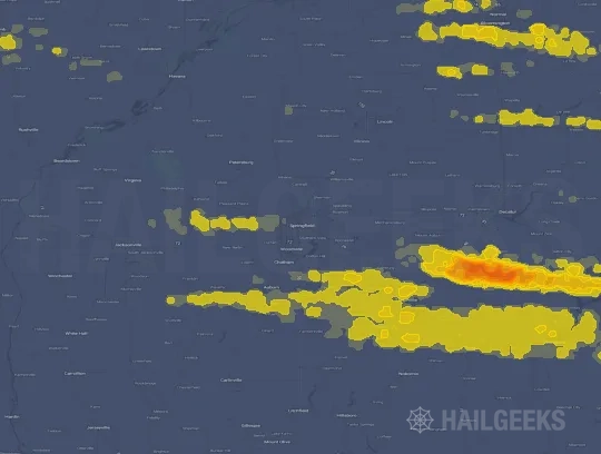
The Springfield, IL hail swath map preview was last reviewed on August 30, 2026 and shows mapped hail estimates up to 2.00". There are 17 public hail reports, 29 public wind reports, and 4 nearby tornado reports listed for the April 27, 2026 event.
View the April 27, 2026 Springfield, IL hail event on the free interactive hail map, then check a free Hail Report by ZIP to see a more local hail signal for your area.
Impact Area and Population for the Springfield, IL Hail Map
The April 27, 2026 hail swath map for Springfield, IL covers approximately 4,537 square miles and includes an estimated 242,852 people inside the mapped footprint. The largest mapped area is in the 0.50-0.75" hail band, covering 1,655 square miles. The highest estimated population exposure is in the 0.50-0.75" hail band with 77,313 people.
| Mapped Hail Band | Impact Area | Population |
|---|---|---|
| < 0.50" | 1,214 sq mi | 51,458 |
| 0.50-0.75" | 1,655 sq mi | 77,313 |
| 0.75-1.00" | 854 sq mi | 49,884 |
| 1.00-1.25" | 491 sq mi | 34,471 |
| 1.25-1.50" | 224 sq mi | 26,521 |
| 1.50-1.75" | 80 sq mi | 698 |
| 1.75-2.00" | 10 sq mi | 116 |
| 2.00-2.25" | 9 sq mi | 2,391 |
Get a free Hail Report by ZIP to see a more local hail signal and whether the April 27, 2026 Springfield, IL hail event may have reached your area.
Housing Exposure Inside the Springfield, IL Hail Swath Map
Inside the April 27, 2026 hail swath map area for Springfield, IL, HailGeeks estimates 121,598 single-family homes, 5,515 townhomes, and 22,142 multifamily properties within the mapped storm footprint. Single-family-home exposure is highest in the 0.50-0.75" hail band, with 36,967 single-family homes.
| Mapped Hail Band | Single-Family | Townhomes | Multifamily |
|---|---|---|---|
| < 0.50" | 23,670 | 1,726 | 4,015 |
| 0.50-0.75" | 36,967 | 1,580 | 4,137 |
| 0.75-1.00" | 24,579 | 1,354 | 4,281 |
| 1.00-1.25" | 19,797 | 536 | 4,081 |
| 1.25-1.50" | 14,505 | 316 | 5,408 |
| 1.50-1.75" | 406 | 2 | 18 |
| 1.75-2.00" | 70 | 0 | 3 |
| 2.00-2.25" | 1,604 | 1 | 199 |
Use this table to review housing exposure by hail band for the April 27, 2026 Springfield, IL hail map. To check a specific property more closely, use a free Hail Report by Address.
Counties Inside the Springfield, IL Hail Map
Hail from the April 27, 2026 storm was mapped across 26 counties in the Springfield, IL region. Macoupin County, IL had the strongest mapped signal, peaking at 2.00" with roughly 7,916 single-family homes inside the swath.
County pages group every mapped hail event in the area. For a closer look, drop to the city or ZIP level below, or run a free Hail Report by Address.
Cities Inside the Springfield, IL Hail Map
Zooming in, the swath touched 99 cities near Springfield, IL. Jerseyville, IL had the strongest mapped signal at 2.00", with an estimated 1,843 single-family homes exposed.
City cards show where the April 27, 2026 Springfield, IL hail activity was mapped, but your ZIP can show a closer local signal. Get a free Hail Report by ZIP, and if the signal looks meaningful, ask a local pro about a Remote Hail Inspection to see whether an on-site roof or exterior review may be worth scheduling.
ZIP Codes Inside the Springfield, IL Hail Swath Map
At the ZIP level, the April 27, 2026 Springfield, IL hail map spans 148 ZIP codes. ZIP 62052 shows the strongest local signal, with mapped hail estimates up to 2.00" and an estimated single-family-home exposure of 2,836.
Check your ZIP in seconds to see whether hail activity from the April 27, 2026 Springfield, IL event was mapped near your area.
Public Hail, Wind, and Tornado Reports
Public storm report tables connected to the April 27, 2026 hail map for Springfield, IL currently list 17 public hail reports, 29 public wind reports, and 4 tornado reports.
| Date & Time | Hail Size | City | State | Description |
|---|---|---|---|---|
April 27, 2026 8:50 AM CT |
1.25 in | Jerome | IL | delayed report from morning storms. Picture of quarter to half dollar size hail. |
April 27, 2026 8:55 AM CT |
1.00 in | 1 NE Southern View | IL | No National Weather Service description provided. |
April 27, 2026 8:56 AM CT |
1.00 in | 2 SE Springfield | IL | No National Weather Service description provided. |
April 27, 2026 8:56 AM CT |
1.00 in | 2 SE Southern View | IL | Report from mPING: Quarter (1.00 in.). |
April 27, 2026 8:57 AM CT |
1.50 in | Springfield | IL | No National Weather Service description provided. |
April 27, 2026 8:58 AM CT |
1.25 in | 1 SE Springfield | IL | Report from mPING: Half Dollar (1.25 in.). |
April 27, 2026 8:59 AM CT |
1.50 in | 1 SW Grandview | IL | No National Weather Service description provided. |
April 27, 2026 8:59 AM CT |
1.00 in | 1 W Jerome | IL | Report from mPING: Quarter (1.00 in.). |
April 27, 2026 9:01 AM CT |
1.00 in | Springfield | IL | Report from mPING: Quarter (1.00 in.). |
April 27, 2026 5:48 PM CT |
1.00 in | Pleasant Plains | IL | No National Weather Service description provided. |
April 27, 2026 5:52 PM CT |
1.00 in | Tallula | IL | North end of Tallula. |
April 27, 2026 5:55 PM CT |
1.50 in | Jerseyville | IL | No National Weather Service description provided. |
April 27, 2026 5:58 PM CT |
1.00 in | 1 N Jerseyville | IL | Report from mPING: Quarter (1.00 in.). |
April 27, 2026 6:00 PM CT |
2.50 in | Jerseyville | IL | No National Weather Service description provided. |
April 27, 2026 7:08 PM CT |
1.00 in | Bunker Hill | IL | Report from mPING: Quarter (1.00 in.). |
April 27, 2026 7:15 PM CT |
1.50 in | Litchfield | IL | No National Weather Service description provided. |
April 27, 2026 7:18 PM CT |
1.00 in | 2 S Benld | IL | Report from mPING: Quarter (1.00 in.). |
| Date & Time | Wind Speed | City | State | Description |
|---|---|---|---|---|
April 27, 2026 9:25 AM CT | 1 SW Chapin | IL | EMA reports tree and powerlines downed by thunderstorm winds. | |
April 27, 2026 10:38 AM CT | 1 NNE Farmersville | IL | Semi blown over onto the median. | |
April 27, 2026 10:48 AM CT | 2 SW Taylorville Airpor | IL | Tree downed across roadway... causing a semi rollover. | |
April 27, 2026 12:41 PM CT | Altamont | IL | Tree blown down into a mobile home. No injuries reported. | |
April 27, 2026 5:40 PM CT | 2 NE Alexander | IL | Power lines down. | |
April 27, 2026 6:05 PM CT | 2 NNW Waverly | IL | Large tree snapped... and wooden fence posts snapped at the base. Time estimated from radar. | |
April 27, 2026 6:14 PM CT | 1 WSW Lincoln | IL | Tree and power lines down. | |
April 27, 2026 6:16 PM CT | 1 WNW Mount Pulaski | IL | Large tree down & out building tin scattered around property. | |
April 27, 2026 6:16 PM CT | 3 SSE Nws Lincoln | IL | Large half of tree snapped along highway 121 north of Chestervale. | |
April 27, 2026 6:17 PM CT | 1 NNW Mount Pulaski | IL | Picture of tree snapped. | |
April 27, 2026 6:17 PM CT | 1 N Mount Pulaski | IL | Large tree uprooted. | |
April 27, 2026 6:20 PM CT | Medora | IL | Shed collapsed. | |
April 27, 2026 6:36 PM CT | 2 S Decatur | IL | 12 inch live tree with top blown off. | |
April 27, 2026 6:38 PM CT | 2 NNE Clinton | IL | Large tree branches broken. | |
April 27, 2026 6:42 PM CT | Lane | IL | Tree on a house. | |
April 27, 2026 6:43 PM CT | Lane | IL | Large branches down. | |
April 27, 2026 6:44 PM CT | 2 WNW De Land | IL | Corrects previous flash flood report from 2 WNW De Land. Deland-Weldon school sustained roof damage. | |
April 27, 2026 6:45 PM CT | 2 NW De Witt | IL | Power pole broken. | |
April 27, 2026 6:48 PM CT | Weldon | IL | Power poles down and possibly a home with roof off. | |
April 27, 2026 6:50 PM CT | 3 NE De Witt | IL | Tree trunk snapped near the base. | |
April 27, 2026 6:50 PM CT | 4 NNE De Witt | IL | 3 power poles broken along Leroy Rd. south of Buckeye Rd. | |
April 27, 2026 6:51 PM CT | 4 WSW Farmer City | IL | Large branches down in Parnell... with a broken power line southwest of town along the train tracks. | |
April 27, 2026 6:52 PM CT | 4 WSW Farmer City | IL | Tree trunks snapped. | |
April 27, 2026 6:54 PM CT | Mount Zion | IL | Tree fell on a building in Spitler Woods State Park. | |
April 27, 2026 9:36 AM CT | 60 mph | 1 N Marietta | IL | No National Weather Service description provided. |
April 27, 2026 6:15 PM CT | 60 mph | Nws Lincoln | IL | No National Weather Service description provided. |
April 27, 2026 6:38 PM CT | 70 mph | Warrensburg | IL | No National Weather Service description provided. |
April 27, 2026 6:39 PM CT | 80 mph | Latham | IL | Estimated 70-80 mph winds. |
April 27, 2026 6:43 PM CT | 80 mph | 3 W Warrensburg | IL | No National Weather Service description provided. |
| Date & Time | Rating | City | State | Description |
|---|---|---|---|---|
April 27, 2026 6:14 PM CT | UNK | 4 W Mount Pulaski | IL | EF1... max wind speed 90 mph... path length 15 miles... path width 400 yds. A tornado touched down in south central Logan County... commencing near the intersection of 1250th Ave and 600th St... where it caused minor tree damage. The tornado tracked east-northeast... impacting the northwest side of Mount Pulaski. Along this path... it crossed 700th St and State Route 121... resulting in further damage to trees... a machine shed... and several small grain silos. Continuing its movement... the tornado crossed State Highway 54... uprooting additional trees and tearing metal paneling from an old barn near the intersection of Highway 54 and 2000th Ave. The path continued just south of Chestnut... snapping small tree limbs... before crossing the Logan De Witt county line with minor tree damage. The tornado ultimately lifted approximately two miles south of Kenney. |
April 27, 2026 6:32 PM CT | UNK | Rowell | IL | EF1... max wind speed 88 mph... path length 6 miles... path width 400 yards. The tornado initially caused damage near the intersection of Rowell Rd and Bantam Rd... evidenced by extensive tree damage... including large trees snapped halfway up the trunk and a few healthy trees uprooted. Traveling east northeast along Rowell Rd... the storm continued to cause tree damage. It then crossed Rowell Rd near Bearsdale Rd... snapping a wooden power pole. Further damage was observed near the interchange of Rowell Rd and Highway 51... where a single residence home and a barn sustained minor roof damage. The tornado then turned northeast... causing minor roof damage to a home and additional minor tree damage along Ospur Rd before finally lifting just prior to reaching Weldon Springs Rd. |
April 27, 2026 6:41 PM CT | UNK | 3 SW Lane | IL | EF1... max wind 100 mph... path length 14 miles... path width 500 yards. The tornado developed 8 miles west of Weldon... snapping several electric poles and damaging trees. It continued tracking through the town of Weldon... causing more tree damage... removing roofing material from a single family residence... and peeling back the roof on the Deland-Weldon High School. The tornado crossed State Highway 10... striking a few farm outbuildings and damaging more trees before dissipating about 1 mile north of De Land. |
April 27, 2026 6:42 PM CT | UNK | 4 ESE Wapella | IL | Small machine shed collapsed with its debris strewn toward the ENE near the intersection of Birkbeck Rd and Northfork Rd. |
This table includes only public storm reports connected to the April 27, 2026 Springfield, IL storm event. When available, each report may include the time, size or magnitude, city, state, and a short description.
Related Hail Maps in the Springfield, IL Region
We found 6 more hail maps with reports from the same Springfield, IL region as the April 27, 2026 event. These related maps cover storm dates from Mar 22, 2026 through Apr 17, 2026, with mapped hail estimates ranging from 1.00" to 3.25". In this set, the strongest related map reached 3.25", and the most recent map shown is from Apr 17, 2026.



If none of these related Springfield, IL hail maps look close enough to your property, check a free Hail Report by Address. It reviews hail history for a specific location — not just the broader Springfield, IL region — so you can check whether hail activity may have reached your property.
Local Hail Review Options Near Springfield, IL
Not sure whether the April 27, 2026 Springfield, IL hail map matters for your property? Start with a free Hail Report by Address to see whether hail activity was mapped for that property. If the property signal looks meaningful, you can choose a local pro serving the Springfield, IL region and ask about a Remote Hail Inspection before deciding whether an on-site roof or exterior review is worth scheduling.
Check a specific property to see whether hail activity from the April 27, 2026 Springfield, IL event — or another recent hail event — may have been mapped at that address.
Find a roof or exterior pro serving the Springfield, IL region who can help you understand what the property hail signal may mean.
A participating local pro reviews property-level hail history remotely — not just the April 27, 2026 event — to help decide whether an on-site inspection may be worth scheduling.
A free Hail Report by Address and a Remote Hail Inspection can help you look beyond the April 27, 2026 hail map visuals alone. They do not confirm property damage and do not replace an on-site inspection for a property in the Springfield, IL region, but they can help you make a more informed next decision before anyone climbs on the roof.
Frequently Asked Questions
Common questions about the April 27, 2026 Springfield, IL hail event.