
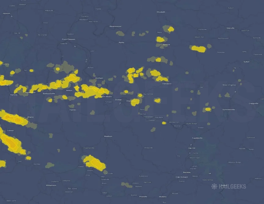
Hail Swath Map Preview
The Charleston, WV hail swath map preview was last reviewed on August 30, 2026 and shows mapped hail estimates up to 1.00". There are 0 public hail reports, 60 public wind reports, and 0 nearby tornado reports listed for the August 16, 2026 event.
View the August 16, 2026 Charleston, WV hail event on the free interactive hail map, then check a free Hail Report by ZIP to see a more local hail signal for your area.
Impact Area and Population for the Charleston, WV Hail Map
The August 16, 2026 hail swath map for Charleston, WV covers approximately 771 square miles and includes an estimated 84,403 people inside the mapped footprint. The largest mapped area is in the < 0.50" hail band, covering 423 square miles. The highest estimated population exposure is in the < 0.50" hail band with 38,336 people.
| Mapped Hail Band | Impact Area | Population |
|---|---|---|
| < 0.50" | 423 sq mi | 38,336 |
| 0.50-0.75" | 262 sq mi | 37,637 |
| 0.75-1.00" | 67 sq mi | 7,819 |
| 1.00-1.25" | 19 sq mi | 611 |
Get a free Hail Report by ZIP to see a more local hail signal and whether the August 16, 2026 Charleston, WV hail event may have reached your area.
Housing Exposure Inside the Charleston, WV Hail Swath Map
Inside the August 16, 2026 hail swath map area for Charleston, WV, HailGeeks estimates 39,903 single-family homes, 1,120 townhomes, and 12,223 multifamily properties within the mapped storm footprint. Single-family-home exposure is highest in the < 0.50" hail band, with 19,494 single-family homes.
| Mapped Hail Band | Single-Family | Townhomes | Multifamily |
|---|---|---|---|
| < 0.50" | 19,494 | 405 | 5,817 |
| 0.50-0.75" | 16,639 | 613 | 5,898 |
| 0.75-1.00" | 3,568 | 102 | 480 |
| 1.00-1.25" | 202 | 0 | 28 |
Use this table to review housing exposure by hail band for the August 16, 2026 Charleston, WV hail map. To check a specific property more closely, use a free Hail Report by Address.
Counties Inside the Charleston, WV Hail Map
Hail from the August 16, 2026 storm was mapped across 19 counties in the Charleston, WV region. Wayne County, WV had the strongest mapped signal, peaking at 1.00" with roughly 913 single-family homes inside the swath.
County pages group every mapped hail event in the area. For a closer look, drop to the city or ZIP level below, or run a free Hail Report by Address.
Cities Inside the Charleston, WV Hail Map
Zooming in, the swath touched 22 cities near Charleston, WV. Huntington, WV had the strongest mapped signal at 0.50", with an estimated 5,414 single-family homes exposed.
City cards show where the August 16, 2026 Charleston, WV hail activity was mapped, but your ZIP can show a closer local signal. Get a free Hail Report by ZIP, and if the signal looks meaningful, ask a local pro about a Remote Hail Inspection to see whether an on-site roof or exterior review may be worth scheduling.
ZIP Codes Inside the Charleston, WV Hail Swath Map
At the ZIP level, the August 16, 2026 Charleston, WV hail map spans 66 ZIP codes. ZIP 41230 shows the strongest local signal, with mapped hail estimates up to 1.00" and an estimated single-family-home exposure of 446.
Check your ZIP in seconds to see whether hail activity from the August 16, 2026 Charleston, WV event was mapped near your area.
Public Hail, Wind, and Tornado Reports
Public storm report tables connected to the August 16, 2026 hail map for Charleston, WV currently list 0 public hail reports, 60 public wind reports, and 0 tornado reports.
| Date & Time | Hail Size | City | State | Description |
|---|---|---|---|---|
| No public hail reports are available for this event. | ||||
| Date & Time | Wind Speed | City | State | Description |
|---|---|---|---|---|
August 16, 2026 12:51 PM CT | 4 Ene Ravenswood | WV | Tree damage resulting in approximately 120 customers without power. Time is estimated by radar. | |
August 16, 2026 1:02 PM CT | 6 E Point Pleasant | WV | 5 trees down with lines involved in the 600 block of Rayburn Rd. | |
August 16, 2026 1:14 PM CT | 3 Wnw Reedy | WV | Over 800 customers without power due to tree damage. | |
August 16, 2026 1:40 PM CT | 4 Sw Grantsville | WV | Tree in Roadway in the 6000 block of Pine Creek Road). Time estimated from radar. | |
August 16, 2026 1:52 PM CT | 11 Sse Spencer | WV | Tree in Roadway on the 300 block of Poca Road. Time estimated from radar. | |
August 16, 2026 1:52 PM CT | 7 Ssw Cedar Creek State | WV | Tree down in the 500 block of Briery Lick Rd. Time estimated from radar. | |
August 16, 2026 1:54 PM CT | 9 Ese Arnoldsburg | WV | Tree down in the 900 block of Laurel Run Road in Rosedale. Time estimated from radar. | |
August 16, 2026 1:59 PM CT | 4 Sw Cedar Creek State | WV | Tree down in 1400 block of Gassaway Road in Normantown. Time estimated from radar. | |
August 16, 2026 2:08 PM CT | 5 Nw Gassaway | WV | Tree down along 2300 block of Skidmore School Road. Time estimated from radar. | |
August 16, 2026 2:12 PM CT | 3 W Burnsville | WV | Multiple trees down_ wires down in the 7000 block of Copen Rd. Time estimated from radar. | |
August 16, 2026 2:12 PM CT | 7 N Gassaway | WV | Multiple trees down blocking all lanes in the 3000 block of Trace Run Rd. Time estimated from radar. | |
August 16, 2026 2:18 PM CT | 3 Nne Flatwoods | WV | Tree down in the 100 block of Berry Fork Rd. Time estimated from radar. | |
August 16, 2026 2:32 PM CT | 3 W Milton | WV | Tree in Roadway on US-60 and Yates Crossing Rd. Time estimated from radar. | |
August 16, 2026 2:42 PM CT | 1 Sw Institute | WV | Tree on Power Lines in the 100 block of Hampshire Dr. Time estimated from radar. | |
August 16, 2026 3:14 PM CT | 2 Sse South Charleston | WV | Corrects previous flash flood report from 2 SSE South Charleston. Tree down Berry Hills and Double Eagle Dr. Time estimated from radar. | |
August 16, 2026 3:14 PM CT | 4 Sw Charleston | WV | Tree down Kanawha State Forest Dr and Kessenger Rd. Time estimated from radar. | |
August 16, 2026 3:52 PM CT | Ansted | WV | Roof partially ripped off neighbors home. | |
August 16, 2026 4:01 PM CT | 5 Ne Ansted | WV | Tree on power line. | |
August 16, 2026 4:06 PM CT | 2 Ese Ansted | WV | Tree in Roadway on US 60. Time estimated from radar. | |
August 16, 2026 4:16 PM CT | 10 Ssw Summersville | WV | Tree damage resulting in approximately 1500 customers without power. | |
August 16, 2026 4:50 PM CT | 3 Wsw Meadow Bluff | WV | Tree fell across Holliday Run Road_ blocking the entire road near the intersection of Callahan School Road near Alderson_ WV. Time is estimated from radar. | |
August 16, 2026 4:55 PM CT | 1 Ne Asbury | WV | Tree has fallen and blocked Alta Drive near the intersection of Old Asbury Road near Asbury_ WV. Time is estimated from radar. | |
August 16, 2026 4:55 PM CT | 2 Ssw Asbury | WV | Tree down near the intersection of Alta Drive and Dyer Lane near Alderson_ WV. Time is estimated from radar. | |
August 16, 2026 5:48 PM CT | 2 Ene Ironton | OH | Tree and lines down. The transformer exploded and the tree was on fire. Time estimated from radar. | |
August 16, 2026 5:53 PM CT | 2 Sse Wayne | WV | Tree down blocking Two Mile Creek Road. | |
August 16, 2026 6:03 PM CT | 2 S Crown City | OH | Tree down blocking the roadway at County Road 9 and State Route 7. Time estimated from radar. | |
August 16, 2026 6:18 PM CT | 7 Nnw Hurricane | WV | Tree down blocking Five and Twenty Mile Creek Road. | |
August 16, 2026 6:24 PM CT | 4 Wsw Eleanor | WV | Tree down blocking roadway at Hurricane Creek Road and Bear Paw Lane. | |
August 16, 2026 6:29 PM CT | 7 Nne Milton | WV | Tree down across Whitten Ridge completely blocking the road. Time estimated from radar. | |
August 16, 2026 6:30 PM CT | 3 S Buffalo | WV | Tree down blocking left lane of traffic on Lock 9 Road at Charleston Road. Time estimated from radar. | |
August 16, 2026 6:30 PM CT | 4 Ssw Buffalo | WV | Tree down in 2200 block of Staves Branch Road_ Fraziers Bottom. Time estimated from radar. | |
August 16, 2026 6:30 PM CT | 7 Sw Buffalo | WV | Tree down blocking Jolly Road Milton. Time estimated from radar. | |
August 16, 2026 6:34 PM CT | 1 Nne Winfield | WV | Tree down blocking one lane of traffic in 11200 block of Winfield Road near the Winfield High School. | |
August 16, 2026 6:36 PM CT | 2 Sse Eleanor | WV | Tree down blocking State Route 34 in the 4200 block. Time estimated from radar. | |
August 16, 2026 6:36 PM CT | 3 Nne Winfield | WV | Multiple trees down along McClane Pike about two miles out from Route 62_ just past Wilkie Road. Time estimated from radar. | |
August 16, 2026 6:37 PM CT | 3 S Winfield | WV | Tree and lines came down in the 2700 block of Rocky Step Road in Scott Depot and hit two cars. Time estimated from radar. | |
August 16, 2026 6:44 PM CT | 13 S Louisa | KY | Tree damage resulting in approximately 750 customers without power. | |
August 16, 2026 6:48 PM CT | 1 Sw South Charleston | WV | Tree down at Hannon Lane and Chestnut Street in Jefferson. Time estimated from radar. | |
August 16, 2026 7:00 PM CT | 1 N Add | KY | Reports of trees down and blocking the roadways at this location. People cannot get in or out of the area. | |
August 16, 2026 7:00 PM CT | 2 W Meta | KY | Few trees down along Mikes Branch. Time estimated by radar. | |
August 16, 2026 7:00 PM CT | Inez | KY | Social media report of wind knocking gas pump over at the Marathon in Inez. Time estimated via radar. | |
August 16, 2026 7:02 PM CT | 2 N Job | KY | Social media report that there are powerlines on old rt 3 on the Martin/Lawrence County line. Time estimated via radar. | |
August 16, 2026 7:02 PM CT | 1 Ese Charleston | WV | Corrects previous non-tstm to tstm wnd dmg report from 1 ESE Charleston. Tree down along Greenbrier Street at Hillcrest Drive. Time estimated from radar. | |
August 16, 2026 7:05 PM CT | 1 Nw Calf Creek | KY | Social media report of lots of trees down and debris in the Fluty Lick area. | |
August 16, 2026 7:05 PM CT | 1 Ssw Calf Creek | KY | Social media reports of lots of trees and debris in the Calf Creek area. Time estimated via radar. | |
August 16, 2026 7:05 PM CT | Beauty | KY | Local FD advises motorists to use caution because there is a tree down on KY-40 near the Beauty post office. Time estimated via radar. | |
August 16, 2026 7:06 PM CT | 10 Sse Louisa | KY | Tree damage resulting in approximately 50 customers without power. | |
August 16, 2026 7:07 PM CT | Beauty | KY | Social media reports of tree damage in the road near Rons Pawn Shop in Beauty_ KY. Time estimated via radar. | |
August 16, 2026 7:09 PM CT | Inez | KY | Public report on social media showing a tree down on a carport somewhere in Inez/Martin County. | |
August 16, 2026 7:10 PM CT | 1 N Warfield | KY | Social media report of tree debris in the roadway in the Warfield_ KY area. Time estimated via radar. | |
August 16, 2026 7:13 PM CT | Tomahawk | KY | Social media report of tree branches and debris down at their location somewhere in Tomahawk. Times estimated via radar. | |
August 16, 2026 7:18 PM CT | 6 Wsw Clay | WV | Tree damage resulting in approximately 250 customers without power. Time is estimated by radar. | |
August 16, 2026 7:20 PM CT | 8 Ese Pinch | WV | Tree damage resulting in approximately 250 customers without power. Time is estimated by radar. | |
August 16, 2026 7:38 PM CT | 4 Nw Birch River | WV | Tree on power line. | |
August 16, 2026 7:39 PM CT | 1 Se Ansted | WV | Tree on power line. | |
August 16, 2026 7:49 PM CT | 2 Wnw Summersville | WV | Tree damage resulting in approximately 40 customers without power. Time is estimated by radar. | |
August 16, 2026 7:58 PM CT | 9 Ssw Summersville | WV | Tree damage resulting in approximately 110 customers without power. Time is estimated by radar. | |
August 16, 2026 8:00 PM CT | 2 W Meta | KY | Corrects time of previous tstm wnd dmg report. Few trees down along Mikes Branch. Time estimated by radar. | |
August 16, 2026 8:20 PM CT | 1 Sw Duo | WV | Several large trees down with lines near the railroad crossing on Anjean Road close to Duo Road in Rupert_ WV. Time is estimated from radar. | |
August 16, 2026 8:20 PM CT | 2 Sw Quinwood | WV | Tree down on power lines across Bellburn Road_ near Charmco_ WV. Time is estimated from radar. |
| Date & Time | Rating | City | State | Description |
|---|---|---|---|---|
| No public tornado reports are available for this event. | ||||
This table includes only public storm reports connected to the August 16, 2026 Charleston, WV storm event. When available, each report may include the time, size or magnitude, city, state, and a short description.
Related Hail Maps in the Charleston, WV Region
We found 6 more hail maps with reports from the same Charleston, WV region as the August 16, 2026 event. These related maps cover storm dates from Aug 5, 2026 through Aug 11, 2026, with mapped hail estimates ranging from 0.75" to 2.00". In this set, the strongest related map reached 2.00", and the most recent map shown is from Aug 11, 2026.


If none of these related Charleston, WV hail maps look close enough to your property, check a free Hail Report by Address. It reviews hail history for a specific location — not just the broader Charleston, WV region — so you can check whether hail activity may have reached your property.
Local Hail Review Options Near Charleston, WV
Not sure whether the August 16, 2026 Charleston, WV hail map matters for your property? Start with a free Hail Report by Address to see whether hail activity was mapped for that property. If the property signal looks meaningful, you can choose a local pro serving the Charleston, WV region and ask about a Remote Hail Inspection before deciding whether an on-site roof or exterior review is worth scheduling.
Check a specific property to see whether hail activity from the August 16, 2026 Charleston, WV event — or another recent hail event — may have been mapped at that address.
Find a roof or exterior pro serving the Charleston, WV region who can help you understand what the property hail signal may mean.
A participating local pro reviews property-level hail history remotely — not just the August 16, 2026 event — to help decide whether an on-site inspection may be worth scheduling.
A free Hail Report by Address and a Remote Hail Inspection can help you look beyond the August 16, 2026 hail map visuals alone. They do not confirm property damage and do not replace an on-site inspection for a property in the Charleston, WV region, but they can help you make a more informed next decision before anyone climbs on the roof.
Frequently Asked Questions
Common questions about the August 16, 2026 Charleston, WV hail event.