

Hail Swath Map Preview
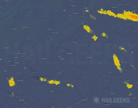
The Lynchburg, VA hail swath map preview was last reviewed on August 30, 2026 and shows mapped hail estimates up to 1.00". There are 0 public hail reports, 23 public wind reports, and 0 nearby tornado reports listed for the August 16, 2026 event.
View the August 16, 2026 Lynchburg, VA hail event on the free interactive hail map, then check a free Hail Report by ZIP to see a more local hail signal for your area.
Impact Area and Population for the Lynchburg, VA Hail Map
The August 16, 2026 hail swath map for Lynchburg, VA covers approximately 272 square miles and includes an estimated 16,001 people inside the mapped footprint. The largest mapped area is in the 0.50-0.75" hail band, covering 124 square miles. The highest estimated population exposure is in the 0.50-0.75" hail band with 7,652 people.
| Mapped Hail Band | Impact Area | Population |
|---|---|---|
| < 0.50" | 107 sq mi | 5,675 |
| 0.50-0.75" | 124 sq mi | 7,652 |
| 0.75-1.00" | 33 sq mi | 2,479 |
| 1.00-1.25" | 9 sq mi | 195 |
Get a free Hail Report by ZIP to see a more local hail signal and whether the August 16, 2026 Lynchburg, VA hail event may have reached your area.
Housing Exposure Inside the Lynchburg, VA Hail Swath Map
Inside the August 16, 2026 hail swath map area for Lynchburg, VA, HailGeeks estimates 7,699 single-family homes, 396 townhomes, and 507 multifamily properties within the mapped storm footprint. Single-family-home exposure is highest in the 0.50-0.75" hail band, with 3,694 single-family homes.
| Mapped Hail Band | Single-Family | Townhomes | Multifamily |
|---|---|---|---|
| < 0.50" | 2,734 | 44 | 114 |
| 0.50-0.75" | 3,694 | 211 | 329 |
| 0.75-1.00" | 1,149 | 137 | 64 |
| 1.00-1.25" | 122 | 4 | 0 |
Use this table to review housing exposure by hail band for the August 16, 2026 Lynchburg, VA hail map. To check a specific property more closely, use a free Hail Report by Address.
Counties Inside the Lynchburg, VA Hail Map
Hail from the August 16, 2026 storm was mapped across 14 counties in the Lynchburg, VA region. Albemarle County, VA had the strongest mapped signal, peaking at 1.00" with roughly 4,115 single-family homes inside the swath.
County pages group every mapped hail event in the area. For a closer look, drop to the city or ZIP level below, or run a free Hail Report by Address.
Cities Inside the Lynchburg, VA Hail Map
Zooming in, the swath touched 6 cities near Lynchburg, VA. Crozet, VA had the strongest mapped signal at 0.50", with an estimated 1,242 single-family homes exposed.
City cards show where the August 16, 2026 Lynchburg, VA hail activity was mapped, but your ZIP can show a closer local signal. Get a free Hail Report by ZIP, and if the signal looks meaningful, ask a local pro about a Remote Hail Inspection to see whether an on-site roof or exterior review may be worth scheduling.
ZIP Codes Inside the Lynchburg, VA Hail Swath Map
At the ZIP level, the August 16, 2026 Lynchburg, VA hail map spans 18 ZIP codes. ZIP 22903 shows the strongest local signal, with mapped hail estimates up to 1.00" and an estimated single-family-home exposure of 2,223.
Check your ZIP in seconds to see whether hail activity from the August 16, 2026 Lynchburg, VA event was mapped near your area.
Public Hail, Wind, and Tornado Reports
Public storm report tables connected to the August 16, 2026 hail map for Lynchburg, VA currently list 0 public hail reports, 23 public wind reports, and 0 tornado reports.
| Date & Time | Hail Size | City | State | Description |
|---|---|---|---|---|
| No public hail reports are available for this event. | ||||
| Date & Time | Wind Speed | City | State | Description |
|---|---|---|---|---|
August 16, 2026 7:05 AM CT | 2 Sse Evington | VA | Tree down on Dearborn Road. | |
August 16, 2026 5:00 PM CT | 4 N Stuarts Draft | VA | Tree down on Ramsey Road. | |
August 16, 2026 5:00 PM CT | 4 Se Staunton | VA | Tree down on I-64 westbound. | |
August 16, 2026 5:08 PM CT | 1 N Greenfield | VA | Tree down 8000 block of Rockfish Valley Highway. | |
August 16, 2026 5:21 PM CT | Greenwood | VA | Tree down along 7500 block of Rockfish Gap Turnpike | |
August 16, 2026 5:23 PM CT | 1 N Greenfield | VA | Tree down 8000 block of Rockfish Valley Highway. | |
August 16, 2026 5:23 PM CT | 2 Sse Greenwood | VA | Tree down 7500 block of Rockfish Gap Turnpike. | |
August 16, 2026 5:26 PM CT | 53 mph | 3 S Hollins | VA | Reported by Trained Spotter. |
August 16, 2026 5:31 PM CT | Earlysville | VA | Numerous reports of trees down in northern Albemarle County. | |
August 16, 2026 5:35 PM CT | Earlysville | VA | Tree down along Earlysville Rd and Clan Chisholm Ln | |
August 16, 2026 5:45 PM CT | 4 Wsw Overton | VA | Tree down near intersection of Scottsville Rd and Fairwood Ln | |
August 16, 2026 5:45 PM CT | Charlottesville | VA | Multiple trees down in the Charlottesville area | |
August 16, 2026 5:50 PM CT | Scottsville | VA | Few trees down in the Scottsville area | |
August 16, 2026 5:54 PM CT | Keswick | VA | Few trees down in the Keswick area | |
August 16, 2026 5:54 PM CT | Woodridge | VA | Numerous reports of trees down in southern Albemarle County. | |
August 16, 2026 5:58 PM CT | 7 Ese Elma | VA | Tree down near intersection of Howardsville Turnpike and Cabell Road. | |
August 16, 2026 6:05 PM CT | 1 Wnw Troy | VA | Trees down on Oliver Creek Road. | |
August 16, 2026 6:06 PM CT | 4 Sw Antioch | VA | Tree down on Antioch Road. | |
August 16, 2026 6:09 PM CT | 1 Nne Zion Crossroads | VA | Report of numerous trees down in the Zion Crossroads area. | |
August 16, 2026 6:45 PM CT | 1 S Centenary | VA | Multiple trees reported down in Buckingham County. | |
August 16, 2026 7:10 PM CT | 2 Sse Evington | VA | Corrects previous tstm wnd dmg report from 2 SSE Evington. Tree down on Dearborn Road. | |
August 16, 2026 7:15 PM CT | 4 Wsw Rustburg | VA | Tree down in the 900 block of Greenhouse Road. | |
August 16, 2026 7:20 PM CT | 2 Nw Hodges | VA | Tree has fallen across Gladys Road_ blocking both lanes near the intersection of Levonne Street_ in Altavista_ VA. Time is estimated from radar. |
| Date & Time | Rating | City | State | Description |
|---|---|---|---|---|
| No public tornado reports are available for this event. | ||||
This table includes only public storm reports connected to the August 16, 2026 Lynchburg, VA storm event. When available, each report may include the time, size or magnitude, city, state, and a short description.
Related Hail Maps in the Lynchburg, VA Region
We found 6 more hail maps with reports from the same Lynchburg, VA region as the August 16, 2026 event. These related maps cover storm dates from Jul 26, 2026 through Aug 14, 2026, with mapped hail estimates ranging from 0.75" to 3.25". In this set, the strongest related map reached 3.25", and the most recent map shown is from Aug 14, 2026.


If none of these related Lynchburg, VA hail maps look close enough to your property, check a free Hail Report by Address. It reviews hail history for a specific location — not just the broader Lynchburg, VA region — so you can check whether hail activity may have reached your property.
Local Hail Review Options Near Lynchburg, VA
Not sure whether the August 16, 2026 Lynchburg, VA hail map matters for your property? Start with a free Hail Report by Address to see whether hail activity was mapped for that property. If the property signal looks meaningful, you can choose a local pro serving the Lynchburg, VA region and ask about a Remote Hail Inspection before deciding whether an on-site roof or exterior review is worth scheduling.
Check a specific property to see whether hail activity from the August 16, 2026 Lynchburg, VA event — or another recent hail event — may have been mapped at that address.
Find a roof or exterior pro serving the Lynchburg, VA region who can help you understand what the property hail signal may mean.
A participating local pro reviews property-level hail history remotely — not just the August 16, 2026 event — to help decide whether an on-site inspection may be worth scheduling.
A free Hail Report by Address and a Remote Hail Inspection can help you look beyond the August 16, 2026 hail map visuals alone. They do not confirm property damage and do not replace an on-site inspection for a property in the Lynchburg, VA region, but they can help you make a more informed next decision before anyone climbs on the roof.
Frequently Asked Questions
Common questions about the August 16, 2026 Lynchburg, VA hail event.