Heads up! Small hail spotted in these regions: Morgantown, WV • Lubbock, TXATTENTION! Damaging hail detected. Hail tracking is now active for these regions: Midland, TX • Columbus, OH • Wheeling, WV • Weirton, WV
HailGeeks
Free Interactive Hail Map

Hail Map with Reports for Beckley, WV

View the free hail map with reports for Beckley, WV from September 21, 2026. This event is marked as Complete, with a Moderate storm impact level and a Moderate Event Inspection Score.

Free Interactive Hail Map Hail Report by ZIP
Moderate
Event Inspection Score
Moderate
Storm Impact
Complete
Event Status
Sep 21, 2026
Event Date
Map Preview

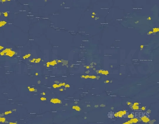
Hail Swath Map Preview

The Beckley, WV hail swath map preview was last reviewed on September 24, 2026 and shows mapped hail estimates up to 1.50". There are 1 public hail reports, 15 public wind reports, and 0 nearby tornado reports listed for the September 21, 2026 event.

Region: Beckley, WV
September 21, 2026 Hail swath map preview for Beckley, WV on September 21, 2026
Open Interactive Map
Max Hail
1.50"
Mapped estimated hail size
Public Hail Reports
1
Largest report: 1.00"
Public Wind Reports
15
Reports near map area
Tornado Reports
0
Reports near map area

View the September 21, 2026 Beckley, WV hail event on the free interactive hail map, then check a free Hail Report by ZIP to see a more local hail signal for your area.

Map Footprint

Impact Area and Population for the Beckley, WV Hail Map

The September 21, 2026 hail swath map for Beckley, WV covers approximately 770 square miles and includes an estimated 33,763 people inside the mapped footprint. The largest mapped area is in the < 0.50" hail band, covering 376 square miles. The highest estimated population exposure is in the < 0.50" hail band with 19,318 people.

Mapped Impact Area
770 sq mi
Largest band: < 0.50"
Population Inside Footprint
33,763
Highest population band: < 0.50"
Mapped Hail BandImpact AreaPopulation
< 0.50"376 sq mi19,318
0.50-0.75"271 sq mi10,818
0.75-1.00"92 sq mi2,994
1.00-1.25"23 sq mi470
1.25-1.50"6 sq mi139
1.50-1.75"2 sq mi24

Get a free Hail Report by ZIP to see a more local hail signal and whether the September 21, 2026 Beckley, WV hail event may have reached your area.

Housing Impact

Housing Exposure Inside the Beckley, WV Hail Swath Map

Inside the September 21, 2026 hail swath map area for Beckley, WV, HailGeeks estimates 17,753 single-family homes, 219 townhomes, and 2,008 multifamily properties within the mapped storm footprint. Single-family-home exposure is highest in the < 0.50" hail band, with 9,357 single-family homes.

Single-Family Homes
17,753
Largest band: < 0.50"
Townhomes
219
Largest band: < 0.50"
Multifamily Properties
2,008
Largest band: < 0.50"
Mapped Hail BandSingle-FamilyTownhomesMultifamily
< 0.50"9,3571481,525
0.50-0.75"6,36059374
0.75-1.00"1,6531195
1.00-1.25"298114
1.25-1.50"6900
1.50-1.75"1600

Use this table to review housing exposure by hail band for the September 21, 2026 Beckley, WV hail map. To check a specific property more closely, use a free Hail Report by Address.

ZIP Codes

ZIP Codes Inside the Beckley, WV Hail Swath Map

At the ZIP level, the September 21, 2026 Beckley, WV hail map spans 80 ZIP codes. ZIP 25969 shows the strongest local signal, with mapped hail estimates up to 1.50" and an estimated single-family-home exposure of 431.

25969WV
431 homes in the hail path
25951Hinton, WV
339 homes in the hail path
24739Oakvale, WV
2K homes in the hail path
24740Princeton, WV
296 homes in the hail path
25979WV
228 homes in the hail path
25922WV
20 homes in the hail path
24614Grundy, VA
670 homes in the hail path
25508Chapmanville, WV
249 homes in the hail path
25841WV
188 homes in the hail path
25978WV
146 homes in the hail path
25820WV
117 homes in the hail path
24963Peterstown, WV
104 homes in the hail path
Showing 12 of 80 ZIP codes

Check your ZIP in seconds to see whether hail activity from the September 21, 2026 Beckley, WV event was mapped near your area.

Public Storm Reports

Public Hail, Wind, and Tornado Reports

Public storm report tables connected to the September 21, 2026 hail map for Beckley, WV currently list 1 public hail reports, 15 public wind reports, and 0 tornado reports.

Date & TimeHail SizeCityStateDescription
September 21, 2026
4:39 PM CT
1.00 in 1 Nne Pipestem WV

Hail 1 inch in diameter is observed on True Road in Pipestem.

Showing 1 public hail reports

This table includes only public storm reports connected to the September 21, 2026 Beckley, WV storm event. When available, each report may include the time, size or magnitude, city, state, and a short description.

Related Hail Maps

Related Hail Maps in the Beckley, WV Region

We found 6 more hail maps with reports from the same Beckley, WV region as the September 21, 2026 event. These related maps cover storm dates from Aug 16, 2026 through Sep 17, 2026, with mapped hail estimates ranging from 0.75" to 1.25". In this set, the strongest related map reached 1.25", and the most recent map shown is from Sep 17, 2026.

If none of these related Beckley, WV hail maps look close enough to your property, check a free Hail Report by Address. It reviews hail history for a specific location — not just the broader Beckley, WV region — so you can check whether hail activity may have reached your property.

Remote Hail Inspection

Local Hail Review Options Near Beckley, WV

Not sure whether the September 21, 2026 Beckley, WV hail map matters for your property? Start with a free Hail Report by Address to see whether hail activity was mapped for that property. If the property signal looks meaningful, you can choose a local pro serving the Beckley, WV region and ask about a Remote Hail Inspection before deciding whether an on-site roof or exterior review is worth scheduling.

Get a Free Hail Report by Address

Check a specific property to see whether hail activity from the September 21, 2026 Beckley, WV event — or another recent hail event — may have been mapped at that address.

A Participating Local Pro

Find a roof or exterior pro serving the Beckley, WV region who can help you understand what the property hail signal may mean.

Remote Hail Inspection

A participating local pro reviews property-level hail history remotely — not just the September 21, 2026 event — to help decide whether an on-site inspection may be worth scheduling.

A free Hail Report by Address and a Remote Hail Inspection can help you look beyond the September 21, 2026 hail map visuals alone. They do not confirm property damage and do not replace an on-site inspection for a property in the Beckley, WV region, but they can help you make a more informed next decision before anyone climbs on the roof.

FAQ

Frequently Asked Questions

Common questions about the September 21, 2026 Beckley, WV hail event.

How big was the hail in Beckley, WV on September 21, 2026?
Mapped hail estimates reached up to 1.50" in the Beckley, WV area on September 21, 2026.
How accurate is this Beckley, WV hail map?
This hail map is based on mapped hail estimates, with public storm report context shown where available. It helps show where stronger hail may have occurred during the September 21, 2026 storm event, but it does not confirm property damage at any one address.
What does the Event Inspection Score of Moderate mean?
For this Beckley, WV event, the Event Inspection Score is Moderate. The score reflects how strong the hail-history signal is and whether a closer roof or exterior review may make sense. A higher score means a stronger signal, not confirmed damage.
How many people were in the Beckley, WV hail area?
An estimated 33,763 people live inside the mapped hail footprint, which covers about 770 square miles. This is an estimate of residents inside the storm area, not a count of people who reported damage.
How many storm reports came from this event?
For the September 21, 2026 Beckley, WV event, public storm report tables currently list 1 hail reports, 15 wind reports, and 0 tornado reports. Public reports are point observations and are not available for every location.
Can I use this Beckley, WV hail map for my business or content?
Yes. This hail map is free to use and share for marketing, print, blogs, content, research, and similar uses as long as attribution is included with a link back to this page. Use the Share button on the map to copy a ready-made credit line. Use is also subject to our Terms of Use.
How often is this hail map updated?
This event map was generated shortly after the storm and was last reviewed on September 24, 2026. It may be updated as additional hail data or public storm reports become available.
My home is in the Beckley, WV area — what should I do?
If your address falls inside a mapped hail band from the September 21, 2026 storm event, check a free Hail Report by Address for an address-level first look. You can also ask a qualified local pro whether a closer roof or exterior review may make sense.
Free Hail Report By Address

Check Your Address in Seconds

Free hail report for any address in the contiguous U.S.

Get a Free Hail Report

100% free. No phone or email required.