Heads up! Small hail spotted in these regions: Morgantown, WV • Lubbock, TXATTENTION! Damaging hail detected. Hail tracking is now active for these regions: Midland, TX • Columbus, OH • Wheeling, WV • Weirton, WV
Hi folks! Stay ahead of the storm with a 48-hour severe weather outlook, precise hail alerts, and live hail tracking. Access hail insights, historical hail maps, and detailed reports across 300+ regions for better planning and fewer "uh-oh" moments. Stay informed, stay safe, and stay protected - all completely free.
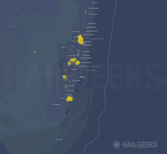
View the free hail map with reports for Miami, FL from September 29, 2026. This event is marked as Complete, with a Light storm impact level and a Low Event Inspection Score.
The Miami, FL hail swath map preview was last reviewed on October 2, 2026 and shows mapped hail estimates up to 0.75". There are 0 public hail reports, 0 public wind reports, and 0 nearby tornado reports listed for the September 29, 2026 event.
Region: Miami, FL
Share this hail event
Publish a local update, prepare a story or share the facts. Choose what you need.
Publish & report
Quick share
HAILGEEKS · QUICK MEDIA BRIEF · EVENT 125480
Miami, FL
September 29, 2026 Processing status: Complete
Data last updated October 2, 2026, 2:01 a.m. CDT. Recheck the source before publishing; figures may change.
Includes key facts, suggested wording, a map caption, source links and credit. Plain text for your editor, email or rundown.
Key facts
0.75″Largest radar-estimated hail · inchesRadar estimate, not a ground measurement
0Single-family homes in hail areaEstimated exposure, not damaged homes
0Estimated residents in hail areaEstimated residents within the footprint
134Hail area · square milesExtent of the radar-derived footprint
HailGeeks’ map for Miami, FL, on September 29, 2026 shows radar-derived hail estimates up to 0.75 inches. The mapped hail area covers approximately 134 square miles and includes an estimated 0 single-family homes. These figures describe potential exposure to hail, not confirmed property damage.
For radio & podcasts
Suggested on-air wording. Adapt to your voice and verify against the latest event data.
According to HailGeeks, radar data indicates hail may have fallen near Miami, FL, on September 29, 2026. The largest mapped hail estimate was 0.75 inches. The map shows potential hail exposure. It does not confirm damage to homes or other property.
Credit HailGeeks on air; add the event link to your show notes or accompanying story.
Before you publish
Public storm reports are observations at specific locations and may be preliminary. They are separate from radar estimates. No listed reports does not mean no hail occurred. Event status describes processing, not a weather warning or an all-clear.
Credit & map caption
Source: HailGeeks, using NOAA NEXRAD radar data and NWS/SPC public storm reports. https://www.hailgeeks.com/maps/125480/miami-fl/September-29-2026/
Radar-derived hail estimates near Miami, FL, for September 29, 2026. The mapped area shows potential exposure, not confirmed property damage. Map: HailGeeks.
Keep the event date, legend and source visible. Free to use with attribution, subject to the Terms of Use.
HAILGEEKS · COMPLETE EVENT REPORT · ID 125480
Miami, FL
September 29, 2026 Processing status: Complete
Data last updated October 2, 2026, 2:01 a.m. CDT
All available local statistics and public observations. Figures reflect the update above and may change.
Download HTML for a standalone page. Use One-click blog post to paste into WordPress or another editor’s Custom HTML block: styling is limited to the report, with your page’s background, text color and font. Keep the source credit; exports are snapshots.
Preview standalone HTML
This is the standalone download, with its own white background. Source links open in a new tab.
Radar estimates describe potential exposure, not confirmed damage. Public observations may be preliminary. Inspection Scores are HailGeeks indicators, not damage assessments. A dash (—) means unavailable; 0 means zero.
HailGeeks’ map for Miami, FL, on September 29, 2026 shows radar-derived hail estimates up to 0.75 inches. The mapped hail area covers approximately 134 square miles and includes an estimated 0 single-family homes. These figures describe potential exposure to hail, not confirmed property damage.
Suggested wording for your coverage. Use the figures below for local detail.
Radar-derived hail estimates · September 29, 2026 · Map: HailGeeks. The mapped area shows potential exposure, not confirmed damage.
Key figures for this event
The footprint is the area where radar indicates hail may have fallen. Each figure below describes that area.
0.75″Largest radar-estimated hail · inchesRadar estimate, not a ground measurement
0Single-family homes in hail areaEstimated exposure, not damaged homes
0Estimated residents in hail areaEstimated residents within the footprint
134Hail area · square milesExtent of the radar-derived footprint
Storm impact LightEvent Inspection Score Low
Local breakdown: counties, cities and ZIP codes
Use these tables to identify the communities in the mapped hail area. Home counts cover the portion of each location inside that area, not all homes in the county, city or ZIP code.
Counties
No counties statistics are available for this event.
Cities
No cities statistics are available for this event.
ZIP codes
No zip codes statistics are available for this event.
Housing exposure by estimated hail size
Each row groups properties by the estimated hail diameter at their mapped location. For example, 0.50–0.75″ denotes a hail-size band in inches. Multifamily counts represent properties, not individual dwelling units.
Hail size
Single-family
Townhomes
Multifamily
No hail-size breakdown is available.
Event total
0
0
0
Hail area and population by estimated hail size
Each row shows the area and estimated resident population within a hail-size band. Rounded area rows may differ slightly from the event total.
Hail size
Area · sq mi
Population
< 0.50"
96
0
0.50-0.75"
30
0
0.75-1.00"
8
0
Event total
134
0
Reported observations: hail, wind and tornadoes
Reports listed for this event from the National Weather Service (NWS) and Storm Prediction Center (SPC). They describe observations at specific locations, rather than conditions throughout the hail area. Reports may be preliminary and may be revised. Report times use Central Time (CT).
Hail 0Wind 0Tornado 0
No public storm reports are listed for this event. This does not mean no hail occurred.
Historical context: other hail events
Other hail events listed for the same region. Use them as historical context; their dates, hail sizes and home counts are separate from the event above.
6 maps · Aug 31, 2026–Sep 20, 2026 · Hail range 0.75–1.00″
A shortened example of the report on a roofing website. Your copy includes the complete event report.
● ● ● summit-roofing.example · Sample website
SUMMITROOFING & EXTERIORS
HOMEOWNER RESOURCESLocal storm updatesKnow what happened in your neighborhood.
Home / Storm updates / Event report
HAIL EVENT REPORT
Miami, FL hailstorm event
September 29, 2026 · Local weather update
HailGeeks’ map for Miami, FL, on September 29, 2026 shows radar-derived hail estimates up to 0.75 inches. The mapped hail area covers approximately 134 square miles and includes an estimated 0 single-family homes. These figures describe potential exposure to hail, not confirmed property damage.
Shortened for this preview. The copied HTML includes the complete report; the sample company, menu and website layout are excluded.
What you’ll copy
The complete event report: summary, available map, local figures, location tables, public observations, historical context and source links. The sample above only shows an excerpt.
Your website. Your look.
A transparent background and inherited text colors help the report blend with your site. Its styling stays within the report. No iframe or separate CSS file.
Publish in three steps
Copy the complete blog post HTML below.
Paste into a Custom HTML block in your website editor.
Preview on desktop and mobile, then publish.
Editor compatibility & future updates
Use an editor that accepts HTML, style tags and embedded images, including compatible WordPress setups. Some platforms or account permissions remove styling, so check the preview before publishing. This is a snapshot; copy a fresh report when the event changes.
View or manually copy the HTML
Uses & source credit
Free to use and share for any purpose, with attribution and subject to our Terms of Use.
Made for local updates
Help your audience understand this hail event. Here are a few ways to use the resources:
Newsrooms & newspapersTV & digital newsRadio & podcastsRoofing & exterior contractorsHome servicesReal estate & property managersCommunity groups & local governmentSchools & educatorsResearchersBlogs & newslettersSocial mediaPrint & client updates
Website or newsletter: start with One-click blog post or the full report.
News, radio or podcast: use the quick brief for a story starter and on-air wording.
Social, print or client update: share the event link, or download the map from the complete report.
Keep the source credit
Include HailGeeks and a link to this event when you reuse the map or report. Exports already include source credit.
View the September 29, 2026Miami, FL hail event on the free interactive hail map, then check a free Hail Report by ZIP to see a more local hail signal for your area.
Impact Area and Population for the Miami, FL Hail Map
The September 29, 2026 hail swath map for Miami, FL covers approximately 134 square miles and includes an estimated 0 people inside the mapped footprint. The largest mapped area is in the < 0.50" hail band, covering 96 square miles. The highest estimated population exposure is in the < 0.50" hail band with 0 people.
Mapped Impact Area
134 sq mi
Largest band: < 0.50"
Population Inside Footprint
0
Highest population band: < 0.50"
Mapped Hail Band
Impact Area
Population
< 0.50"
96 sq mi
0
0.50-0.75"
30 sq mi
0
0.75-1.00"
8 sq mi
0
Get a free Hail Report by ZIP to see a more local hail signal and whether the September 29, 2026Miami, FL hail event may have reached your area.
Housing Impact
Housing Exposure Inside the Miami, FL Hail Swath Map
Inside the September 29, 2026 hail swath map area for Miami, FL, HailGeeks estimates 0 single-family homes, 0 townhomes, and 0 multifamily properties within the mapped storm footprint. Single-family-home exposure is highest in the < 0.50" hail band, with 0 single-family homes.
Single-Family Homes
0
Largest band: < 0.50"
Townhomes
0
Largest band: < 0.50"
Multifamily Properties
0
Largest band: < 0.50"
Mapped Hail Band
Single-Family
Townhomes
Multifamily
No precomputed impact data is available for this event.
Use this table to review housing exposure by hail band for the September 29, 2026Miami, FL hail map. To check a specific property more closely, use a free Hail Report by Address.
Affected Counties
Counties Inside the Miami, FL Hail Map
Hail from the September 29, 2026 storm was mapped across 0 counties in the Miami, FL region.
Showing 9 of 0 counties
County pages group every mapped hail event in the area. For a closer look, drop to the city or ZIP level below, or run a free Hail Report by Address.
Affected Cities
Cities Inside the Miami, FL Hail Map
Zooming in, the swath touched 0 cities near Miami, FL.
Showing 12 of 0 cities
City cards show where the September 29, 2026Miami, FL hail activity was mapped, but your ZIP can show a closer local signal. Get a free Hail Report by ZIP, and if the signal looks meaningful, ask a local pro about a Remote Hail Inspection to see whether an on-site roof or exterior review may be worth scheduling.
ZIP Codes
ZIP Codes Inside the Miami, FL Hail Swath Map
At the ZIP level, the September 29, 2026Miami, FL hail map spans 0 ZIP codes.
Showing 12 of 0 ZIP codes
Check your ZIP in seconds to see whether hail activity from the September 29, 2026Miami, FL event was mapped near your area.
Public Storm Reports
Public Hail, Wind, and Tornado Reports
Public storm report tables connected to the September 29, 2026 hail map for Miami, FL currently list 0 public hail reports, 0 public wind reports, and 0 tornado reports.
Date & Time
Hail Size
City
State
Description
No public hail reports are available for this event.
Date & Time
Wind Speed
City
State
Description
No public wind reports are available for this event.
Date & Time
Rating
City
State
Description
No public tornado reports are available for this event.
Showing 0 public hail reports
This table includes only public storm reports connected to the September 29, 2026Miami, FL storm event. When available, each report may include the time, size or magnitude, city, state, and a short description.
Related Hail Maps
Related Hail Maps in the Miami, FL Region
We found 6 more hail maps with reports from the same Miami, FL region as the September 29, 2026 event. These related maps cover storm dates from Aug 31, 2026 through Sep 20, 2026, with mapped hail estimates ranging from 0.75" to 1.00". In this set, the strongest related map reached 1.00", and the most recent map shown is from Sep 20, 2026.
If none of these related Miami, FL hail maps look close enough to your property, check a free Hail Report by Address. It reviews hail history for a specific location — not just the broader Miami, FL region — so you can check whether hail activity may have reached your property.
Remote Hail Inspection
Local Hail Review Options Near Miami, FL
Not sure whether the September 29, 2026Miami, FL hail map matters for your property? Start with a free Hail Report by Address to see whether hail activity was mapped for that property. If the property signal looks meaningful, you can choose a local pro serving the Miami, FL region and ask about a Remote Hail Inspection before deciding whether an on-site roof or exterior review is worth scheduling.
Get a Free Hail Report by Address
Check a specific property to see whether hail activity from the September 29, 2026Miami, FL event — or another recent hail event — may have been mapped at that address.
A Participating Local Pro
Find a roof or exterior pro serving the Miami, FL region who can help you understand what the property hail signal may mean.
Remote Hail Inspection
A participating local pro reviews property-level hail history remotely — not just the September 29, 2026 event — to help decide whether an on-site inspection may be worth scheduling.
A free Hail Report by Address and a Remote Hail Inspection can help you look beyond the September 29, 2026 hail map visuals alone. They do not confirm property damage and do not replace an on-site inspection for a property in the Miami, FL region, but they can help you make a more informed next decision before anyone climbs on the roof.
FAQ
Frequently Asked Questions
Common questions about the September 29, 2026Miami, FL hail event.
How big was the hail in Miami, FL on September 29, 2026?
Mapped hail estimates reached up to 0.75" in the Miami, FL area on September 29, 2026.
How accurate is this Miami, FL hail map?
This hail map is based on mapped hail estimates, with public storm report context shown where available. It helps show where stronger hail may have occurred during the September 29, 2026 storm event, but it does not confirm property damage at any one address.
What does the Event Inspection Score of Low mean?
For this Miami, FL event, the Event Inspection Score is Low. The score reflects how strong the hail-history signal is and whether a closer roof or exterior review may make sense. A higher score means a stronger signal, not confirmed damage.
How many people were in the Miami, FL hail area?
An estimated 0 people live inside the mapped hail footprint, which covers about 134 square miles. This is an estimate of residents inside the storm area, not a count of people who reported damage.
How many storm reports came from this event?
For the September 29, 2026Miami, FL event, public storm report tables currently list 0 hail reports, 0 wind reports, and 0 tornado reports. Public reports are point observations and are not available for every location.
Can I use this Miami, FL hail map for my business or content?
Yes. This hail map is free to use and share for marketing, print, blogs, content, research, and similar uses as long as attribution is included with a link back to this page. Use the Share button on the map to copy a ready-made credit line. Use is also subject to our Terms of Use.
How often is this hail map updated?
This event map was generated shortly after the storm and was last reviewed on October 2, 2026. It may be updated as additional hail data or public storm reports become available.
My home is in the Miami, FL area — what should I do?
If your address falls inside a mapped hail band from the September 29, 2026 storm event, check a free Hail Report by Address for an address-level first look. You can also ask a qualified local pro whether a closer roof or exterior review may make sense.
Free Hail Report By Address
Check Your Address in Seconds
Free hail report for any address in the contiguous U.S.