

Hail Swath Map Preview
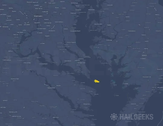
The Lexington Park, MD hail swath map preview was last reviewed on August 27, 2026 and shows mapped hail estimates up to 1.00". There are 0 public hail reports, 51 public wind reports, and 0 nearby tornado reports listed for the May 4, 2021 event.
View the May 4, 2021 Lexington Park, MD hail event on the free interactive hail map, then check a free Hail Report by ZIP to see a more local hail signal for your area.
Impact Area and Population for the Lexington Park, MD Hail Map
The May 4, 2021 hail swath map for Lexington Park, MD covers approximately 522 square miles and includes an estimated 107,630 people inside the mapped footprint. The largest mapped area is in the < 0.50" hail band, covering 257 square miles. The highest estimated population exposure is in the < 0.50" hail band with 31,966 people.
| Mapped Hail Band | Impact Area | Population |
|---|---|---|
| < 0.50" | 257 sq mi | 31,966 |
| 0.50-0.75" | 201 sq mi | 30,028 |
| 0.75-1.00" | 55 sq mi | 28,333 |
| 1.00-1.25" | 10 sq mi | 17,303 |
Get a free Hail Report by ZIP to see a more local hail signal and whether the May 4, 2021 Lexington Park, MD hail event may have reached your area.
Housing Exposure Inside the Lexington Park, MD Hail Swath Map
Inside the May 4, 2021 hail swath map area for Lexington Park, MD, HailGeeks estimates 35,908 single-family homes, 11,620 townhomes, and 9,919 multifamily properties within the mapped storm footprint. Single-family-home exposure is highest in the < 0.50" hail band, with 12,717 single-family homes.
| Mapped Hail Band | Single-Family | Townhomes | Multifamily |
|---|---|---|---|
| < 0.50" | 12,717 | 2,338 | 1,564 |
| 0.50-0.75" | 11,796 | 2,847 | 1,676 |
| 0.75-1.00" | 8,327 | 3,479 | 2,667 |
| 1.00-1.25" | 3,068 | 2,956 | 4,012 |
Use this table to review housing exposure by hail band for the May 4, 2021 Lexington Park, MD hail map. To check a specific property more closely, use a free Hail Report by Address.
Counties Inside the Lexington Park, MD Hail Map
Hail from the May 4, 2021 storm was mapped across 17 counties in the Lexington Park, MD region. Charles County, MD had the strongest mapped signal, peaking at 1.00" with roughly 11,071 single-family homes inside the swath.
County pages group every mapped hail event in the area. For a closer look, drop to the city or ZIP level below, or run a free Hail Report by Address.
Cities Inside the Lexington Park, MD Hail Map
Zooming in, the swath touched 16 cities near Lexington Park, MD. Woodbridge, VA had the strongest mapped signal at 1.00", with an estimated 3,615 single-family homes exposed.
City cards show where the May 4, 2021 Lexington Park, MD hail activity was mapped, but your ZIP can show a closer local signal. Get a free Hail Report by ZIP, and if the signal looks meaningful, ask a local pro about a Remote Hail Inspection to see whether an on-site roof or exterior review may be worth scheduling.
ZIP Codes Inside the Lexington Park, MD Hail Swath Map
At the ZIP level, the May 4, 2021 Lexington Park, MD hail map spans 41 ZIP codes. ZIP 22191 shows the strongest local signal, with mapped hail estimates up to 1.00" and an estimated single-family-home exposure of 7,734.
Check your ZIP in seconds to see whether hail activity from the May 4, 2021 Lexington Park, MD event was mapped near your area.
Public Hail, Wind, and Tornado Reports
Public storm report tables connected to the May 4, 2021 hail map for Lexington Park, MD currently list 0 public hail reports, 51 public wind reports, and 0 tornado reports.
| Date & Time | Hail Size | City | State | Description |
|---|---|---|---|---|
| No public hail reports are available for this event. | ||||
| Date & Time | Wind Speed | City | State | Description |
|---|---|---|---|---|
May 4, 2021 3:30 PM CT | 3 W Oakton | VA | DOWNED TREE BLOCKING FOX MILL RD | |
May 4, 2021 3:39 PM CT | 1 SW Vienna | VA | LARGE TREE UPROOTED AT RESIDENCE... CAUSING ROOF/WALL/SIDING DAMAGE TO CORNER OF HOUSE | |
May 4, 2021 3:44 PM CT | 2 W Annandale | VA | DOWNED TREE BLOCKING EASTBOUND LANES OF LITTLE RIVER TPK | |
May 4, 2021 4:00 PM CT | 1 E Mount Vernon | VA | TREE REPORTED DOWN ON THE 3200 BLOCK OF WOODLAND LANE. | |
May 4, 2021 4:00 PM CT | National Zoo | DC | TREE DOWN ON KLINGLE RD AND ADAMS MILL RD | |
May 4, 2021 4:01 PM CT | 2 E Mount Vernon | VA | TREE REPORTED DOWN ON THE 8600 BLOCK OF STOCKTON PARKWAY. | |
May 4, 2021 4:03 PM CT | 2 SSE Hybla Valley | VA | TREE REPORTED DOWN ON THE 8600 BLOCK OF FORT HUNT ROAD. | |
May 4, 2021 4:09 PM CT | National Zoo | DC | TREE DOWN ON KLINGLE RD AND ADAMS MILL RD | |
May 4, 2021 4:17 PM CT | 1 SSW National Arboretu | DC | TREE DOWN AT 500 21ST ST NE | |
May 4, 2021 4:20 PM CT | 2 SSW Corbin | VA | CHICKEN COOP BLOWN APPROXIMATELY 50 FEET. DOG KENNELS WERE BLOWN SEVERAL FEET. | |
May 4, 2021 4:22 PM CT | 1 NNW Coral Hills | DC | TREE DOWN AT 5037 CALL PLACE SE | |
May 4, 2021 4:25 PM CT | 1 S Villboro | VA | TREES DOWN WIDESPREAD ACROSS CAROLINE COUNTY. FREDERICKSBURG HIGHWAY BLOCKED ALONG WITH SEVERAL OTHER ROADS. | |
May 4, 2021 4:28 PM CT | Bowling Green | VA | BUSINESS 301 CLOSED DUE TO FALLEN TREES. | |
May 4, 2021 4:35 PM CT | 1 WSW Port Royal | VA | TREES DOWN ALONG TIDEWATER TRAIL BLOCKING SEVERAL SECTION OF THE HIGHWAY. | |
May 4, 2021 4:38 PM CT | King George | VA | FENCING WAS DAMAGED AT A PLANTATION ALONG AMBASSADOR LN. | |
May 4, 2021 4:38 PM CT | 1 NNE Dogue | VA | FENCING WAS DAMAGED AT A PLANTATION ALONG AMBASSADOR LN. | |
May 4, 2021 4:42 PM CT | 2 N Jersey | VA | TREE DOWN BLOCKING THE WESTBOUND LANE NEAR THE INTERSECTION OF KINGS HWY AND CANTERBURY LOOP | |
May 4, 2021 4:43 PM CT | 1 NE Glen Allen | VA | LARGE TREE DOWNED. | |
May 4, 2021 4:47 PM CT | 2 SSE Jersey | VA | TREE DOWN ON THE 16000 BLOCK OF NANZATICO LANE | |
May 4, 2021 4:50 PM CT | 3 W Oak Grove | VA | TREES ARE DOWN AND POWER LINES ARE IN THE ROADWAY ON RT 634 CLAYMONT ROAD. | |
May 4, 2021 4:52 PM CT | Oak Grove | VA | TREES AND POWER LINES DOWN BLOCKING VA ROUTE 3 NEAR OAK GROVE RD. | |
May 4, 2021 4:52 PM CT | King George | VA | TREE DOWN ON THE 10000 BLOCK OF INDIANTOWN ROAD | |
May 4, 2021 4:53 PM CT | 2 W Mechanicsville | VA | TREE DOWN. | |
May 4, 2021 4:55 PM CT | Oak Grove | VA | TREES AND POWER LINES ARE DOWN AT INTERSECTION OF KINGS HIGHWAY AND LEEDSTOWN RD. | |
May 4, 2021 4:57 PM CT | 2 SE Dogue | VA | TREE DOWN ON THE 14300 BLOCK OF MILLBANK ROAD | |
May 4, 2021 4:58 PM CT | 1 NNW Shiloh | VA | TREE AND POWERLINE DOWN ON THE 12400 BLOCK OF BEAVER DRIVE | |
May 4, 2021 4:59 PM CT | Shiloh | VA | TREE DOWN NEAR THE INTERSECTION OF KINGS HWY AND BIG TIMBER ROAD | |
May 4, 2021 5:05 PM CT | 3 SW Chaptico | MD | TREE REPORTED DOWN ON THE 36000 BLOCK OF BAY DRIVE. | |
May 4, 2021 5:05 PM CT | 4 E Tompkinsville | MD | MULTIPE TREES REPORTED DOWN ON NOTLEY HALL ROAD. | |
May 4, 2021 5:06 PM CT | 4 WNW Oakley | MD | A FEW TREES SNAPPED AND UPROOTED ON NOTLEY HALL ROAD. | |
May 4, 2021 5:07 PM CT | 3 NW Oakley | MD | TWO TREES REPORTED DOWN ON THE 2200 BLOCK OF BUSHWOOD ROAD. | |
May 4, 2021 5:20 PM CT | King George | VA | LARGE TREE BRANCH DOWN ACROSS ROAD NEAR THE INTERSECTION OF MILLBANK ROAD AND ST. ANTHONY'S ROAD | |
May 4, 2021 5:35 PM CT | 2 WSW Dahlgren | VA | TREE DOWN BLOCKING ROAD NEAR THE INTERSECTION OF WASHINGTON MILL ROAD AND WINDSOR DRIVE | |
May 4, 2021 5:38 PM CT | 1 WSW Dogue | VA | TREE AND POWERLINE DOWN ON THE 6000 BLOCK OF BERRY PLAINS LANDING | |
May 4, 2021 5:40 PM CT | 3 WSW Jersey | VA | TREE DOWN ON THE 16000 BLOCK OF JAMES MADISON PARKWAY | |
May 4, 2021 5:48 PM CT | 4 NNE Honga | MD | NUMEROUS POWER OUTAGES REPORTED BY CHOPTANK ELECTRIC COOPERATIVE. | |
May 4, 2021 5:55 PM CT | Samos | VA | TREE DOWN AT RAINBOW LANE AND WATER VIEW RD IN WATER VIEW VA. | |
May 4, 2021 5:59 PM CT | 1 WSW Linkwood | MD | NUMEROUS POWER OUTAGES REPORTED BY CHOPTANK ELECTRIC COOPERATIVE. | |
May 4, 2021 6:13 PM CT | 3 ESE Mollusk | VA | WIND DAMAGE AT THE END OF MERRY POINT ROAD. | |
May 4, 2021 6:15 PM CT | Lancaster | VA | TREES AND POWER LINES DOWN ACROSS LANCASTER. | |
May 4, 2021 6:15 PM CT | Jersey | VA | LARGE TREE BRANCH IN ROADWAY ON 12000 BLOCK OF JERSEY ROAD | |
May 4, 2021 6:18 PM CT | 2 WNW Kilmarnock | VA | TREES DOWN ON HOUSES ALONG QUARTERS COVE DRIVE. | |
May 4, 2021 6:19 PM CT | 2 W Kilmarnock | VA | WIND DAMAGE ALONG BLACK STUMP ROAD. | |
May 4, 2021 6:24 PM CT | 1 NNW Kilmarnock | VA | STATE ROUTE 3 CLOSED AT JAMES B JONES MEMORIAL HWY NORTH OF KILMARNOCK. | |
May 4, 2021 6:25 PM CT | 2 NW Seaford | DE | CORRECTS TIME OF PREVIOUS TSTM WND DMG REPORT FROM 2 NW SEAFORD. DELAYED REPORT. TREE LIMBS DOWN ON WIRES CAUSED A POWER OUTAGE NEAR ATLANTA RD. TIME ESTIMATED FROM RADAR. | |
May 4, 2021 6:26 PM CT | 2 WNW Ninde | VA | NUMEROUS LARGE TREE BRANCHES DOWN NEAR THE INTERSECTION OF POPLAR NECK ROAD AND TEAL LANE | |
May 4, 2021 6:35 PM CT | Salisbury | MD | POWERLINE KNOCKED DOWN ALONG MT HERMAN ROAD. | |
May 4, 2021 7:40 PM CT | 2 NW Seaford | DE | DELAYED REPORT. TREE LIMBS DOWN ON WIRES CAUSED A POWER OUTAGE NEAR ATLANTA RD. TIME ESTIMATED FROM RADAR. | |
May 4, 2021 4:58 PM CT | 70 mph | 5 S Swan Point | VA | No National Weather Service description provided. |
May 4, 2021 4:59 PM CT | 67 mph | 3 S Tompkinsville | MD | HOME WEATHER STATION ON WOODLAND POINT |
May 4, 2021 5:01 PM CT | 62 mph | 2 SE Cobb Island | MD | No National Weather Service description provided. |
| Date & Time | Rating | City | State | Description |
|---|---|---|---|---|
| No public tornado reports are available for this event. | ||||
This table includes only public storm reports connected to the May 4, 2021 Lexington Park, MD storm event. When available, each report may include the time, size or magnitude, city, state, and a short description.
Related Hail Maps in the Lexington Park, MD Region
We found 3 more hail maps with reports from the same Lexington Park, MD region as the May 4, 2021 event. These related maps cover storm dates from Jan 15, 2021 through Apr 21, 2021, with mapped hail estimates ranging from 1.00" to 1.50". In this set, the strongest related map reached 1.50", and the most recent map shown is from Apr 21, 2021.


If none of these related Lexington Park, MD hail maps look close enough to your property, check a free Hail Report by Address. It reviews hail history for a specific location — not just the broader Lexington Park, MD region — so you can check whether hail activity may have reached your property.
Local Hail Review Options Near Lexington Park, MD
Not sure whether the May 4, 2021 Lexington Park, MD hail map matters for your property? Start with a free Hail Report by Address to see whether hail activity was mapped for that property. If the property signal looks meaningful, you can choose a local pro serving the Lexington Park, MD region and ask about a Remote Hail Inspection before deciding whether an on-site roof or exterior review is worth scheduling.
Check a specific property to see whether hail activity from the May 4, 2021 Lexington Park, MD event — or another recent hail event — may have been mapped at that address.
Find a roof or exterior pro serving the Lexington Park, MD region who can help you understand what the property hail signal may mean.
A participating local pro reviews property-level hail history remotely — not just the May 4, 2021 event — to help decide whether an on-site inspection may be worth scheduling.
A free Hail Report by Address and a Remote Hail Inspection can help you look beyond the May 4, 2021 hail map visuals alone. They do not confirm property damage and do not replace an on-site inspection for a property in the Lexington Park, MD region, but they can help you make a more informed next decision before anyone climbs on the roof.
Frequently Asked Questions
Common questions about the May 4, 2021 Lexington Park, MD hail event.