

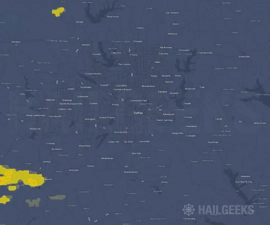
Hail Swath Map Preview
The Dallas, TX hail swath map preview was last reviewed on August 27, 2026 and shows mapped hail estimates up to 1.00". There are 7 public hail reports, 3 public wind reports, and 5 nearby tornado reports listed for the March 21, 2022 event.
View the March 21, 2022 Dallas, TX hail event on the free interactive hail map, then check a free Hail Report by ZIP to see a more local hail signal for your area.
Impact Area and Population for the Dallas, TX Hail Map
The March 21, 2022 hail swath map for Dallas, TX covers approximately 1,163 square miles and includes an estimated 734,191 people inside the mapped footprint. The largest mapped area is in the < 0.50" hail band, covering 609 square miles. The highest estimated population exposure is in the < 0.50" hail band with 313,638 people.
| Mapped Hail Band | Impact Area | Population |
|---|---|---|
| < 0.50" | 609 sq mi | 313,638 |
| 0.50-0.75" | 436 sq mi | 311,369 |
| 0.75-1.00" | 104 sq mi | 93,875 |
| 1.00-1.25" | 14 sq mi | 15,309 |
Get a free Hail Report by ZIP to see a more local hail signal and whether the March 21, 2022 Dallas, TX hail event may have reached your area.
Housing Exposure Inside the Dallas, TX Hail Swath Map
Inside the March 21, 2022 hail swath map area for Dallas, TX, HailGeeks estimates 279,428 single-family homes, 10,196 townhomes, and 87,311 multifamily properties within the mapped storm footprint. Single-family-home exposure is highest in the 0.50-0.75" hail band, with 119,337 single-family homes.
| Mapped Hail Band | Single-Family | Townhomes | Multifamily |
|---|---|---|---|
| < 0.50" | 112,549 | 4,190 | 45,341 |
| 0.50-0.75" | 119,337 | 5,033 | 33,009 |
| 0.75-1.00" | 40,955 | 908 | 6,189 |
| 1.00-1.25" | 6,587 | 65 | 2,772 |
Use this table to review housing exposure by hail band for the March 21, 2022 Dallas, TX hail map. To check a specific property more closely, use a free Hail Report by Address.
Counties Inside the Dallas, TX Hail Map
Hail from the March 21, 2022 storm was mapped across 19 counties in the Dallas, TX region. Tarrant County, TX had the strongest mapped signal, peaking at 1.00" with roughly 112,678 single-family homes inside the swath.
County pages group every mapped hail event in the area. For a closer look, drop to the city or ZIP level below, or run a free Hail Report by Address.
Cities Inside the Dallas, TX Hail Map
Zooming in, the swath touched 45 cities near Dallas, TX. Fort Worth, TX had the strongest mapped signal at 1.00", with an estimated 62,515 single-family homes exposed.
City cards show where the March 21, 2022 Dallas, TX hail activity was mapped, but your ZIP can show a closer local signal. Get a free Hail Report by ZIP, and if the signal looks meaningful, ask a local pro about a Remote Hail Inspection to see whether an on-site roof or exterior review may be worth scheduling.
ZIP Codes Inside the Dallas, TX Hail Swath Map
At the ZIP level, the March 21, 2022 Dallas, TX hail map spans 64 ZIP codes. ZIP 76244 shows the strongest local signal, with mapped hail estimates up to 1.00" and an estimated single-family-home exposure of 17,096.
Check your ZIP in seconds to see whether hail activity from the March 21, 2022 Dallas, TX event was mapped near your area.
Public Hail, Wind, and Tornado Reports
Public storm report tables connected to the March 21, 2022 hail map for Dallas, TX currently list 7 public hail reports, 3 public wind reports, and 5 tornado reports.
| Date & Time | Hail Size | City | State | Description |
|---|---|---|---|---|
March 21, 2022 5:37 PM CT |
1.00 in | White Settlement | TX | WHITE SETTLEMENT REPORTING QUARTER SIZED HAIL AT THIS TIME. |
March 21, 2022 6:02 PM CT |
1.00 in | 2 WSW Westlake | TX | DELAYED REPORT: 1 INCH HAIL REPORTED APPROXIMATE 0.5 TO 1 MILE SOUTH OF ROANOKE RD. |
March 21, 2022 6:09 PM CT |
1.00 in | Trophy Club | TX | REPORT FROM MPING: QUARTER (1.00 IN.). |
March 21, 2022 6:31 PM CT |
1.00 in | 1 SW Corinth | TX | REPORT FROM MPING: QUARTER (1.00 IN.). |
March 21, 2022 6:39 PM CT |
1.00 in | 1 S Hackberry | TX | REPORT FROM MPING: QUARTER (1.00 IN.). |
March 21, 2022 6:45 PM CT |
1.00 in | 2 NE Little Elm | TX | QUARTER SIZED HAIL REPORTED NEAR LITTLE ELM. |
March 21, 2022 6:45 PM CT |
1.00 in | 4 E Lincoln Park | TX | QUARTER SIZE HAIL REPORTED NEAR LINCOLN PARK IN DENTON COUNTY. |
| Date & Time | Wind Speed | City | State | Description |
|---|---|---|---|---|
March 21, 2022 5:59 PM CT | 6 WSW Valley View | TX | CORRECTS PREVIOUS TSTM WND DMG REPORT FROM 6 WSW VALLEY VIEW. REPORTED PROPERTY DAMAGE CR 321 IN COOKE COUNTY NEW INFORMATION 6:06 PM: FIRE ON SCENE CONFIRMED BAR[N] DESTROYED... SHINGLES OFF... ALL WINDOW BLOWN OUT CR 321..COOKE COUNTY. | |
March 21, 2022 6:30 PM CT | 2 SSW Carrollton | TX | MINOR DAMAGE OCCURRED TO THE WOODY BUILDING IN CARROLLTON NEAR I-35E AND BELT LINE. DAMAGE ALSO OCCURRED TO RAILROAD CROSSING GATES NEARBY. TIME ESTIMATED FROM RADAR. | |
March 21, 2022 5:45 PM CT | 58 mph | 1 NW Westworth | TX | DELAYED REPORT: NAS JOINT RESERVE BASE ASOS MEASURED 58 MPH AT 5:45 PM. |
| Date & Time | Rating | City | State | Description |
|---|---|---|---|---|
March 21, 2022 4:47 PM CT | UNK | 5 S Decatur | TX | THE TORNADO FORMED SOUTHEAST OF PARADISE... NEAR WISE COUNTY ROAD 4287... WHERE IT PRODUCED STRUCTURAL DAMAGE TO MULTIPLE HOMES. THE TORNADO TRACKED NORTHEAST APPROXIMATELY 5 MILES... PRODUCING DAMAGE TO SEVERAL HOMES AND OUTBUILDINGS. THE TORNADO ULTIMATELY MOVED OVER US287 SOUTHEAST OF DECATUR... DAMAGING A LARGE ADVERTISING SIGN ALONG THE HIGHWAY AND IMPACTING A STORAGE BUILDING NEAR US287 AND FM 2264. THE TORNADO APPARENTLY DISSIPATED SHORTLY AFTER CROSSING US287. |
March 21, 2022 5:31 PM CT | UNK | 2 SSW Benbrook | TX | NWS DAMAGE SURVEY... SURVEILLANCE VIDEO... AND CASA RADAR DATA CONFIRMED A BRIEF TORNADO THAT CAUSED DAMAGE TO A MARINA ON THE NORTHWEST SHORE OF LAKE BENBROOK. |
March 21, 2022 5:37 PM CT | UNK | 1 NNE River Oaks | TX | THE TORNADO BEGAN ALONG INSPIRATION LANE IN RIVER OAKS. IT THEN MOVED NORTHEAST AND PRODUCED WIDESPREAD TREE DAMAGE THROUGH A NEIGHBORHOOD JUST SOUTHWEST OF JACKSBORO HIGHWAY. SOME EF1 TORNADO DAMAGE WAS FOUND ON HILLSIDE DRIVE AND CIRCLE RIDGE DRIVE WHERE MULTIPLE TREE TRUNKS WERE SNAPPED AND/OR UPROOTED. AS THE TORNADO CROSSED JACKSBORO HIGHWAY... ADDITIONAL EF0 DAMAGE WAS FOUND BETWEEN 18TH STREET AND 22ND STREET BETWEEN MENEFEE AVENUE AND LONG AVENUE. AS THE STORM CONTINUED NORTHEAST... THE TORNADO LIFTED... BUT ADDITIONAL THUNDERSTORM WIND DAMAGE WAS FOUND DOWNSTREAM ALONG LONG AVENUE BETWEEN DECATUR AVENUE AND DEEN ROAD IN FORT WORTH. |
March 21, 2022 6:12 PM CT | UNK | 1 W Euless | TX | CORRECTS PREVIOUS TORNADO REPORT FROM 1 W EULESS. DAMAGE SURVEY AND DOPPLER RADAR DATA CONFIRM THAT AN EF0 TORNADO WITH PEAK WINDS OF 85 MPH STRUCK THE CITY OF EULESS AROUND 6:10 P.M. CDT ON MONDAY... MARCH 21... 2022. THE DAMAGE PATH WAS SOMEWHAT SPORADIC... BUT IN A CORRIDOR THAT LINED UP WELL WITH A STRONG VELOCITY COUPLET SEEN IN DOPPLER RADAR DATA. FURTHERMORE... EYEWITNESSES FROM THE EULESS FIRE DEPARTMENT ON HARWOOD RD REPORTED OBSERVING A FUNNEL CLOUD TO THE SOUTH OF THEIR LOCATION AND ABOVE THE EVENTUAL DAMAGE PATH. THE DAMAGE PATH BEGAN ALONG ECTOR DR AND TRACKED GENERALLY TOWARDS THE NORTHEAST WITH THE MOST SIGNIFICANT DAMAGE NOTED ALONG MILAM DR AND HARRIS DR. DAMAGE MOSTLY CONSISTED OF TREES LIMBS DOWN... THOUGH A FEW LARGER TREES WERE BLOWN OVER AS WELL. STRUCTURAL DAMAGE WAS MINIMAL AND GENERALLY ONLY OCCURRED WHEN TREES FELL ON TOP OF HOMES. THE DAMAGE PATH ENDED NEAR THE INTERSECTION OF HARWOOD DR AND N EULESS MAIN. RADAR DATA SUGGESTS THAT THE TORNADO WAS ON THE GROUND NO LO |
March 21, 2022 6:31 PM CT | UNK | 1 NNW Carrollton | TX | A BRIEF EF-0 TORNADO TOUCHED DOWN IN NORTHERN CARROLLTON AROUND 6:31PM. THE TORNADO INITIALLY CAUSED DAMAGE TO A BUILDING AT THE HILLSIDE COMMUNITY APARTMENTS JUST EAST OF OLD DENTON ROAD AND SOUTH OF ROSEMEADE PARKWAY. IT UPLIFTED A SMALL SECTION OF A ROOFTOP EXPOSING THE INTERIOR OF THE BUILDING... WHILE ALSO REMOVING A LARGE SECTION OF SHINGLING NEARBY. THE TORNADO THEN TRACKED NORTHEASTWARD TOWARDS ROSEMEADE ELEMENTARY SCHOOL WHERE IT SNAPPED TWO LARGE TREES NEAR THE GROUND WHICH FELL IN A CONVERGENT PATTERN. THE TORNADO WAS LIKELY IN PROGRESS FOR A MINUTE OR LESS... WITH ESTIMATED PEAK WINDS NEAR 85 MPH. |
This table includes only public storm reports connected to the March 21, 2022 Dallas, TX storm event. When available, each report may include the time, size or magnitude, city, state, and a short description.
Related Hail Maps in the Dallas, TX Region
We found 6 more hail maps with reports from the same Dallas, TX region as the March 21, 2022 event. These related maps cover storm dates from Oct 13, 2021 through Mar 14, 2022, with mapped hail estimates ranging from 0.75" to 2.75". In this set, the strongest related map reached 2.75", and the most recent map shown is from Mar 14, 2022.




If none of these related Dallas, TX hail maps look close enough to your property, check a free Hail Report by Address. It reviews hail history for a specific location — not just the broader Dallas, TX region — so you can check whether hail activity may have reached your property.
Local Hail Review Options Near Dallas, TX
Not sure whether the March 21, 2022 Dallas, TX hail map matters for your property? Start with a free Hail Report by Address to see whether hail activity was mapped for that property. If the property signal looks meaningful, you can choose a local pro serving the Dallas, TX region and ask about a Remote Hail Inspection before deciding whether an on-site roof or exterior review is worth scheduling.
Check a specific property to see whether hail activity from the March 21, 2022 Dallas, TX event — or another recent hail event — may have been mapped at that address.
Find a roof or exterior pro serving the Dallas, TX region who can help you understand what the property hail signal may mean.
A participating local pro reviews property-level hail history remotely — not just the March 21, 2022 event — to help decide whether an on-site inspection may be worth scheduling.
A free Hail Report by Address and a Remote Hail Inspection can help you look beyond the March 21, 2022 hail map visuals alone. They do not confirm property damage and do not replace an on-site inspection for a property in the Dallas, TX region, but they can help you make a more informed next decision before anyone climbs on the roof.
Frequently Asked Questions
Common questions about the March 21, 2022 Dallas, TX hail event.