

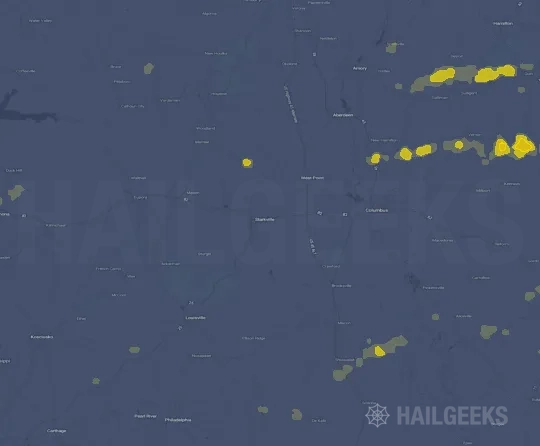
Hail Swath Map Preview
The Starkville, MS hail swath map preview was last reviewed on August 27, 2026 and shows mapped hail estimates up to 1.00". There are 0 public hail reports, 19 public wind reports, and 8 nearby tornado reports listed for the March 22, 2022 event.
View the March 22, 2022 Starkville, MS hail event on the free interactive hail map, then check a free Hail Report by ZIP to see a more local hail signal for your area.
Impact Area and Population for the Starkville, MS Hail Map
The March 22, 2022 hail swath map for Starkville, MS covers approximately 405 square miles and includes an estimated 7,252 people inside the mapped footprint. The largest mapped area is in the < 0.50" hail band, covering 267 square miles. The highest estimated population exposure is in the < 0.50" hail band with 5,411 people.
| Mapped Hail Band | Impact Area | Population |
|---|---|---|
| < 0.50" | 267 sq mi | 5,411 |
| 0.50-0.75" | 117 sq mi | 1,629 |
| 0.75-1.00" | 19 sq mi | 192 |
| 1.00-1.25" | 2 sq mi | 20 |
Get a free Hail Report by ZIP to see a more local hail signal and whether the March 22, 2022 Starkville, MS hail event may have reached your area.
Housing Exposure Inside the Starkville, MS Hail Swath Map
Inside the March 22, 2022 hail swath map area for Starkville, MS, HailGeeks estimates 3,477 single-family homes, 35 townhomes, and 592 multifamily properties within the mapped storm footprint. Single-family-home exposure is highest in the < 0.50" hail band, with 2,579 single-family homes.
| Mapped Hail Band | Single-Family | Townhomes | Multifamily |
|---|---|---|---|
| < 0.50" | 2,579 | 24 | 472 |
| 0.50-0.75" | 796 | 11 | 115 |
| 0.75-1.00" | 93 | 0 | 5 |
| 1.00-1.25" | 9 | 0 | 0 |
Use this table to review housing exposure by hail band for the March 22, 2022 Starkville, MS hail map. To check a specific property more closely, use a free Hail Report by Address.
Counties Inside the Starkville, MS Hail Map
Hail from the March 22, 2022 storm was mapped across 13 counties in the Starkville, MS region. Noxubee County, MS had the strongest mapped signal, peaking at 1.00" with roughly 835 single-family homes inside the swath.
County pages group every mapped hail event in the area. For a closer look, drop to the city or ZIP level below, or run a free Hail Report by Address.
Cities Inside the Starkville, MS Hail Map
Zooming in, the swath touched 6 cities near Starkville, MS. Macon, MS had the strongest mapped signal at 0.50", with an estimated 374 single-family homes exposed.
City cards show where the March 22, 2022 Starkville, MS hail activity was mapped, but your ZIP can show a closer local signal. Get a free Hail Report by ZIP, and if the signal looks meaningful, ask a local pro about a Remote Hail Inspection to see whether an on-site roof or exterior review may be worth scheduling.
ZIP Codes Inside the Starkville, MS Hail Swath Map
At the ZIP level, the March 22, 2022 Starkville, MS hail map spans 11 ZIP codes. ZIP 39354 shows the strongest local signal, with mapped hail estimates up to 1.00" and an estimated single-family-home exposure of 112.
Check your ZIP in seconds to see whether hail activity from the March 22, 2022 Starkville, MS event was mapped near your area.
Public Hail, Wind, and Tornado Reports
Public storm report tables connected to the March 22, 2022 hail map for Starkville, MS currently list 0 public hail reports, 19 public wind reports, and 8 tornado reports.
| Date & Time | Hail Size | City | State | Description |
|---|---|---|---|---|
| No public hail reports are available for this event. | ||||
| Date & Time | Wind Speed | City | State | Description |
|---|---|---|---|---|
March 22, 2022 1:30 PM CT | 1 NW Carmack | MS | TREES DOWN HIGHWAY 35 AND COUNTY ROAD 3132. POSSIBLE TORNADO. | |
March 22, 2022 1:37 PM CT | 3 E Elliott | MS | TREES DOWN ACROSS SOUTHERN GRENADA COUNTY. | |
March 22, 2022 1:37 PM CT | 3 ENE Poplar Creek | MS | TREES DOWNED ALONG MS 413 IN SOUTHEASTERN MONTGOMERY CO. | |
March 22, 2022 1:44 PM CT | French Camp | MS | TREES WERE BLOWN DOWN ON THE NATCHEZ TRACE PARKWAY AT MILE MARKER 180 NEAR FRENCH CAMP. | |
March 22, 2022 2:04 PM CT | 2 SSE Marydell | MS | A COUPLE TREES WERE DOWNED ACROSS EASTERN PORTIONS OF THE COUNTY. | |
March 22, 2022 2:06 PM CT | Reform | MS | MULTIPLE TREES DOWNED ACROSS THE COUNTY. | |
March 22, 2022 2:08 PM CT | 5 WSW Plattsburg | MS | SOCIAL MEDIA REPORT OF TREES DOWN ALONG HWY 19 IN NORTHWEST NESHOBA COUNTY. | |
March 22, 2022 2:11 PM CT | 2 E Starkville | MS | OAK TREE DOWN ON MSU CAMPUS. REPORT RELAYED THROUGH SOCIAL MEDIA. | |
March 22, 2022 2:29 PM CT | 1 ENE Louisville | MS | SOCIAL MEDIA REPORT OF SEVERAL TREES DOWN IN THE LOUISVILLE AREA. | |
March 22, 2022 2:49 PM CT | 2 E Starkville | MS | CORRECTS PREVIOUS TSTM WND DMG REPORT FROM 2 E STARKVILLE. OAK TREES DOWNED OR SNAPPED ON MSU CAMPUS. TWO CARS WERE DAMAGED. REPORT RELAYED THROUGH SOCIAL MEDIA. | |
March 22, 2022 2:59 PM CT | 2 ENE Osborn | MS | TREES DOWN ALONG OLD WEST POINT RD. | |
March 22, 2022 3:03 PM CT | 3 WSW Nettleton | MS | BARN ROOF WAS REMOVED. | |
March 22, 2022 3:13 PM CT | 7 WSW New Hamilton | MS | TREES DOWN ALONG LAKEVIEW DR. POSSIBLE TORNADO. | |
March 22, 2022 3:15 PM CT | 5 WSW New Hamilton | MS | TREES SNAPPED AND POWER LINES DOWN ALONG STRONG ROAD AND DARRACOTT ROAD. POSSIBLE TORNADO. | |
March 22, 2022 3:27 PM CT | 4 W Prairie Point | MS | POWER POLES WERE SNAPPED AND SEVERAL TREES WERE DOWN. | |
March 22, 2022 3:40 PM CT | 4 NNW Gattman | MS | LARGE TREE SNAPPED AND POWER LINES DOWN OFF OF SPLUNGE ROAD. | |
March 22, 2022 3:40 PM CT | 3 N Pickensville | AL | LARGE TREE DOWN ACROSS HWY 14 NEAR PICKENSVILLE. | |
March 22, 2022 3:45 PM CT | 7 N Gattman | MS | PART OF A ROOF AND SOME SIDE TIN WAS BLOWN OFF A BARN ON SIPSEY-DETROIT ROAD. | |
March 22, 2022 3:45 PM CT | 1 W Detroit | AL | EMERGENCY MANAGER REPORTS A FEW TREES DOWN ACROSS THE COUNTY. |
| Date & Time | Rating | City | State | Description |
|---|---|---|---|---|
March 22, 2022 2:45 PM CT | UNK | Moscow | MS | REPORT AND VIDEO RELAYED VIA SOCIAL MEDIA. |
March 22, 2022 3:04 PM CT | UNK | 3 S West Point | MS | THIS F1 TORNADO BEGAN NEAR OLD TIBBEE RD AND SECTION RD ON THE SOUTHEAST SIDE OF WEST POINT... THEN TRACKED NORTHEASTWARD TO JUST EAST OF WEST POINT. IT THEN CONTINUED ACROSS EASTERN CLAY COUNTY AND CROSSED INTO SOUTHERN MONROE COUNTY. ESTIMATED MAXIMUM WIND 105 MPH. MAXIMUM PATH WIDTH 650 YARDS. PATH LENGTH IN CLAY COUNTY WAS 9.4 MILES. |
March 22, 2022 3:09 PM CT | UNK | 2 ESE West Point | MS | CORRECTS TIME OF PREVIOUS TORNADO REPORT FROM 2 ESE WEST POINT. TORNADO DAMAGE TO TREES... POWER POLES ALSO SNAPPED... AND METAL POLES BENT AT A BUSINESS. THERE WERE NO REPORTS OF INJURIES. STREETS INCLUDE WAVERLY RD... CHURCHILL ST... ESHMAN ST... CONCORDE RD... HWY 50. |
March 22, 2022 3:12 PM CT | UNK | 3 W New Hamilton | MS | THE CLAY COUNTY... MISSISSIPPI TORNADO CONTINUED TO MOVE NORTHEAST INTO MONROE COUNTY... MISSISSIPPI. THE MOST SIGNIFICANT DAMAGE OCCURRED SOUTH OF STRONG ROAD ON LAKEVIEW DRIVE WHERE SEVERAL TREES WERE SNAPPED ALONG WITH A BROKEN POWER POLE. ADDITIONAL TREE DAMAGE FOUND UP TO 3 MILES WNW OF NEW HAMILTON. |
March 22, 2022 3:16 PM CT | UNK | 5 N Shuqualak | MS | THIS TORNADO BEGAN IN A WOODED AREA JUST WEST OF HIGHWAY 45 AND QUICKLY CROSSED THE HIGHWAY WHERE LARGE LIMBS WERE DOWNED ONTO POWER LINES. THE TORNADO CONTINUED NORTHEAST CROSSING THROUGH A SMALL NEIGHBORHOOD ON THE SOUTHEAST SIDE OF MACON. HERE... ADDITIONAL LARGE LIMBS WERE SNAPPED ON HALL RD... CHEATHAM RD AND ALLEN BEND RD. ANOTHER LARGE LIMB WAS ALSO DOWNED ACROSS HIGHWAY 14. THE TORNADO CONTINUED NORTHEAST THROUGH MAINLY OPEN FARMLAND BEFORE REACHING PRAIRIE POINT RD. SEVERAL LARGE LIMBS WERE SNAPPED HERE ALONG WITH DAMAGE TO A RELATIVELY NEWLY CONSTRUCTED STORAGE SHED. THE TORNADO BRIEFLY INTENSIFIED TO EF-1 STRENGTH WITH 105MPH WINDS AS IT CROSSED DEERBROOK RD SNAPPING APPROXIMATELY NINE POWER POLES. THE TORNADO WEAKENED AND DISSIPATED BY THE TIME IT REACHED GILLESPIE RD WHERE ONLY MINOR DAMAGE TO A CARPORT WAS NOTED. |
March 22, 2022 3:58 PM CT | UNK | 2 ESE West Point | MS | TORNADO DAMAGE TREE DOWN... POWER POLES ALSO SNAPPED... AND METAL POLES BENT AT A BUSINESS. THERE WERE NO REPORTS OF INJURIES. STREETS INCLUDE WAVERLY RD... CHURCHILL ST... ESHMAN ST... CONCORDE RD... HWY 50. |
March 22, 2022 6:00 PM CT | UNK | 1 WNW Thornhill | AL | A BRIEF EF0 TORNADO DOWNED TREES NEAR COUNTY ROAD 20 AND COUNTY ROAD 142. |
March 22, 2022 6:04 PM CT | UNK | 3 NNE Thornhill | AL | AN EF0 TORNADO DOWNED TREES AND CAUSED MINOR ROOF DAMAGE NEAR HIGHWAY 43 AND COUNTY ROAD 148. |
This table includes only public storm reports connected to the March 22, 2022 Starkville, MS storm event. When available, each report may include the time, size or magnitude, city, state, and a short description.
Related Hail Maps in the Starkville, MS Region
We found 6 more hail maps with reports from the same Starkville, MS region as the March 22, 2022 event. These related maps cover storm dates from Aug 11, 2021 through Feb 22, 2022, with mapped hail estimates ranging from 0.75" to 1.75". In this set, the strongest related map reached 1.75", and the most recent map shown is from Feb 22, 2022.



If none of these related Starkville, MS hail maps look close enough to your property, check a free Hail Report by Address. It reviews hail history for a specific location — not just the broader Starkville, MS region — so you can check whether hail activity may have reached your property.
Local Hail Review Options Near Starkville, MS
Not sure whether the March 22, 2022 Starkville, MS hail map matters for your property? Start with a free Hail Report by Address to see whether hail activity was mapped for that property. If the property signal looks meaningful, you can choose a local pro serving the Starkville, MS region and ask about a Remote Hail Inspection before deciding whether an on-site roof or exterior review is worth scheduling.
Check a specific property to see whether hail activity from the March 22, 2022 Starkville, MS event — or another recent hail event — may have been mapped at that address.
Find a roof or exterior pro serving the Starkville, MS region who can help you understand what the property hail signal may mean.
A participating local pro reviews property-level hail history remotely — not just the March 22, 2022 event — to help decide whether an on-site inspection may be worth scheduling.
A free Hail Report by Address and a Remote Hail Inspection can help you look beyond the March 22, 2022 hail map visuals alone. They do not confirm property damage and do not replace an on-site inspection for a property in the Starkville, MS region, but they can help you make a more informed next decision before anyone climbs on the roof.
Frequently Asked Questions
Common questions about the March 22, 2022 Starkville, MS hail event.