

Hail Swath Map Preview
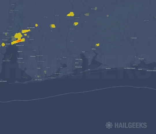
The Pensacola, FL hail swath map preview was last reviewed on August 27, 2026 and shows mapped hail estimates up to 1.75". There are 2 public hail reports, 9 public wind reports, and 6 nearby tornado reports listed for the April 2, 2022 event.
View the April 2, 2022 Pensacola, FL hail event on the free interactive hail map, then check a free Hail Report by ZIP to see a more local hail signal for your area.
Impact Area and Population for the Pensacola, FL Hail Map
The April 2, 2022 hail swath map for Pensacola, FL covers approximately 312 square miles and includes an estimated 944 people inside the mapped footprint. The largest mapped area is in the < 0.50" hail band, covering 186 square miles. The highest estimated population exposure is in the 0.75-1.00" hail band with 178 people.
| Mapped Hail Band | Impact Area | Population |
|---|---|---|
| < 0.50" | 186 sq mi | 130 |
| 0.50-0.75" | 99 sq mi | 124 |
| 0.75-1.00" | 10 sq mi | 178 |
| 1.00-1.25" | 5 sq mi | 178 |
| 1.25-1.50" | 3 sq mi | 101 |
| 1.50-1.75" | 3 sq mi | 85 |
| 1.75-2.00" | 4 sq mi | 148 |
Get a free Hail Report by ZIP to see a more local hail signal and whether the April 2, 2022 Pensacola, FL hail event may have reached your area.
Housing Exposure Inside the Pensacola, FL Hail Swath Map
Inside the April 2, 2022 hail swath map area for Pensacola, FL, HailGeeks estimates 454 single-family homes, 6 townhomes, and 1 multifamily properties within the mapped storm footprint. Single-family-home exposure is highest in the 0.75-1.00" hail band, with 87 single-family homes.
| Mapped Hail Band | Single-Family | Townhomes | Multifamily |
|---|---|---|---|
| < 0.50" | 62 | 0 | 1 |
| 0.50-0.75" | 58 | 1 | 0 |
| 0.75-1.00" | 87 | 2 | 0 |
| 1.00-1.25" | 87 | 2 | 0 |
| 1.25-1.50" | 50 | 1 | 0 |
| 1.50-1.75" | 43 | 0 | 0 |
| 1.75-2.00" | 67 | 0 | 0 |
Use this table to review housing exposure by hail band for the April 2, 2022 Pensacola, FL hail map. To check a specific property more closely, use a free Hail Report by Address.
Counties Inside the Pensacola, FL Hail Map
Hail from the April 2, 2022 storm was mapped across 1 counties in the Pensacola, FL region. Baldwin County, AL had the strongest mapped signal, peaking at 1.75" with roughly 169 single-family homes inside the swath.
County pages group every mapped hail event in the area. For a closer look, drop to the city or ZIP level below, or run a free Hail Report by Address.
Cities Inside the Pensacola, FL Hail Map
Zooming in, the swath touched 0 cities near Pensacola, FL.
City cards show where the April 2, 2022 Pensacola, FL hail activity was mapped, but your ZIP can show a closer local signal. Get a free Hail Report by ZIP, and if the signal looks meaningful, ask a local pro about a Remote Hail Inspection to see whether an on-site roof or exterior review may be worth scheduling.
ZIP Codes Inside the Pensacola, FL Hail Swath Map
At the ZIP level, the April 2, 2022 Pensacola, FL hail map spans 2 ZIP codes. ZIP 36507 shows the strongest local signal, with mapped hail estimates up to 1.75" and an estimated single-family-home exposure of 113.
Check your ZIP in seconds to see whether hail activity from the April 2, 2022 Pensacola, FL event was mapped near your area.
Public Hail, Wind, and Tornado Reports
Public storm report tables connected to the April 2, 2022 hail map for Pensacola, FL currently list 2 public hail reports, 9 public wind reports, and 6 tornado reports.
| Date & Time | Hail Size | City | State | Description |
|---|---|---|---|---|
April 3, 2022 12:30 AM CT |
1.75 in | Pace | FL | PHOTOS RELAYED VIA SOCIAL MEDIA OF A NEARLY GOLF BALL SIZE HAIL STONE. |
April 3, 2022 12:39 AM CT |
1.00 in | Pace | FL | NUMEROUS REPORTS OF HAIL IN THE PACE COMMUNITY. PHOTOS AND VIDEOS RELAYED VIA SOCIAL MEDIA. |
| Date & Time | Wind Speed | City | State | Description |
|---|---|---|---|---|
April 2, 2022 10:58 PM CT | 1 WNW Hollingers Island | AL | REPORTS RELAYED VIA SOCIAL MEDIA OF POWERLINES AND TREES DOWN NEAR HAMILTON BLVD AND RANGELINE RD IN THEODORE... AL. | |
April 2, 2022 11:21 PM CT | Point Clear | AL | PHOTOS RELAYED VIA SOCIAL MEDIA OF SNAPPED TREES AND DEBRIS ON ROADS IN THE POINT CLEAR COMMUNITY. | |
April 3, 2022 12:15 AM CT | Cantonment | FL | BROADCAST MEDIA RELAYED REPORTS OF TREES DOWN AND DAMAGE NEAR THE CANTONMENT COMMUNITY AND ACROSS THE COUNTY LINE IN PACE (SANTA ROSA COUNTY). | |
April 3, 2022 12:42 AM CT | 5 SE Pace | FL | STRUCTURAL DAMAGE REPORTED IN THE AVALON AREA OF MILTON. TREES/POWER LINES DOWN IN ROADS AND YARDS. TREES FELL ON A HOUSE AND A DETACHED GARAGE WAS FLATTENED. | |
April 3, 2022 12:42 AM CT | 4 SW Bagdad | FL | STRUCTURAL DEBRIS REPORTED ALONG AVALON BLVD NEAR THE OLD MOORES GOLF COURSE. TIME ESTIMATED. | |
April 3, 2022 1:14 AM CT | 5 W Galliver | FL | PICTURE OF LARGE OAK TREES DOWNED AT BLACKWATER FISH HATCHERY. TIME ESTIMATED BY RADAR. REPORT VIA SOCIAL MEDIA. | |
April 3, 2022 1:41 AM CT | 4 NE Campton | FL | REPORTS OF TREES AND POWER LINES DOWN ON PLYMPTON ROAD NEAR LAUREL HILL... FL. | |
April 3, 2022 12:40 AM CT | 58 mph | Pensacola International | FL | PENSACOLA ASOS MEASURED A WIND GUST OF 50 KNOTS. |
April 3, 2022 1:41 AM CT | 60 mph | 1 SSE Crestview Airport | FL | CRESTVIEW ASOS MEASURED A WIND GUST OF 52 KNOTS AT 1:35AM CDT. |
| Date & Time | Rating | City | State | Description |
|---|---|---|---|---|
April 2, 2022 11:22 PM CT | UNK | 1 SSE Point Clear | AL | A BRIEF EF0 TORNADO BEGAN NEAR GRASS ROAD AND TRACKED NORTHEAST... CROSSING CALLOWAY DRIVE. THE TORNADO LIFTED BY THE TIME IT REACHED PROVENCHER ROAD JUST SOUTH OF COUNTY ROAD 32. THE TORNADO PRODUCED SPORADIC PINE TREE DAMAGE ALONG ITS PATH. |
April 2, 2022 11:50 PM CT | UNK | 4 ENE Rosinton | AL | A BRIEF... WEAK EF0 TORNADO WITH WINDS UPWARDS OF 75MPH OCCURRED IN BALDWIN COUNTY... ALABAMA JUST NORTHEAST OF ROSINTON 3/30/22. THE TORNADO BEGAN IN A LIMITED ACCESS AREA WHERE A COUPLE FRESHLY SNAPPED TOPS TO PINE TREES WERE NOTED ACROSS THE FIELD. DUE TO LIMITED ROAD ACCESS AND BREVITY OF THE TORNADO... THE PATH AND END POINT ARE ESTIMATED BY RADAR DEBRIS SIGNATURE AND VELOCITY COUPLET DURATION. |
April 3, 2022 12:25 AM CT | UNK | 2 E Gonzalez | FL | A BRIEF... WEAK EF0 TORNADO WITH WINDS UPWARDS OF 80MPH BEGAN IN THE GONZALEZ AREA SHORTLY AFTER MIDNIGHT ON 3/31/22 IMPACTING A RESIDENTIAL AREA FROM CHEMSTRAND ROAD EAST NORTHEAST THROUGH CATERPILLAR LANE AND CRYSTAL DRIVE. THIS TORNADO RESULTED IN MINOR DAMAGE TO FENCING... ROOFS... SIDING... AND A COUPLE UPROOTED/SNAPPED SOFTWOOD TREES IN A WEAK CONVERGENT PATTERN ALONG THE DAMAGE PATH. THE TORNADO LIFTED AT CRYSTAL DRIVE. |
April 3, 2022 12:25 AM CT | UNK | 2 E Gonzalez | FL | REPORT OF LARGE LIMBS DOWN DOING DAMAGE TO FOUR ROOF-TOP SOLAR PANELS. ONE YEAR OLD WOODEN FENCE DOWNED ON PROPERTY. RESIDENT REPORTED LOTS OF WIND BLOWN DEBRIS PLANTED INTO THE SIDE OF HIS HOUSE. NEXT DOOR NEIGHBOR HAD AN UPROOTED TREE ON THEIR PROPERTY. |
April 3, 2022 12:32 AM CT | UNK | 3 NNW Pace | FL | A SHORT DURATION EF1 TORNADO WITH WINDS UPWARDS OF 94MPH IMPACTED THE PACE AREA ON 3/31/22. THIS TORNADO BEGAN ON DOVE DRIVE IMPACTING MULTIPLE RESIDENTIAL STRUCTURES RESULTING IN NOTABLE LOSS OF ROOFING MATERIAL ALONG WITH MANY SNAPPED/UPROOTED SOFTWOOD AND HARDWOOD TREES. THE TORNADO EXITED THE COMMUNITY QUICKLY TRACKING JUST TO THE NORTHWEST OF THE CIRCLE K ON QUINTETTE ROAD WHERE MULTIPLE TREES WERE SNAPPED AND UPROOTED. THE TORNADO LIFTED AT OR NEAR THE BERRYHILL AND CHUMUCKLA HIGHWAY INTERSECTION WHERE THE DAMAGE PATH ENDED. |
April 3, 2022 12:37 AM CT | UNK | 4 E Ferry Pass | FL | *** 2 INJ *** AN EF1 TORNADO BEGAN ON 3/31/22 ALONG THE ESCAMBIA BAY BRIDGE OF I-10 OVERTURNING AN EASTBOUND SEMI-TRUCK RESULTING IN TWO INJURIES. THE TORNADO CONTINUED NORTHEAST MOVING ONSHORE OFF OF ESCAMBIA BAY RESULTING IN VERY SPORADIC MINOR TREE DAMAGE AROUND NORTH 6TH AVENUE. THE TORNADO TURNED EAST NORTHEAST AND PICKED UP IN INTENSITY AS IT UPROOTED AND SNAPPED NUMEROUS HARDWOOD/SOFTWOOD TREES AND CAUSED MINOR TO MODERATE ROOFING DAMAGE TO RESIDENTIAL HOMES. THE TORNADO TRACKED NORTHEAST REACHING ITS PEAK INTENSITY OF 104MPH ALONG DE LA RUE DRIVE WHERE A SMALL TREE STAND HAD MOST OF ITS TREES SNAPPED WITH MULTIPLE UPROOTED AND SNAPPED TREES IN ITS VICINITY. THE TORNADO CONTINUED NORTHEAST FROM HERE CROSSING ANOTHER SMALL RESIDENTIAL COMMUNITY LOCATED ALONG HIGHLAND LAKE RD INTO EDINBURGH CASTLE DRIVE UPROOTING AND SNAPPING MULTIPLE TREES AND REMOVING SOME ROOFING MATERIAL FROM RESIDENTIAL HOMES. THE TORNADO CROSS EDINBURGH CASTLE DRIVE WHERE IT IMPACTED A RESIDENTIAL HOME WH |
This table includes only public storm reports connected to the April 2, 2022 Pensacola, FL storm event. When available, each report may include the time, size or magnitude, city, state, and a short description.
Related Hail Maps in the Pensacola, FL Region
We found 6 more hail maps with reports from the same Pensacola, FL region as the April 2, 2022 event. These related maps cover storm dates from Nov 27, 2021 through Mar 30, 2022, with mapped hail estimates ranging from 0.75" to 2.00". In this set, the strongest related map reached 2.00", and the most recent map shown is from Mar 30, 2022.


If none of these related Pensacola, FL hail maps look close enough to your property, check a free Hail Report by Address. It reviews hail history for a specific location — not just the broader Pensacola, FL region — so you can check whether hail activity may have reached your property.
Local Hail Review Options Near Pensacola, FL
Not sure whether the April 2, 2022 Pensacola, FL hail map matters for your property? Start with a free Hail Report by Address to see whether hail activity was mapped for that property. If the property signal looks meaningful, you can choose a local pro serving the Pensacola, FL region and ask about a Remote Hail Inspection before deciding whether an on-site roof or exterior review is worth scheduling.
Check a specific property to see whether hail activity from the April 2, 2022 Pensacola, FL event — or another recent hail event — may have been mapped at that address.
Find a roof or exterior pro serving the Pensacola, FL region who can help you understand what the property hail signal may mean.
A participating local pro reviews property-level hail history remotely — not just the April 2, 2022 event — to help decide whether an on-site inspection may be worth scheduling.
A free Hail Report by Address and a Remote Hail Inspection can help you look beyond the April 2, 2022 hail map visuals alone. They do not confirm property damage and do not replace an on-site inspection for a property in the Pensacola, FL region, but they can help you make a more informed next decision before anyone climbs on the roof.
Frequently Asked Questions
Common questions about the April 2, 2022 Pensacola, FL hail event.