

Hail Swath Map Preview
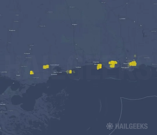
The Gulfport, MS hail swath map preview was last reviewed on August 27, 2026 and shows mapped hail estimates up to 4.00+. There are 0 public hail reports, 5 public wind reports, and 7 nearby tornado reports listed for the April 2, 2022 event.
View the April 2, 2022 Gulfport, MS hail event on the free interactive hail map, then check a free Hail Report by ZIP to see a more local hail signal for your area.
Impact Area and Population for the Gulfport, MS Hail Map
The April 2, 2022 hail swath map for Gulfport, MS covers approximately 356 square miles and includes an estimated 111,696 people inside the mapped footprint. The largest mapped area is in the 0.50-0.75" hail band, covering 137 square miles. The highest estimated population exposure is in the 0.50-0.75" hail band with 37,624 people.
| Mapped Hail Band | Impact Area | Population |
|---|---|---|
| < 0.50" | 93 sq mi | 20,836 |
| 0.50-0.75" | 137 sq mi | 37,624 |
| 0.75-1.00" | 53 sq mi | 16,967 |
| 1.00-1.25" | 28 sq mi | 11,900 |
| 1.25-1.50" | 14 sq mi | 7,151 |
| 1.50-1.75" | 6 sq mi | 1,025 |
| 1.75-2.00" | 3 sq mi | 1,245 |
| 2.00-2.25" | 4 sq mi | 1,699 |
| 2.25-2.50" | 5 sq mi | 2,852 |
| 2.50-2.75" | 3 sq mi | 1,018 |
| 2.75-3.00" | 2 sq mi | 1,126 |
| 3.00-3.25" | 2 sq mi | 2,137 |
| 3.25-3.50" | 5 sq mi | 5,833 |
| 4.00"+ | 2 sq mi | 283 |
Get a free Hail Report by ZIP to see a more local hail signal and whether the April 2, 2022 Gulfport, MS hail event may have reached your area.
Housing Exposure Inside the Gulfport, MS Hail Swath Map
Inside the April 2, 2022 hail swath map area for Gulfport, MS, HailGeeks estimates 53,873 single-family homes, 1,795 townhomes, and 17,820 multifamily properties within the mapped storm footprint. Single-family-home exposure is highest in the 0.50-0.75" hail band, with 16,063 single-family homes.
| Mapped Hail Band | Single-Family | Townhomes | Multifamily |
|---|---|---|---|
| < 0.50" | 9,936 | 470 | 3,511 |
| 0.50-0.75" | 16,063 | 586 | 7,699 |
| 0.75-1.00" | 8,640 | 346 | 3,309 |
| 1.00-1.25" | 6,597 | 102 | 881 |
| 1.25-1.50" | 3,995 | 154 | 1,066 |
| 1.50-1.75" | 475 | 0 | 306 |
| 1.75-2.00" | 581 | 27 | 341 |
| 2.00-2.25" | 825 | 3 | 214 |
| 2.25-2.50" | 1,493 | 17 | 135 |
| 2.50-2.75" | 518 | 2 | 51 |
| 2.75-3.00" | 599 | 16 | 0 |
| 3.00-3.25" | 1,162 | 11 | 1 |
| 3.25-3.50" | 2,855 | 60 | 267 |
| 4.00"+ | 134 | 1 | 39 |
Use this table to review housing exposure by hail band for the April 2, 2022 Gulfport, MS hail map. To check a specific property more closely, use a free Hail Report by Address.
Counties Inside the Gulfport, MS Hail Map
Hail from the April 2, 2022 storm was mapped across 6 counties in the Gulfport, MS region. Hancock County, MS had the strongest mapped signal, peaking at 4.00" with roughly 5,851 single-family homes inside the swath.
County pages group every mapped hail event in the area. For a closer look, drop to the city or ZIP level below, or run a free Hail Report by Address.
Cities Inside the Gulfport, MS Hail Map
Zooming in, the swath touched 21 cities near Gulfport, MS. Mobile, AL had the strongest mapped signal at 3.00", with an estimated 4,199 single-family homes exposed.
City cards show where the April 2, 2022 Gulfport, MS hail activity was mapped, but your ZIP can show a closer local signal. Get a free Hail Report by ZIP, and if the signal looks meaningful, ask a local pro about a Remote Hail Inspection to see whether an on-site roof or exterior review may be worth scheduling.
ZIP Codes Inside the Gulfport, MS Hail Swath Map
At the ZIP level, the April 2, 2022 Gulfport, MS hail map spans 26 ZIP codes. ZIP 39525 shows the strongest local signal, with mapped hail estimates up to 4.00" and an estimated single-family-home exposure of 2,922.
Check your ZIP in seconds to see whether hail activity from the April 2, 2022 Gulfport, MS event was mapped near your area.
Public Hail, Wind, and Tornado Reports
Public storm report tables connected to the April 2, 2022 hail map for Gulfport, MS currently list 0 public hail reports, 5 public wind reports, and 7 tornado reports.
| Date & Time | Hail Size | City | State | Description |
|---|---|---|---|---|
| No public hail reports are available for this event. | ||||
| Date & Time | Wind Speed | City | State | Description |
|---|---|---|---|---|
April 2, 2022 8:05 PM CT | 8 N Rogers Lake | MS | FEW TREES DOWN ON HIGHWAY 26 AT LAKE TOC-O-LEEN AND HIGHWAY 26 AT MAGNOLIA ROAD. TIME ESTIMATED. | |
April 2, 2022 10:34 PM CT | 2 ESE Big Creek Lake | AL | REPORTS OF TREES DOWN AND DAMAGED STRUCTURES NEAR THE WULFF ROAD S AND HOWELLS FERRY RD AREA. | |
April 2, 2022 10:36 PM CT | 2 ESE Big Creek Lake | AL | REPORTS OF TREES DOWN AND DAMAGED STRUCTURES IN THE WULFF ROAD SOUTH/HOWELLS FERRY ROAD AREA. | |
April 2, 2022 10:45 PM CT | 3 SSE Grand Bay | AL | NWS DAMAGE SURVEY FOUND A COUPLE SNAPPED LARGE BRANCHES WITH FEW SNAPPED OR UPROOTED SOFTWOOD TREES. A COUPLE OUT BUILDINGS WITH MOST OF THEIR ROOFS REMOVED AND A MANUFACTURED HOME WITH MINOR ROOF DAMAGE. WINDS ESTIMATED TO BE 75 MPH AND TIME ESTIMATED BY RADAR. | |
April 2, 2022 10:49 PM CT | 2 NW Dixon Corner | AL | SEVERAL LARGE SNAPPED HARDWOOD AND SOFTWOOD BRANCHES HERE. AN OUT BUILDING WAS DESTROYED AND AN ATV WAS ROLLED. WIND ESTIMATED TO BE 75 MPH AND TIME ESTIMATED BY RADAR. |
| Date & Time | Rating | City | State | Description |
|---|---|---|---|---|
April 2, 2022 8:20 PM CT | UNK | 7 WSW Janice | MS | AN EF-0 TORNADO CONTINUED TO MOVE NORTHEAST ACROSS THE FORREST AND PERRY COUNTY LINE TOWARD THE COMMUNITY OF JANICE. SPORADIC TREE DAMAGE WAS NOTED ALONG THIS PATH WITH A FEW TREES UPROOTED ALONG ASHE NURSERY RD NEAR THE COUNTY LINE. THE TORNADO LIFTED A LITTLE MORE THAN 3 MILES AWAY FROM THE COUNTY LINE NEAR NEW YORK RD TO THE WEST-SOUTHWEST OF JANICE. THIS EF-0 TORNADO IN SOUTHWEST PERRY COUNTY IS A CONTINUATION OF THE EF-2 TORNADO THAT TRACKED ACROSS SOUTHEAST FORREST COUNTY. FOR MORE INFORMATION ON THE REST OF THE TORNADO TRACK IN FORREST COUNTY... SEE THE PNS FROM NWS JACKSON... MS. |
April 2, 2022 8:42 PM CT | UNK | Mclain | MS | MULTIPLE HOMES WERE REPORTED TO HAVE ROOF DAMAGE IN MCLAIN. ROOF DAMAGE ALSO REPORTED IN NEARBY PERRY COUNTY. |
April 2, 2022 8:46 PM CT | UNK | 1 SW Mclain | MS | NWS SURVEY TEAM FOUND AN EF2 TORNADO OCCURRED NEAR MCLAIN MS. THE TORNADO BEGAN IN PERRY COUNTY MS AND QUICKLY INTENSIFIED TO EF2 THEN MOVED NORTHEAST GROWING TO 250 YARDS WIDE NEAR MCLAIN. MINOR STRUCTURAL DAMAGE AND TREE DAMAGE WAS NOTED THROUGHOUT MCLAIN BEFORE LIFTING NEAR HIGHWAY 98. |
April 2, 2022 8:46 PM CT | UNK | Mclain | MS | NUMEROUS POWER LINES AND TREES DOWN IN THE MCLAIN COMMUNITY. REPORTS OF TREES AND DEBRIS OVER OLD HIGHWAY 24. TDS OBSERVED ON RADAR. TIME ESTIMATED. |
April 2, 2022 10:34 PM CT | UNK | 2 WSW Tanner Williams | AL | A BRIEF TORNADO TOUCHED DOWN NEAR HARRY PIERCE ROAD AND MOVED NORTHEAST INTO ALABAMA AND LIFTED JUST EAST OF STATE LINE ROAD. THIS WAS MOSTLY DUE TO TREE DAMAGE AND SEEING A DEBRIS SIGNATURE ON RADAR. |
April 2, 2022 10:41 PM CT | UNK | 2 ESE Big Creek Lake | AL | A BRIEF TORNADO TOUCHED DOWN NEAR ELLEN DRIVE... RESULTING IN THE LOSS OF SOME SHINGLES ON A NEARBY HOME... A BLOWN OVER FENCE... AND METAL ROOFING FROM A SHED WHICH WAS TOSSED AND WRAPPED AROUND A STREET SIGN. THE WIDTH OF THE CONVERGENT PATTERN WAS REALLY NARROW AT THIS POINT... AROUND 20 YARDS. THE TORNADO THEN TRAVELED NORTHEAST ACROSS HOWELLS FERRY ROAD AND JUST EAST OF WULFF ROAD WHERE THE ROOF OF A BARN AND A GREENHOUSE TENT WERE DAMAGED... ALONG WITH METAL ROOFING THAT WAS BLOWN OFF A SHED. ADDITIONALLY... THERE WERE LARGE TREES THAT WERE SNAPPED. THE TORNADO THEN LIKELY LIFTED SHORTLY AFTER. |
April 2, 2022 10:43 PM CT | UNK | 2 ENE Snow And Tanner W | AL | ANOTHER TORNADO BEGAN SOUTH OF HOWELLS FERRY ROAD... EAST OF HOWELLS LANE. A COUPLE TREES WERE SNAPPED IN THE RESIDENTIAL AREA... ALONG WITH FENCING DOWN AND THE ROOF OF AN AWNING THAT WAS BLOWN DOWN. A BASKETBALL HOOP WAS KNOCKED OVER INTO A BRICK PILLAR... DESTROYING THE PILLAR. THE STORM PROGRESSED NORTH-NORTHEAST AND UPROOTED ONE OR TWO LARGE TREES AND CAUSED SEVERAL SNAPPED TREES. MINOR ROOF DAMAGE WAS NOTED TO A NEARBY HOME ALONG WITH BENT GARAGE DOORS AS WELL. THE TORNADO LIKELY CONTINUED NORTH-NORTHEAST OVER MORE FOREST AND DISSIPATED POSSIBLY OVER AN ADJACENT LANDFILL. DEBRIS FROM THIS LANDFILL WAS TOSSED INTO UPSTREAM RESIDENTIAL AREAS. |
This table includes only public storm reports connected to the April 2, 2022 Gulfport, MS storm event. When available, each report may include the time, size or magnitude, city, state, and a short description.
Related Hail Maps in the Gulfport, MS Region
We found 6 more hail maps with reports from the same Gulfport, MS region as the April 2, 2022 event. These related maps cover storm dates from Mar 2, 2022 through Apr 1, 2022, with mapped hail estimates ranging from 0.75" to 4.00". In this set, the strongest related map reached 4.00", and the most recent map shown is from Apr 1, 2022.



If none of these related Gulfport, MS hail maps look close enough to your property, check a free Hail Report by Address. It reviews hail history for a specific location — not just the broader Gulfport, MS region — so you can check whether hail activity may have reached your property.
Local Hail Review Options Near Gulfport, MS
Not sure whether the April 2, 2022 Gulfport, MS hail map matters for your property? Start with a free Hail Report by Address to see whether hail activity was mapped for that property. If the property signal looks meaningful, you can choose a local pro serving the Gulfport, MS region and ask about a Remote Hail Inspection before deciding whether an on-site roof or exterior review is worth scheduling.
Check a specific property to see whether hail activity from the April 2, 2022 Gulfport, MS event — or another recent hail event — may have been mapped at that address.
Find a roof or exterior pro serving the Gulfport, MS region who can help you understand what the property hail signal may mean.
A participating local pro reviews property-level hail history remotely — not just the April 2, 2022 event — to help decide whether an on-site inspection may be worth scheduling.
A free Hail Report by Address and a Remote Hail Inspection can help you look beyond the April 2, 2022 hail map visuals alone. They do not confirm property damage and do not replace an on-site inspection for a property in the Gulfport, MS region, but they can help you make a more informed next decision before anyone climbs on the roof.
Frequently Asked Questions
Common questions about the April 2, 2022 Gulfport, MS hail event.