

Hail Swath Map Preview
The Birmingham, AL hail swath map preview was last reviewed on August 28, 2026 and shows mapped hail estimates up to 1.50". There are 8 public hail reports, 19 public wind reports, and 14 nearby tornado reports listed for the January 12, 2023 event.
View the January 12, 2023 Birmingham, AL hail event on the free interactive hail map, then check a free Hail Report by ZIP to see a more local hail signal for your area.
Impact Area and Population for the Birmingham, AL Hail Map
The January 12, 2023 hail swath map for Birmingham, AL covers approximately 1,201 square miles and includes an estimated 113,262 people inside the mapped footprint. The largest mapped area is in the < 0.50" hail band, covering 554 square miles. The highest estimated population exposure is in the < 0.50" hail band with 55,490 people.
| Mapped Hail Band | Impact Area | Population |
|---|---|---|
| < 0.50" | 554 sq mi | 55,490 |
| 0.50-0.75" | 524 sq mi | 48,725 |
| 0.75-1.00" | 95 sq mi | 6,459 |
| 1.00-1.25" | 22 sq mi | 1,189 |
| 1.25-1.50" | 2 sq mi | 336 |
| 1.50-1.75" | 5 sq mi | 1,063 |
Get a free Hail Report by ZIP to see a more local hail signal and whether the January 12, 2023 Birmingham, AL hail event may have reached your area.
Housing Exposure Inside the Birmingham, AL Hail Swath Map
Inside the January 12, 2023 hail swath map area for Birmingham, AL, HailGeeks estimates 47,996 single-family homes, 1,620 townhomes, and 6,988 multifamily properties within the mapped storm footprint. Single-family-home exposure is highest in the < 0.50" hail band, with 23,890 single-family homes.
| Mapped Hail Band | Single-Family | Townhomes | Multifamily |
|---|---|---|---|
| < 0.50" | 23,890 | 927 | 4,468 |
| 0.50-0.75" | 19,954 | 636 | 2,279 |
| 0.75-1.00" | 3,003 | 41 | 117 |
| 1.00-1.25" | 554 | 16 | 123 |
| 1.25-1.50" | 146 | 0 | 0 |
| 1.50-1.75" | 449 | 0 | 1 |
Use this table to review housing exposure by hail band for the January 12, 2023 Birmingham, AL hail map. To check a specific property more closely, use a free Hail Report by Address.
Counties Inside the Birmingham, AL Hail Map
Hail from the January 12, 2023 storm was mapped across 19 counties in the Birmingham, AL region. Shelby County, AL had the strongest mapped signal, peaking at 1.50" with roughly 21,621 single-family homes inside the swath.
County pages group every mapped hail event in the area. For a closer look, drop to the city or ZIP level below, or run a free Hail Report by Address.
Cities Inside the Birmingham, AL Hail Map
Zooming in, the swath touched 30 cities near Birmingham, AL. Chelsea, AL had the strongest mapped signal at 1.50", with an estimated 4,496 single-family homes exposed.
City cards show where the January 12, 2023 Birmingham, AL hail activity was mapped, but your ZIP can show a closer local signal. Get a free Hail Report by ZIP, and if the signal looks meaningful, ask a local pro about a Remote Hail Inspection to see whether an on-site roof or exterior review may be worth scheduling.
ZIP Codes Inside the Birmingham, AL Hail Swath Map
At the ZIP level, the January 12, 2023 Birmingham, AL hail map spans 53 ZIP codes. ZIP 35043 shows the strongest local signal, with mapped hail estimates up to 1.50" and an estimated single-family-home exposure of 3,942.
Check your ZIP in seconds to see whether hail activity from the January 12, 2023 Birmingham, AL event was mapped near your area.
Public Hail, Wind, and Tornado Reports
Public storm report tables connected to the January 12, 2023 hail map for Birmingham, AL currently list 8 public hail reports, 19 public wind reports, and 14 tornado reports.
| Date & Time | Hail Size | City | State | Description |
|---|---|---|---|---|
January 12, 2023 11:15 AM CT |
1.00 in | 3 N Maylene | AL | QUARTER-SIZE HAIL REPORTED AT FOX VALLEY. |
January 12, 2023 11:21 AM CT |
1.00 in | 2 E Alabaster | AL | MULTIPLE REPORTS OF QUARTER-SIZE HAIL IN ALABASTER. |
January 12, 2023 11:25 AM CT |
1.75 in | 4 NE Ballantrae | AL | MULTIPLE REPORTS OF GOLF BALL-SIZED HAIL IN THE CHELSEA AREA. |
January 12, 2023 11:27 AM CT |
1.00 in | 4 SW Chelsea | AL | PUBLIC REPORT OF QUARTER-SIZED HAIL. |
January 12, 2023 12:05 PM CT |
1.00 in | 3 SE Montevallo | AL | CALERA PD REPORTED QUARTER-SIZED HAIL AT THE SHELBY/CHILTON COUNTY LINE. |
January 12, 2023 12:41 PM CT |
1.25 in | 3 NE Mignon | AL | QUARTER TO HALF DOLLAR SIZE HAIL REPORTED ON THE NORTH SIDE OF SYLACAUGA. |
January 12, 2023 1:35 PM CT |
1.00 in | 4 N Martin Lake At Kowa | AL | QUARTER SIZE HAIL REPORTED IN WILLOW POINT. |
January 12, 2023 1:36 PM CT |
1.00 in | Russell Field Airport | AL | QUARTER-SIZED HAIL REPORTED IN ALEXANDER CITY. |
| Date & Time | Wind Speed | City | State | Description |
|---|---|---|---|---|
January 12, 2023 8:02 AM CT | 2 ESE Needmore | AL | SOCIAL MEDIA REPORT OF TREE AND STRUCTURAL DAMAGE TO A FARM ALONG CR 19 EAST OF HALEYVILLE. | |
January 12, 2023 9:05 AM CT | 1 SW Lupton | AL | TREES DOWN ALONG THE 1000 BLOCK OF PROSPECT ROAD. | |
January 12, 2023 9:09 AM CT | 1 SW Lupton | AL | CORRECTS PREVIOUS REPORT FROM 1 SW LUPTON. TREES DOWN ALONG THE 1000 BLOCK OF PROSPECT ROAD. ONE TREE FELL ON A HOME. | |
January 12, 2023 9:50 AM CT | 2 S Rosa | AL | TREE DOWN ALONG SEVEN BARK ROAD. TIME ESTIMATED VIA RADAR. | |
January 12, 2023 10:55 AM CT | 1 SSW West Blocton | AL | TREES SNAPPED ALONG TRUMAN ALDRICH PARKWAY SOUTH OF WEST BLOCTON HIGH SCHOOL. | |
January 12, 2023 11:01 AM CT | 1 SSE Reece City | AL | TREE DOWN NEAR NOCCALULA ROAD AT TUCHAHOE HEIGHTS. | |
January 12, 2023 11:10 AM CT | Keener | AL | TREE DOWN AT HIGHWAY 11 AND KEENER GAP ROAD. | |
January 12, 2023 11:20 AM CT | 4 NE Ballantrae | AL | TREE DOWN ACROSS CR 336 SOUTHWEST OF CHELSEA. TIME ESTIMATED. | |
January 12, 2023 11:39 AM CT | 2 NNW Pell City | AL | TREE DOWN ON POWER LINES ON HAZELWOOD DRIVE. | |
January 12, 2023 11:42 AM CT | 2 ESE Ashville | AL | TREE DOWN ACROSS GREENSPORT ROAD. | |
January 12, 2023 12:01 PM CT | 1 N Howell'S Cove | AL | TREES DOWN ALONG HOWELL COVE ROAD AT GLADE ROAD AND ALONG STEMLEY BRIDGE ROAD. | |
January 12, 2023 12:03 PM CT | 1 ESE Lincoln | AL | SPORADIC AREAS OF SINGLE TREE DOWN EVENTS IN THE NORTHERN PART OF THE COUNTY. | |
January 12, 2023 12:04 PM CT | 2 W Beeswax Creek Park | AL | TREES DOWN ALONG HIGHWAY 61. | |
January 12, 2023 12:14 PM CT | 1 NNE Bynum | AL | POWER LINES DOWN ALONG BYNUM BLVD. | |
January 12, 2023 12:16 PM CT | 2 WNW West End-Cobb Tow | AL | TREE IN ROADWAY ALONG BYNUM LEATHERWOOD ROAD AT GATE 8 ROAD. | |
January 12, 2023 12:16 PM CT | 2 SE Alexandria | AL | TREE IN ROAD AT INTERSECTION OF STATE FARM ROAD AND MAHLEP LANE. | |
January 12, 2023 12:17 PM CT | 1 S Columbiana | AL | TREE DOWN ON EGG AND BUTTER ROAD. | |
January 12, 2023 12:19 PM CT | 2 WSW Beeswax Creek Par | AL | TREE DOWN ALONG CR 77 NEAR KINGDOM CROSSROADS. | |
January 12, 2023 12:40 PM CT | 2 SW Sycamore | AL | SPORADIC AREAS OF SINGLE TREE DOWN EVENTS IN THE SOUTHERN PART OF THE COUNTY. |
| Date & Time | Rating | City | State | Description |
|---|---|---|---|---|
January 12, 2023 8:05 AM CT | UNK | Delmar | AL | THE TORNADO TOUCHED DOWN EAST OF DELMAR NEAR COUNTY RD 20 WHERE TIMBER DAMAGE WAS OBSERVED IN ADDITION TO MINOR STRUCTURAL DAMAGE. THE TORNADO CONTINUED NORTHEAST INTO A HEAVILY WOODED AREA NEAR TANYARD CREEK THEN CROSSING COUNTY RD 28 WHERE TREES WERE UPROOTED. THE WIDTH HERE WAS APPROXIMATELY 150 YARDS WIDE. THE TORNADO CONTINUED NORTHEAST INTO ADDITIONAL HEAVILY WOODED AREAS NEAR CLEAR CREEK THEN IMPACTING A RESIDENCE ON COUNTY RD 432 UPROOTING AND SNAPPING TREES... CAUSING STRUCTURAL DAMAGE... AND OVERTURNING AN RV. THE TORNADO CONTINUED TO GROW IN WIDTH AS IT MOVED NORTHEAST... APPROXIMATELY 425 YARDS WIDE AS IT CROSSED MACEDONIA RD. THE TORNADO CONTINUED TO CAUSE ADDITIONAL TIMBER DAMAGE IN A HEAVILY WOODED AREA BEFORE IT IMPACTED A FARM NEAR COUNTY RD 55 AND 3182. HERE THE HIGHEST DEGREE OF DAMAGE OCCURRED AS TWO LARGE CHICKEN COOPS WERE COMPLETELY DESTROYED IN ADDITION TO AT LEAST 3 OTHER FARM BUILDINGS. NEARBY STRUCTURAL DAMAGE OCCURRED TO AT LEAST 4 RESIDENCES. ADJACENT TIMBER D |
January 12, 2023 8:07 AM CT | UNK | Delmar | AL | CORRECTS TIME OF PREVIOUS TORNADO REPORT FROM DELMAR. REPORT OF STORM DAMAGE WITH PEOPLE ENTRAPPED NEAR DELMAR IN WESTERN WINSTON COUNTY. |
January 12, 2023 8:09 AM CT | UNK | 2 WNW Weiss | AL | TREES AND POWER LINES DOWN ALONG CR28 NEAR DELMAR. TDS OBSERVED ON RADAR. |
January 12, 2023 8:14 AM CT | UNK | Delmar | AL | REPORT OF STORM DAMAGE WITH PEOPLE ENTRAPPED NEAR DELMAR IN WESTERN WINSTON COUNTY. |
January 12, 2023 8:14 AM CT | UNK | 2 S Ashridge | AL | DAMAGE REPORTED AT RESIDENCE ALONG CR3187. |
January 12, 2023 8:16 AM CT | UNK | 2 SE Ashridge | AL | TREES DOWN AT HIGHWAY 195 AND CR 6 NORTHWEST OF DOUBLE SPRINGS. TDS OBSERVED ON RADAR. |
January 12, 2023 10:24 AM CT | UNK | 4 NW Phipps | AL | SOCIAL MEDIA REPORTS OF DAMAGE TO TREES AND STRUCTURES SOUTH OF MOUNDVILLE. TDS OBSERVED VIA RADAR. |
January 12, 2023 10:40 AM CT | UNK | 1 W Hagler | AL | SOCIAL MEDIA REPORT OF DEBRIS ON US 82 NEAR HAGLER. TDS OBSERVED. |
January 12, 2023 11:29 AM CT | UNK | 2 E Ellards | AL | TDS OBSERVED VIA NWS RADAR TRACKING INTO BIBB COUNTY. |
January 12, 2023 11:30 AM CT | UNK | 1 E Ellards | AL | THE TORNADO BEGAN NEAR THE CAHABA RIVER WEST OF NATIONAL FOREST ROAD 401D (NF-401D) AND BARTON ROAD BASED ON RADAR ESTIMATION OF A TDS. IT DEVELOPED QUICKLY INTO A HIGH END EF-0 BY THE TIME IT BRUSHED DOUBLE BRANCH RD AS IT MOVED EAST-NORTHEASTERLY OVER THE FOREST. AS IT CROSSED FIRE TOWER ROAD... IT REACHED MAXIMUM EF-1 INTENSITY OF 105 MPH BASED ON SCORES OF SNAPPED AND UPROOTED PINE TREES RIGHT ON THE RIDGE. THE TORNADO CONTINUED OVER FORESTED LAND BEFORE CROSSING PAWTUCKY ROAD... WHERE SEVERAL PINES AND HARDWOODS WERE SNAPPED. THE TORNADO THEN BEGAN TO WEAKEN AS IT APPROACHED AND CROSSED ALABAMA HIGHWAY 219 NORTH OF THE BIBB/PERRY COUNTY LINE. THE DECAYING TORNADO CONTINUED EASTWARD ACROSS U.S. HIGHWAY 82... WHERE STORM CHASER VIDEO SHOWED A WEAK CIRCULATION CROSSING THE HIGHWAY. DISSIPATION OCCURRED ABOUT ONE MILE EAST OF THE HIGHWAY. |
January 12, 2023 11:39 AM CT | UNK | 6 NW Oakmulgee | AL | TREES DOWN ALONG HIGHWAY 219 IN SOUTHERN BIBB COUNTY. TDS OBSERVED VIA RADAR. |
January 12, 2023 11:47 AM CT | UNK | 1 NE Talladega National | AL | REPORT VIA MEDIA OF TORNADO CROSSING US 82 SOUTHEAST OF CENTREVILLE. TDS OBSERVED. |
January 12, 2023 1:22 PM CT | UNK | 3 SW Nixburg | AL | STRUCTURAL DAMAGE REPORTED ALONG CR 14 NEAR EQUALITY. |
January 12, 2023 1:42 PM CT | UNK | 4 WNW Jacksons' Gap | AL | MULTIPLE STRUCTURES DAMAGED ALONG US 280 NEAR THE LAKE MARTIN BRIDGE. TDS OBSERVED. |
This table includes only public storm reports connected to the January 12, 2023 Birmingham, AL storm event. When available, each report may include the time, size or magnitude, city, state, and a short description.
Related Hail Maps in the Birmingham, AL Region
We found 6 more hail maps with reports from the same Birmingham, AL region as the January 12, 2023 event. These related maps cover storm dates from Aug 9, 2022 through Jan 3, 2023, with mapped hail estimates ranging from 0.75" to 1.75". In this set, the strongest related map reached 1.75", and the most recent map shown is from Jan 3, 2023.


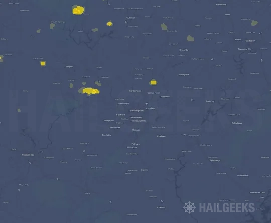


If none of these related Birmingham, AL hail maps look close enough to your property, check a free Hail Report by Address. It reviews hail history for a specific location — not just the broader Birmingham, AL region — so you can check whether hail activity may have reached your property.
Local Hail Review Options Near Birmingham, AL
Not sure whether the January 12, 2023 Birmingham, AL hail map matters for your property? Start with a free Hail Report by Address to see whether hail activity was mapped for that property. If the property signal looks meaningful, you can choose a local pro serving the Birmingham, AL region and ask about a Remote Hail Inspection before deciding whether an on-site roof or exterior review is worth scheduling.
Check a specific property to see whether hail activity from the January 12, 2023 Birmingham, AL event — or another recent hail event — may have been mapped at that address.
Find a roof or exterior pro serving the Birmingham, AL region who can help you understand what the property hail signal may mean.
A participating local pro reviews property-level hail history remotely — not just the January 12, 2023 event — to help decide whether an on-site inspection may be worth scheduling.
A free Hail Report by Address and a Remote Hail Inspection can help you look beyond the January 12, 2023 hail map visuals alone. They do not confirm property damage and do not replace an on-site inspection for a property in the Birmingham, AL region, but they can help you make a more informed next decision before anyone climbs on the roof.
Frequently Asked Questions
Common questions about the January 12, 2023 Birmingham, AL hail event.