
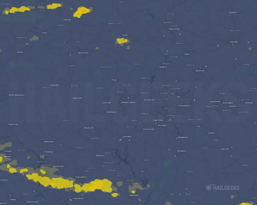
Hail Swath Map Preview
The Winston, NC hail swath map preview was last reviewed on August 28, 2026 and shows mapped hail estimates up to 1.00". There are 2 public hail reports, 76 public wind reports, and 2 nearby tornado reports listed for the August 7, 2023 event.
View the August 7, 2023 Winston, NC hail event on the free interactive hail map, then check a free Hail Report by ZIP to see a more local hail signal for your area.
Impact Area and Population for the Winston, NC Hail Map
The August 7, 2023 hail swath map for Winston, NC covers approximately 377 square miles and includes an estimated 113,866 people inside the mapped footprint. The largest mapped area is in the < 0.50" hail band, covering 220 square miles. The highest estimated population exposure is in the < 0.50" hail band with 65,192 people.
| Mapped Hail Band | Impact Area | Population |
|---|---|---|
| < 0.50" | 220 sq mi | 65,192 |
| 0.50-0.75" | 131 sq mi | 47,439 |
| 0.75-1.00" | 16 sq mi | 1,081 |
| 1.00-1.25" | 10 sq mi | 154 |
Get a free Hail Report by ZIP to see a more local hail signal and whether the August 7, 2023 Winston, NC hail event may have reached your area.
Housing Exposure Inside the Winston, NC Hail Swath Map
Inside the August 7, 2023 hail swath map area for Winston, NC, HailGeeks estimates 48,255 single-family homes, 3,357 townhomes, and 11,918 multifamily properties within the mapped storm footprint. Single-family-home exposure is highest in the < 0.50" hail band, with 27,786 single-family homes.
| Mapped Hail Band | Single-Family | Townhomes | Multifamily |
|---|---|---|---|
| < 0.50" | 27,786 | 1,732 | 7,924 |
| 0.50-0.75" | 19,642 | 1,622 | 3,987 |
| 0.75-1.00" | 695 | 3 | 7 |
| 1.00-1.25" | 132 | 0 | 0 |
Use this table to review housing exposure by hail band for the August 7, 2023 Winston, NC hail map. To check a specific property more closely, use a free Hail Report by Address.
Counties Inside the Winston, NC Hail Map
Hail from the August 7, 2023 storm was mapped across 12 counties in the Winston, NC region. Carroll County, VA had the strongest mapped signal, peaking at 1.00" with roughly 456 single-family homes inside the swath.
County pages group every mapped hail event in the area. For a closer look, drop to the city or ZIP level below, or run a free Hail Report by Address.
Cities Inside the Winston, NC Hail Map
Zooming in, the swath touched 11 cities near Winston, NC. Cornelius, NC had the strongest mapped signal at 0.50", with an estimated 5,942 single-family homes exposed.
City cards show where the August 7, 2023 Winston, NC hail activity was mapped, but your ZIP can show a closer local signal. Get a free Hail Report by ZIP, and if the signal looks meaningful, ask a local pro about a Remote Hail Inspection to see whether an on-site roof or exterior review may be worth scheduling.
ZIP Codes Inside the Winston, NC Hail Swath Map
At the ZIP level, the August 7, 2023 Winston, NC hail map spans 19 ZIP codes. ZIP 24325 shows the strongest local signal, with mapped hail estimates up to 1.00" and an estimated single-family-home exposure of 200.
Check your ZIP in seconds to see whether hail activity from the August 7, 2023 Winston, NC event was mapped near your area.
Public Hail, Wind, and Tornado Reports
Public storm report tables connected to the August 7, 2023 hail map for Winston, NC currently list 2 public hail reports, 76 public wind reports, and 2 tornado reports.
| Date & Time | Hail Size | City | State | Description |
|---|---|---|---|---|
August 7, 2023 2:23 PM CT |
1.25 in | 2 NE Dugspur | VA | Quarter to half-dollar sized hail was observed at the intersection of Highway 221 and Indian Valley Road. |
August 7, 2023 2:25 PM CT |
1.00 in | 1 N Willis | VA | No National Weather Service description provided. |
| Date & Time | Wind Speed | City | State | Description |
|---|---|---|---|---|
August 7, 2023 3:30 PM CT | 2 WNW Millersville | NC | Tree blocking roadway. | |
August 7, 2023 3:30 PM CT | 2 SSW Taylorsville | NC | Structural damage to Alexander County Fairgrounds. | |
August 7, 2023 3:30 PM CT | 2 WSW Taylorsville | NC | Tree blocking roadway. | |
August 7, 2023 3:30 PM CT | 3 W Millersville | NC | Tree blocking roadway. | |
August 7, 2023 3:30 PM CT | 2 NNW Millersville | NC | Power lines down on roadway. | |
August 7, 2023 3:30 PM CT | 2 W Millersville | NC | 8-inch diameter limbs sheared off trees. | |
August 7, 2023 3:30 PM CT | 1 E Bethlehem | NC | Tree down on roadway. | |
August 7, 2023 3:32 PM CT | 3 SSW Hiddenite | NC | Power lines and trees down. | |
August 7, 2023 3:35 PM CT | 1 WNW Stony Point | NC | Power lines and trees on roadway. | |
August 7, 2023 3:35 PM CT | 2 N Stony Point | NC | Powerlines down. | |
August 7, 2023 3:37 PM CT | 2 NNW Conover | NC | Social media picture of a large tree blown down along Herman Sipe Rd. | |
August 7, 2023 3:37 PM CT | 2 N Conover | NC | Trees down along County Home Rd. | |
August 7, 2023 3:37 PM CT | 2 W Newton | NC | Social media report of trees down on power lines along Flora Dr. | |
August 7, 2023 3:38 PM CT | 5 E Ararat | VA | Multiple trees were blown down in the community of Claudville by thunderstorm winds. | |
August 7, 2023 3:39 PM CT | 2 WSW Conover | NC | Social media report of trees down along Hwy 70 near the fairgrounds. | |
August 7, 2023 3:39 PM CT | Conover | NC | Social media picture of a greenhouse destroyed in Conover. | |
August 7, 2023 3:40 PM CT | Maiden | NC | Multiple social media reports of numerous trees and power lines down across Maiden. | |
August 7, 2023 3:40 PM CT | 2 SSW Taylorsville | NC | Significant roof damage to Lions Club building. | |
August 7, 2023 3:40 PM CT | 2 NW Stony Point | NC | Power lines down on roadway. | |
August 7, 2023 3:42 PM CT | 1 WSW Lincolnton | NC | Approx. 20-25 trees down across the county. About 2500 residents without power. | |
August 7, 2023 3:45 PM CT | 2 NW Claremont | NC | Social media report of multiple trees and power lines down in the Rock Barn area. | |
August 7, 2023 3:45 PM CT | 1 S Conover | NC | Numerous trees down in Conover. | |
August 7, 2023 3:45 PM CT | 1 N Claremont | NC | Social media picture of trees down on I-40 in Claremont. | |
August 7, 2023 3:46 PM CT | 3 E Newton | NC | Social media report of trees down on Bethany Rd and Claremont Rd. | |
August 7, 2023 3:48 PM CT | 3 NE Iron Station | NC | Trees down on roadway. | |
August 7, 2023 3:48 PM CT | 5 NE Boger City | NC | Trees down on roadway. | |
August 7, 2023 3:48 PM CT | 5 NNE Lowesville | NC | Social media photo of tree on roadway. | |
August 7, 2023 3:48 PM CT | 3 S Catawba | NC | Social media picture of trees down along Millstone Dr. | |
August 7, 2023 3:48 PM CT | 3 SW Catawba | NC | Auto body shop severely damaged on Balls Creek Rd near Hwy 10. Trees down around Murrays Mill. | |
August 7, 2023 3:54 PM CT | 3 S Stuart | VA | Multiple trees were blown down across the southern end of the community of Stuart by thunderstorm winds. | |
August 7, 2023 4:00 PM CT | 4 NE Terrell | NC | Report of a roof blown off house on Fern Haven Ln... and Fern Hill Rd. blocked due to trees down. | |
August 7, 2023 4:02 PM CT | 3 WSW Critz | VA | Tops of trees blown off and 1 tree uprooted. | |
August 7, 2023 4:05 PM CT | Ranlo | NC | Power lines down in Ranlo. Time estimated from radar. | |
August 7, 2023 4:06 PM CT | 1 NE Mooresville | NC | Social media video of numerous trees down blocking McNeely street... some on adjacent homes. | |
August 7, 2023 4:12 PM CT | 1 WNW Penns Store | VA | Thunderstorm winds blew a tree down along Route 58... approximately four miles west of Spencer. Report in Twitter. | |
August 7, 2023 4:12 PM CT | 2 N Huntersville | NC | Trees down on roadway. | |
August 7, 2023 4:15 PM CT | 4 NNW Enochville | NC | Report of a roof blown off a house on Cooriher Grange Rd. Also lots of trees down along Hwy 152 between Unity Church Rd and Millbridge Rd. Time estimated from radar. | |
August 7, 2023 4:16 PM CT | 1 SE Penns Store | VA | Multiple trees were blown down along Penn Store Road by thunderstorm winds. | |
August 7, 2023 4:17 PM CT | 1 WNW Horse Pasture | VA | A large tree was blown down across a power line along Marigold Road by thunderstorm winds. Power is out in the local area. | |
August 7, 2023 4:18 PM CT | Landis | NC | Multiple large trees down in Landis. Time estimated from radar. | |
August 7, 2023 4:18 PM CT | 3 NNW Concord | NC | Tree through roof on home. | |
August 7, 2023 4:19 PM CT | 1 SSW Spencer | VA | A tree was blown down onto a home along Old Well Road by thunderstorm winds... trapping a resident inside the home. | |
August 7, 2023 4:19 PM CT | 4 NNW Paw Creek | NC | Power lines down on Hart Road. | |
August 7, 2023 4:20 PM CT | Horse Pasture | VA | A large tree was blown down by thunderstorm winds near the intersection of Highway 58 and Soapstone Road. | |
August 7, 2023 4:20 PM CT | 3 ENE Mooresville | NC | Trees on home... residents trapped. | |
August 7, 2023 4:20 PM CT | 1 N Mooresville | NC | Trees down on home... residents trapped. | |
August 7, 2023 4:20 PM CT | 2 W Mooresville | NC | Trees down on home. | |
August 7, 2023 4:22 PM CT | 3 SSE Croft | NC | Tree fell on house on Pensfold Dr. | |
August 7, 2023 4:22 PM CT | Mocksville | NC | Report of numerous trees down across Davie County. Time estimated from radar. | |
August 7, 2023 4:22 PM CT | 4 SW Enochville | NC | Social media picture of trees down in northwest Cabarrus County. | |
August 7, 2023 4:27 PM CT | 1 ENE Concord | NC | Report of multiple trees down in Concord. Time estimated from radar. | |
August 7, 2023 4:30 PM CT | 4 N China Grove | NC | NCDOT reports trees down near the intersection of Cooper Rd and Miller Rd. | |
August 7, 2023 4:30 PM CT | 1 E Salisbury | NC | Several social media pictures of trees and power lines down in the Salisbury area. | |
August 7, 2023 4:30 PM CT | 5 WSW Salisbury | NC | NCDOT reports trees down in Twin Chapel. | |
August 7, 2023 4:30 PM CT | 3 ENE Croft | NC | Emergency Manager reports tree down on powerline. | |
August 7, 2023 4:30 PM CT | Harrisburg | NC | Multiple trees down in Harrisburg. | |
August 7, 2023 4:35 PM CT | 1 NNE Granite Quarry | NC | NCDOT reports trees down on Old Stone House Rd. | |
August 7, 2023 4:35 PM CT | 2 WSW Craven | NC | NCDOT reports trees down on Providence Church Rd. | |
August 7, 2023 4:35 PM CT | 3 WSW Faith | NC | NCDOT reports trees down on Correll Farm Rd. | |
August 7, 2023 4:35 PM CT | 3 SSW Faith | NC | NCDOT reports trees down on NC 152 HWY. | |
August 7, 2023 4:35 PM CT | 1 NNW Unc Charlotte | NC | Emergency Management reports several locations with trees down on UNC Charlotte campus. | |
August 7, 2023 4:40 PM CT | 3 SSE Winston-Salem | NC | Tree on house. no injuries reported. | |
August 7, 2023 4:40 PM CT | 5 NNW High Rock | NC | Trees down across the county especially near high rock lake. | |
August 7, 2023 4:40 PM CT | 2 NE Lexington | NC | multiple trees down across the county. Including areas of Lexington and Southmont. | |
August 7, 2023 4:40 PM CT | 3 SSW Rockwell | NC | NCDOT reports trees down on Sand Rd. | |
August 7, 2023 4:45 PM CT | 1 S Albemarle | NC | trees down all over the county including a tree down on an apartment building in Albermarle. | |
August 7, 2023 4:50 PM CT | 3 ENE Croft | NC | Emergency Manager reports trees down on roadway. | |
August 7, 2023 4:50 PM CT | 4 SSE Croft | NC | Emergency Manager reports trees down on roadway. | |
August 7, 2023 5:00 PM CT | Eldorado | NC | Many trees reported down across Montgomery county. | |
August 7, 2023 5:10 PM CT | 3 WNW Asheboro | NC | trees down on Old Lexington Rd. | |
August 7, 2023 5:14 PM CT | 1 NE Randleman | NC | Trees down on Fox St. | |
August 7, 2023 5:25 PM CT | Mcleansville | NC | Trees/power lines down countywide. | |
August 7, 2023 5:40 PM CT | 6 NE Siler City | NC | Trees/power lines down at Silk Hope Rd & George Hudson Rd. | |
August 7, 2023 5:45 PM CT | 4 SW Robbins | NC | A few hundred power outages due to trees down on equipment. | |
August 7, 2023 6:00 PM CT | 1 NNW Sanford | NC | Multiple trees reported down near US-1 and Sanford. | |
August 7, 2023 4:00 PM CT | 65 mph | 4 ESE Terrell | NC | Social media report of severe gust. |
| Date & Time | Rating | City | State | Description |
|---|---|---|---|---|
August 7, 2023 3:40 PM CT | UNK | 1 SW Claremont | NC | An EF-1 tornado with peak winds of 110mph tracked across portions of Catawba... Iredell and Rowan Counties on the afternoon of August 7th. The tornado touched down between Conover and Claremont on Kelly Blvd where large tree branches were snapped. The tornado moved southeast and continued to snap large tree limbs as it neared the Murrays Hill community. The tornado began to strengthen and reached EF-1 intensity as it crossed NC Highway 10 where trees were uprooted with additional trees snapped/uprooted along Murrays Mill Rd and Sherrills Ford Rd with winds reaching 100-110mph. The tornado maintained EF-1 intensity as it passed just north of Sherrills Ford downing trees along Long Island Rd... Hopewell Church Rd and Mollys Backbone Rd. The tornado crossed Lake Norman and moved into Iredell County downing many trees along Northview Harbor Dr... Penicillin Pt and Fern Hill Rd. As the tornado neared Mooresville it began to lose intensity and weakened to an EF-0 with 70-85mph winds snapping nu |
August 7, 2023 4:06 PM CT | UNK | 4 ESE Lowesville | NC | The NWS office in Greenville-Spartanburg has confirmed and EF0 tornado touched down just south of Lake Norman in Mecklenburg County... NC Monday evening. The tornado was rated EF0 with peak winds of 85mph. Damage consisted of numerous tree branches torn off... some trees uprooted... and some minor damage to building exteriors. |
This table includes only public storm reports connected to the August 7, 2023 Winston, NC storm event. When available, each report may include the time, size or magnitude, city, state, and a short description.
Related Hail Maps in the Winston, NC Region
We found 6 more hail maps with reports from the same Winston, NC region as the August 7, 2023 event. These related maps cover storm dates from Jul 14, 2023 through Jul 31, 2023, with mapped hail estimates ranging from 0.75" to 1.75". In this set, the strongest related map reached 1.75", and the most recent map shown is from Jul 31, 2023.


If none of these related Winston, NC hail maps look close enough to your property, check a free Hail Report by Address. It reviews hail history for a specific location — not just the broader Winston, NC region — so you can check whether hail activity may have reached your property.
Local Hail Review Options Near Winston, NC
Not sure whether the August 7, 2023 Winston, NC hail map matters for your property? Start with a free Hail Report by Address to see whether hail activity was mapped for that property. If the property signal looks meaningful, you can choose a local pro serving the Winston, NC region and ask about a Remote Hail Inspection before deciding whether an on-site roof or exterior review is worth scheduling.
Check a specific property to see whether hail activity from the August 7, 2023 Winston, NC event — or another recent hail event — may have been mapped at that address.
Find a roof or exterior pro serving the Winston, NC region who can help you understand what the property hail signal may mean.
A participating local pro reviews property-level hail history remotely — not just the August 7, 2023 event — to help decide whether an on-site inspection may be worth scheduling.
A free Hail Report by Address and a Remote Hail Inspection can help you look beyond the August 7, 2023 hail map visuals alone. They do not confirm property damage and do not replace an on-site inspection for a property in the Winston, NC region, but they can help you make a more informed next decision before anyone climbs on the roof.
Frequently Asked Questions
Common questions about the August 7, 2023 Winston, NC hail event.