
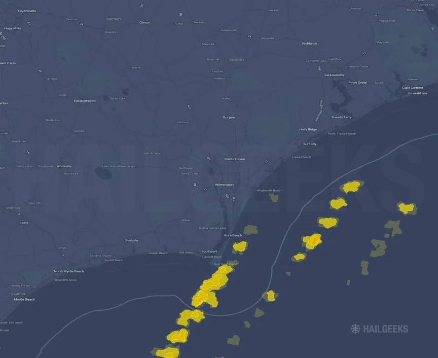
Hail Swath Map Preview
The Wilmington, NC hail swath map preview was last reviewed on August 28, 2026 and shows mapped hail estimates up to 1.00". There are 1 public hail reports, 41 public wind reports, and 0 nearby tornado reports listed for the January 9, 2024 event.
View the January 9, 2024 Wilmington, NC hail event on the free interactive hail map, then check a free Hail Report by ZIP to see a more local hail signal for your area.
Impact Area and Population for the Wilmington, NC Hail Map
The January 9, 2024 hail swath map for Wilmington, NC covers approximately 266 square miles and includes an estimated 2 people inside the mapped footprint. The largest mapped area is in the < 0.50" hail band, covering 128 square miles. The highest estimated population exposure is in the 0.50-0.75" hail band with 2 people.
| Mapped Hail Band | Impact Area | Population |
|---|---|---|
| < 0.50" | 128 sq mi | 0 |
| 0.50-0.75" | 105 sq mi | 2 |
| 0.75-1.00" | 26 sq mi | 0 |
| 1.00-1.25" | 6 sq mi | 0 |
Get a free Hail Report by ZIP to see a more local hail signal and whether the January 9, 2024 Wilmington, NC hail event may have reached your area.
Housing Exposure Inside the Wilmington, NC Hail Swath Map
Inside the January 9, 2024 hail swath map area for Wilmington, NC, HailGeeks estimates 21 single-family homes, 0 townhomes, and 1 multifamily properties within the mapped storm footprint. Single-family-home exposure is highest in the 0.50-0.75" hail band, with 21 single-family homes.
| Mapped Hail Band | Single-Family | Townhomes | Multifamily |
|---|---|---|---|
| 0.50-0.75" | 21 | 0 | 1 |
Use this table to review housing exposure by hail band for the January 9, 2024 Wilmington, NC hail map. To check a specific property more closely, use a free Hail Report by Address.
Counties Inside the Wilmington, NC Hail Map
Hail from the January 9, 2024 storm was mapped across 1 counties in the Wilmington, NC region. Brunswick County, NC had the strongest mapped signal, peaking at 0.50" with roughly 14 single-family homes inside the swath.
County pages group every mapped hail event in the area. For a closer look, drop to the city or ZIP level below, or run a free Hail Report by Address.
Cities Inside the Wilmington, NC Hail Map
Zooming in, the swath touched 1 cities near Wilmington, NC. Bald Head Island, NC had the strongest mapped signal at 0.50", with an estimated 14 single-family homes exposed.
City cards show where the January 9, 2024 Wilmington, NC hail activity was mapped, but your ZIP can show a closer local signal. Get a free Hail Report by ZIP, and if the signal looks meaningful, ask a local pro about a Remote Hail Inspection to see whether an on-site roof or exterior review may be worth scheduling.
ZIP Codes Inside the Wilmington, NC Hail Swath Map
At the ZIP level, the January 9, 2024 Wilmington, NC hail map spans 1 ZIP codes. ZIP 28461 shows the strongest local signal, with mapped hail estimates up to 0.50" and an estimated single-family-home exposure of 14.
Check your ZIP in seconds to see whether hail activity from the January 9, 2024 Wilmington, NC event was mapped near your area.
Public Hail, Wind, and Tornado Reports
Public storm report tables connected to the January 9, 2024 hail map for Wilmington, NC currently list 1 public hail reports, 41 public wind reports, and 0 tornado reports.
| Date & Time | Hail Size | City | State | Description |
|---|---|---|---|---|
January 9, 2024 3:39 PM CT |
1.00 in | 2 SSW Carolina Beach | NC | Quarter-sized hail reported near Spot Lane in Carolina Beach. Time estimated via radar. |
| Date & Time | Wind Speed | City | State | Description |
|---|---|---|---|---|
January 9, 2024 2:08 PM CT | 5 SSW Elizabethtown | NC | Tree down along Mercer Mill Brown Marsh Rd. | |
January 9, 2024 2:18 PM CT | 7 ENE Elizabethtown | NC | Power line down along Hope Drive near intersection with White Lake Drive. | |
January 9, 2024 3:50 PM CT | 9 NE Elizabethtown | NC | Tree down along Johnsontown Rd. near the intersection with US-701. | |
January 9, 2024 4:25 PM CT | 2 NE Sea View Pier | NC | Jones Onslow Electric Cooperative reported trees on powerlines. Time based on radar. | |
January 9, 2024 4:30 PM CT | 5 ENE Tar Heel | NC | Tree down at Burney Rd and Jessie Dr... and tree down near the White Oak Fire Department on Hwy 53. | |
January 9, 2024 4:33 PM CT | New River Station | NC | MCAS New River Air Station Emergency Manager reported a tree downed powerlines along Flounder Rd. Time based on radar. | |
January 9, 2024 4:35 PM CT | Verona | NC | Jones Onslow Electric Cooperative reported trees on powerlines in Verona. Time based on radar. | |
January 9, 2024 4:38 PM CT | 7 SSW Loris | SC | Tree down in roadway on Adrian Highway (Hwy 139) near New Home Circle | |
January 9, 2024 4:50 PM CT | 4 W Nakina | NC | Tree down along Furnie Hammond Rd. | |
January 9, 2024 5:05 PM CT | 3 WSW Swansboro | NC | Tree down. | |
January 9, 2024 5:11 PM CT | 10 NNE Fair Bluff | NC | A cedar tree fell on a house along Old Boardman Road in Evergreen. Damage is consistent with straight line winds at about 75 mph. Time estimated by radar. | |
January 9, 2024 5:13 PM CT | 9 NW Chadbourn | NC | Tree down along Old US Hwy 74 near intersection with Mangum Rd. | |
January 9, 2024 5:13 PM CT | 6 NNW Chadbourn | NC | Tree down at MM230 along US-74. | |
January 9, 2024 5:15 PM CT | 6 WNW Chadbourn | NC | Tree blocking Princess Ann Rd. Time estimated based on radar. | |
January 9, 2024 5:25 PM CT | 3 WNW Chadbourn | NC | Tree down at Princess Ann Rd. and Alfred Hayes Dr. | |
January 9, 2024 5:25 PM CT | Chadbourn | NC | Tree down on Main Street in Chadbourn. | |
January 9, 2024 5:45 PM CT | Elizabethtown | NC | Several trees and some power lines down in the Elizabethtown area. | |
January 9, 2024 5:45 PM CT | Whiteville | NC | Structural damage at a building on Lee Avenue in Whiteville. Winds ripped the roof off the building at this location. | |
January 9, 2024 5:45 PM CT | 9 ESE Bladenboro | NC | Trees down on Brown Marsh Rd... Red Hill Rd... and W S Railroad St. in the Clarkton area. | |
January 9, 2024 6:15 PM CT | 1 SOUTH Beulaville | NC | Duplin County Emergency Management reported roof partially blown off... no injuries. Time based on radar. | |
January 9, 2024 6:21 PM CT | 2 NNW Silver Lake | NC | Tree down blocking roadway in the 300 block of Raleigh St. Time estimated based on radar. | |
January 9, 2024 6:22 PM CT | 2 NNW Wilmington | NC | Large tree down partially blocking Market St. between 17th St. and 18th St. Time estimated based on radar and ASOS observations. | |
January 9, 2024 6:24 PM CT | 2 NE Wilmington | NC | Tree down blocking roadway in 4100 block of Emerson St... near intersection with Marlboro St. Time estimated based on radar. | |
January 9, 2024 6:25 PM CT | 1 SSE Windemere | NC | Tree down blocking Rogersville Rd. near intersection with Telephone Rd. Time estimated based on radar. | |
January 9, 2024 6:28 PM CT | 2 SW Wilmington | NC | A wooden facade along a staircase in an apartment building was pushed out onto the sidewalk by about 8-10 inches. This splinted the wooden facade and broke the plastic siding. Time estimated by radar. | |
January 9, 2024 6:30 PM CT | Pollocksville | NC | Jones County Emergency Management reported trees down in Pollocksville. Time based on radar. | |
January 9, 2024 6:30 PM CT | Maysville | NC | Jones County Emergency Management reported trees down in Maysville. Time based on radar. | |
January 9, 2024 6:30 PM CT | 4 W Teachey | NC | Duplin County Emergency Management reported a trampoline blown into powerlines. Time based on radar. | |
January 9, 2024 6:35 PM CT | 1 W Wallace | NC | Duplin County Emergency Management reported trees down on an apartment... partial roof collapse. No injuries. Time based on radar. | |
January 9, 2024 3:22 PM CT | 65 mph | 1 SE Bald Head Island | NC | Residential weather station recorded a 65 mph wind gust in Bald Head Island. Time estimated by radar. |
January 9, 2024 4:54 PM CT | 62 mph | 4 ENE Hope Mills | NC | KFAY ASOS. |
January 9, 2024 5:11 PM CT | 60 mph | 2 N Hampstead | NC | Wind gust to 60mph estimated in the Castle Bay Golf Course community. |
January 9, 2024 5:12 PM CT | 62 mph | 1 S Bogue | NC | Marine Corp Air Station Bogue Field (NJM) observed a 54 knot (62 mph) thunderstorm wind gust. |
January 9, 2024 5:12 PM CT | 62 mph | 2 SSE Bogue | NC | Marine Corp Air Station Bogue Field (NJM) observed a 54 knot (62 mph) thunderstorm wind gust. |
January 9, 2024 5:49 PM CT | 62 mph | North Myrtle Beach | SC | The ASOS station at KCRE recorded a wind gust of 54 knots (62 mph). |
January 9, 2024 6:23 PM CT | 73 mph | Wilmington Intl Arpt | NC | The ASOS station at KILM recorded a wind gust of 73 mph. |
January 9, 2024 6:37 PM CT | 78 mph | New River Station | NC | KNCA. |
January 9, 2024 6:57 PM CT | 80 mph | 1 E Surf City | NC | Davis weather station at the Surf City Ocean Pier recorded a wind gust of 80 mph. Time estimated by radar. |
January 9, 2024 7:05 PM CT | 72 mph | 1 ENE Surf City | NC | Peak gust measured on Surf City Bridge. Sensor located near Topsail Island side... well below peak bridge elevation. |
January 9, 2024 7:05 PM CT | 59 mph | 1 NE Sea View Pier | NC | Public weather station reported a 51 kt wind gust. |
January 9, 2024 7:16 PM CT | 77 mph | Coastal Carolina Region | NC | KEWN. |
| Date & Time | Rating | City | State | Description |
|---|---|---|---|---|
| No public tornado reports are available for this event. | ||||
This table includes only public storm reports connected to the January 9, 2024 Wilmington, NC storm event. When available, each report may include the time, size or magnitude, city, state, and a short description.
Related Hail Maps in the Wilmington, NC Region
We found 6 more hail maps with reports from the same Wilmington, NC region as the January 9, 2024 event. These related maps cover storm dates from Jul 20, 2023 through Sep 8, 2023, with mapped hail estimates ranging from 0.75" to 1.00". In this set, the strongest related map reached 1.00", and the most recent map shown is from Sep 8, 2023.


If none of these related Wilmington, NC hail maps look close enough to your property, check a free Hail Report by Address. It reviews hail history for a specific location — not just the broader Wilmington, NC region — so you can check whether hail activity may have reached your property.
Local Hail Review Options Near Wilmington, NC
Not sure whether the January 9, 2024 Wilmington, NC hail map matters for your property? Start with a free Hail Report by Address to see whether hail activity was mapped for that property. If the property signal looks meaningful, you can choose a local pro serving the Wilmington, NC region and ask about a Remote Hail Inspection before deciding whether an on-site roof or exterior review is worth scheduling.
Check a specific property to see whether hail activity from the January 9, 2024 Wilmington, NC event — or another recent hail event — may have been mapped at that address.
Find a roof or exterior pro serving the Wilmington, NC region who can help you understand what the property hail signal may mean.
A participating local pro reviews property-level hail history remotely — not just the January 9, 2024 event — to help decide whether an on-site inspection may be worth scheduling.
A free Hail Report by Address and a Remote Hail Inspection can help you look beyond the January 9, 2024 hail map visuals alone. They do not confirm property damage and do not replace an on-site inspection for a property in the Wilmington, NC region, but they can help you make a more informed next decision before anyone climbs on the roof.
Frequently Asked Questions
Common questions about the January 9, 2024 Wilmington, NC hail event.