
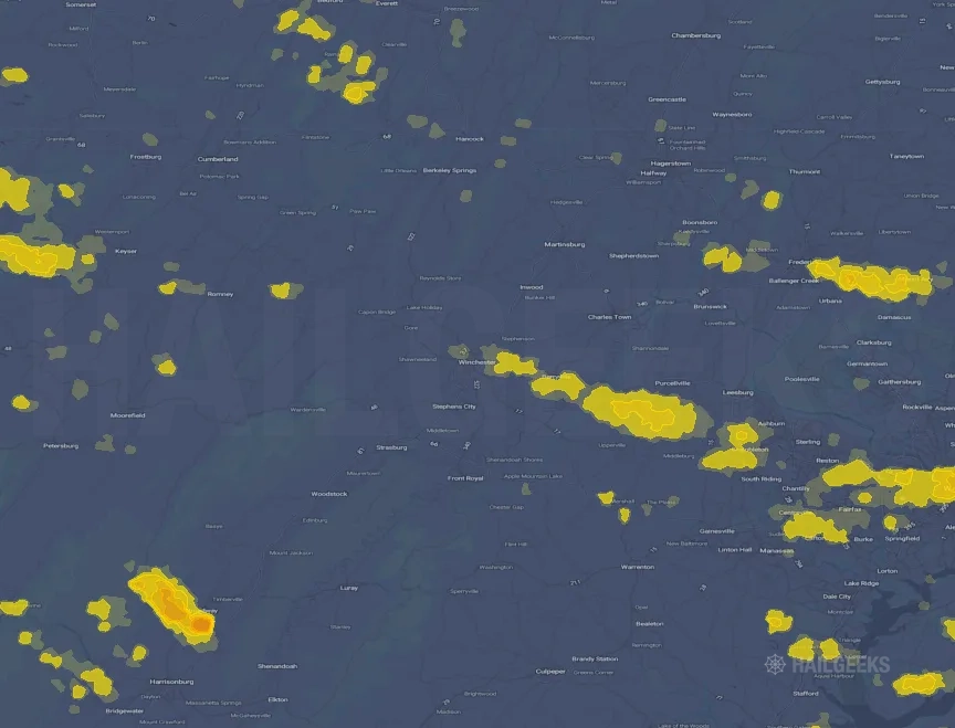
Hail Swath Map Preview
The Winchester, VA hail swath map preview was last reviewed on September 6, 2026 and shows mapped hail estimates up to 1.50". There are 2 public hail reports, 52 public wind reports, and 0 nearby tornado reports listed for the September 3, 2026 event.
View the September 3, 2026 Winchester, VA hail event on the free interactive hail map, then check a free Hail Report by ZIP to see a more local hail signal for your area.
Impact Area and Population for the Winchester, VA Hail Map
The September 3, 2026 hail swath map for Winchester, VA covers approximately 656 square miles and includes an estimated 301,108 people inside the mapped footprint. The largest mapped area is in the < 0.50" hail band, covering 334 square miles. The highest estimated population exposure is in the < 0.50" hail band with 192,973 people.
| Mapped Hail Band | Impact Area | Population |
|---|---|---|
| < 0.50" | 334 sq mi | 192,973 |
| 0.50-0.75" | 233 sq mi | 89,908 |
| 0.75-1.00" | 61 sq mi | 14,682 |
| 1.00-1.25" | 13 sq mi | 1,188 |
| 1.25-1.50" | 11 sq mi | 1,051 |
| 1.50-1.75" | 5 sq mi | 1,306 |
Get a free Hail Report by ZIP to see a more local hail signal and whether the September 3, 2026 Winchester, VA hail event may have reached your area.
Housing Exposure Inside the Winchester, VA Hail Swath Map
Inside the September 3, 2026 hail swath map area for Winchester, VA, HailGeeks estimates 79,205 single-family homes, 34,344 townhomes, and 23,463 multifamily properties within the mapped storm footprint. Single-family-home exposure is highest in the < 0.50" hail band, with 44,785 single-family homes.
| Mapped Hail Band | Single-Family | Townhomes | Multifamily |
|---|---|---|---|
| < 0.50" | 44,785 | 24,538 | 19,802 |
| 0.50-0.75" | 27,544 | 8,730 | 2,990 |
| 0.75-1.00" | 5,543 | 859 | 423 |
| 1.00-1.25" | 530 | 38 | 58 |
| 1.25-1.50" | 410 | 59 | 41 |
| 1.50-1.75" | 393 | 120 | 149 |
Use this table to review housing exposure by hail band for the September 3, 2026 Winchester, VA hail map. To check a specific property more closely, use a free Hail Report by Address.
Counties Inside the Winchester, VA Hail Map
Hail from the September 3, 2026 storm was mapped across 24 counties in the Winchester, VA region. Rockingham County, VA had the strongest mapped signal, peaking at 1.50" with roughly 2,318 single-family homes inside the swath.
County pages group every mapped hail event in the area. For a closer look, drop to the city or ZIP level below, or run a free Hail Report by Address.
Cities Inside the Winchester, VA Hail Map
Zooming in, the swath touched 34 cities near Winchester, VA. Broadway, VA had the strongest mapped signal at 1.50", with an estimated 315 single-family homes exposed.
City cards show where the September 3, 2026 Winchester, VA hail activity was mapped, but your ZIP can show a closer local signal. Get a free Hail Report by ZIP, and if the signal looks meaningful, ask a local pro about a Remote Hail Inspection to see whether an on-site roof or exterior review may be worth scheduling.
ZIP Codes Inside the Winchester, VA Hail Swath Map
At the ZIP level, the September 3, 2026 Winchester, VA hail map spans 54 ZIP codes. ZIP 22815 shows the strongest local signal, with mapped hail estimates up to 1.50" and an estimated single-family-home exposure of 1,520.
Check your ZIP in seconds to see whether hail activity from the September 3, 2026 Winchester, VA event was mapped near your area.
Public Hail, Wind, and Tornado Reports
Public storm report tables connected to the September 3, 2026 hail map for Winchester, VA currently list 2 public hail reports, 52 public wind reports, and 0 tornado reports.
| Date & Time | Hail Size | City | State | Description |
|---|---|---|---|---|
September 3, 2026 1:00 PM CT |
1.00 in | 1 S Broadway | VA | Quarter size hail reported from trained spotter. |
September 3, 2026 1:04 PM CT |
1.75 in | 2 S Broadway | VA | Video footage showing golf ball size hail reported near Broadway. |
| Date & Time | Wind Speed | City | State | Description |
|---|---|---|---|---|
September 3, 2026 9:15 PM CT | Frederick | MD | Tree & wires down along Magnolia and Evergreen Ave. Time estimated via radar. | |
September 3, 2026 10:23 PM CT | Sterling Park | VA | Tree & wires down along W Maple Avenue. Time estimated via radar. | |
September 3, 2026 10:50 PM CT | Gaithersburg | MD | Tree down along 9300 block of Mercy Hollow Lane. | |
September 3, 2026 8:49 PM CT | Points | WV | Tree down on CR-3 Slanesville Pk at CR-5 Springfield Pk/Jersey Mountain Rd | |
September 3, 2026 10:43 PM CT | Alexandria | VA | Tree down on VA-420 Seminary Rd at Fort Williams Pkwy | |
September 3, 2026 8:42 PM CT | Flintstone | MD | Trees down on Flintstone Creek Rd | |
September 3, 2026 10:39 PM CT | Lake Barcroft | VA | Downed trees on Waterway Dr and Waterway Pl | |
September 3, 2026 7:27 PM CT | Flintstone | MD | Trees down on Flintstone Creek Rd | |
September 3, 2026 10:44 PM CT | 71 mph | Ballston | VA | Sustained wind of 50 knots (58 MPH) with peak gust of 62 knots (71 MPH) at a personal weather station in Ballston (KVAARLIN3) |
September 3, 2026 10:45 AM CT | 2 Ene Ravensworth | VA | Multiple trees & wires reported down across Fairfax county due to thunderstorm winds. | |
September 3, 2026 1:06 PM CT | 3 Sse Broadway | VA | A tree was down along Phillips Store Road. | |
September 3, 2026 7:28 PM CT | 1 Nnw Flintstone | MD | Tree down near Flintstone Creek Road and Laurel Branch Trail. Time estimated via radar. | |
September 3, 2026 7:30 PM CT | 4 Ese Flintstone | MD | Trees down in the 25000 block of Koontz Rd | |
September 3, 2026 7:38 PM CT | 5 Nw Little Orleans | MD | Trees down in the 11400 block of 15 Mile Creek Rd | |
September 3, 2026 8:13 PM CT | 6 Ne Deer Park | MD | Tree down near Bittinger Road. Time estimated via radar. | |
September 3, 2026 8:35 PM CT | 1 E Cumberland | MD | Trees down on Pine Ave | |
September 3, 2026 8:35 PM CT | 1 Ene La Vale | MD | Trees down in the unit block of National Hwy SW | |
September 3, 2026 8:35 PM CT | 1 S La Vale | MD | Trees down in the 29400 block of US-40 ALT National Hwy | |
September 3, 2026 8:42 PM CT | 4 Ese Flintstone | MD | Trees down in the 25000 block of Koontz Rd | |
September 3, 2026 8:49 PM CT | 1 Nnw Lonaconing | MD | Trees down on Douglas Ave | |
September 3, 2026 8:49 PM CT | 2 Nw Lonaconing | MD | Trees down on Red Bird Ln | |
September 3, 2026 8:56 PM CT | 2 N Warnocks | MD | Tree down along Bloomington Hill Road. Time estimated via radar. | |
September 3, 2026 9:25 PM CT | 3 E Buckeystown | MD | Tree down along Park Mills Road. Time estimated via radar. | |
September 3, 2026 9:27 PM CT | 4 Nne Russelldale | WV | Tree down in the 9500 block of CR-11 Upper Patterson Creek Rd | |
September 3, 2026 9:35 PM CT | 1 Ene Watersville | MD | Large tree limbs snapped along Flag Marsh Rd | |
September 3, 2026 9:57 PM CT | 2 Wnw Philomont | VA | Trees down on VA-700 Woodtrail Rd near Deer Pond Ln | |
September 3, 2026 10:03 PM CT | 3 Se Round Hill | VA | Trees & wires down along Silcott Springs Road and Purcellville. | |
September 3, 2026 10:14 PM CT | 3 Ne Gainesville | VA | Tree down near Pageland Lane and Artemus Road. Time estimated via radar. | |
September 3, 2026 10:23 PM CT | 1 Ese Woolsey | VA | Tree down at Lawnvale Drive and Sudley Road. | |
September 3, 2026 10:29 PM CT | 1 Nnw Wolf Trap | VA | Downed trees at the intersection of Westford Dr and Blandfield Ct | |
September 3, 2026 10:30 PM CT | 62 mph | 1 Sse Arcola | VA | Elaine E. Thompson Elementary School (NGA65) gusted to 62 mph at 11:30 pm. |
September 3, 2026 10:31 PM CT | Vienna | VA | Several large trees down on wires_ including on Hilcrest Dr SW | |
September 3, 2026 10:34 PM CT | 69 mph | 1 Nnw Tysons Corner | VA | Wind gust of 69 mph measured on Tyco Rd in Tysons (KVAVIENN164 PWS) |
September 3, 2026 10:35 PM CT | 1 Nnw Ravensworth | VA | Downed trees near the intersection of Private Ln and Autumn Lake Wy | |
September 3, 2026 10:35 PM CT | 1 S The I66 And I495 | VA | Tree down on I-495 Capital Beltway at US-50 | |
September 3, 2026 10:36 PM CT | 1 Nnw Falls Church | VA | Several trees and large branches down along I-66 near VA-267 Dulles Toll Rd | |
September 3, 2026 10:36 PM CT | 1 Sw Falls Church | VA | Tree down near Woodlawn Avenue. Time estimated via radar. | |
September 3, 2026 10:38 PM CT | 2 Ene Congressional Man | MD | Trees down on MD-191 Bradley Blvd at Oak Forest Ln | |
September 3, 2026 10:39 PM CT | 1 N Congressional Manor | MD | Tree down on house in the 9300 block of Mercy Hollow Lane. | |
September 3, 2026 10:41 PM CT | 1 Sw Barcroft | VA | Downed trees and wires at the intersection of Washington Ct and Forest Dr | |
September 3, 2026 10:41 PM CT | 1 Wnw Rosslyn | VA | Numerous large trees down along GW Pkwy near Spout Run Pkwy closing the road for several hours | |
September 3, 2026 10:42 PM CT | 1 E Lincolnia | VA | Tree and wires down at the intersection of N Morgan St and N Beauregard St | |
September 3, 2026 10:42 PM CT | 1 Sw Barcroft | VA | Tree and power lines down near the intersection of Seminary Rd and Fillmore Ave | |
September 3, 2026 10:42 PM CT | 1 W Franconia | VA | Gazebo blew onto Metro tracks at Franconia-Sprinfield | |
September 3, 2026 10:42 PM CT | 2 Ese Lincolnia | VA | Tree down at the intersection of VA-236 Duke St and N Ripley St | |
September 3, 2026 10:42 PM CT | 2 Se Lincolnia | VA | Tree down at the intersection of Edsall Rd and S Van Dorn St | |
September 3, 2026 10:42 PM CT | 2 Sw Barcroft | VA | Downed trees on Colfax Ave and Bradley Blvd | |
September 3, 2026 10:44 PM CT | 1 Ene Alexandria | VA | Tree down on W Braddock Rd at W Windsor Ave | |
September 3, 2026 10:44 PM CT | 1 Nne Rose Hill | VA | Downed trees at the intersection of Elmwood Dr and Edgemont Dr | |
September 3, 2026 10:45 PM CT | 2 Ene Ravensworth | VA | Multiple trees & wires reported down across Fairfax county due to thunderstorm winds. | |
September 3, 2026 10:47 PM CT | 1 Se The I66 And I495 | VA | Tree on a house in 3000 Block of Woodlawn Avenue. | |
September 3, 2026 10:49 PM CT | 1 Ene Hybla Valley | VA | Downed trees on VA-629 Fort Hunt Rd and Mason Hill Dr |
| Date & Time | Rating | City | State | Description |
|---|---|---|---|---|
| No public tornado reports are available for this event. | ||||
This table includes only public storm reports connected to the September 3, 2026 Winchester, VA storm event. When available, each report may include the time, size or magnitude, city, state, and a short description.
Related Hail Maps in the Winchester, VA Region
We found 6 more hail maps with reports from the same Winchester, VA region as the September 3, 2026 event. These related maps cover storm dates from Aug 8, 2026 through Sep 4, 2026, with mapped hail estimates ranging from 1.00" to 2.25". In this set, the strongest related map reached 2.25", and the most recent map shown is from Sep 4, 2026.


If none of these related Winchester, VA hail maps look close enough to your property, check a free Hail Report by Address. It reviews hail history for a specific location — not just the broader Winchester, VA region — so you can check whether hail activity may have reached your property.
Local Hail Review Options Near Winchester, VA
Not sure whether the September 3, 2026 Winchester, VA hail map matters for your property? Start with a free Hail Report by Address to see whether hail activity was mapped for that property. If the property signal looks meaningful, you can choose a local pro serving the Winchester, VA region and ask about a Remote Hail Inspection before deciding whether an on-site roof or exterior review is worth scheduling.
Check a specific property to see whether hail activity from the September 3, 2026 Winchester, VA event — or another recent hail event — may have been mapped at that address.
Find a roof or exterior pro serving the Winchester, VA region who can help you understand what the property hail signal may mean.
A participating local pro reviews property-level hail history remotely — not just the September 3, 2026 event — to help decide whether an on-site inspection may be worth scheduling.
A free Hail Report by Address and a Remote Hail Inspection can help you look beyond the September 3, 2026 hail map visuals alone. They do not confirm property damage and do not replace an on-site inspection for a property in the Winchester, VA region, but they can help you make a more informed next decision before anyone climbs on the roof.
Frequently Asked Questions
Common questions about the September 3, 2026 Winchester, VA hail event.